- County Longford
-
County Longford
Contae an LongfoirtKarte 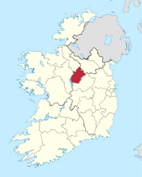
Basisdaten Staat: Irland Verwaltungssitz: Longford Provinz: Leinster irischer Name: An Longfort Fläche: 1.091 km² Einwohner: 38.970 (2011) Kfz-Kennzeichen: LD Longford (irisch: An Longfort) ist eine Grafschaft (county) in der Republik Irland.
Inhaltsverzeichnis
Geografie
Longford liegt in der zentralirischen Ebene und wird im Westen durch den Fluss Shannon begrenzt, in den hier die Flüsse Camlin und Inny münden und der im Südwesten den Lough Ree durchfließt. Im nördlichen Teil liegt der Lough Gowna, der in den Erne abfließt.
Es gibt einige Bergrücken mit Höhen von unter 300 Metern; der höchste von ihnen ist der Carn Clonhugh mit einer Höhe von 278 Metern. Etwa ein Fünftel der Fläche der Grafschaft ist mit Mooren bedeckt.
Geschichte
Der Corlea Trackway ist ein eisenzeitlichen, Bohlenwegen der bei Kenagh über ein Moor führt. Im Mittelalter gehörte Longford zum Königreich Meath. 1569 wurde die Grafschaft gegründet.
Wirtschaft
Die Landwirtschaft besteht in der Hauptsache aus Rinderzucht und Milchwirtschaft. Es gibt Nahrungsmittel- und Textilindustrie.
Politik
Longford bildet zusammen mit dem County Roscommon einen Wahlkreis, der vier Abgeordnete in das irische Parlament (Dáil Éireann) entsendet; die letzte Wahl fand 2011 statt.
Die Sitzverteilung im County Council nach der Kommunalwahl vom 5. Juni 2009:
Partei Sitze Fine Gael 10 Fianna Fáil 8 Parteilose 3 Städte
- Longford
- Ballymahon
- Caldragh
- Edgeworthstown
- Rathcline
- Granard
- Ardagh
- Abbeyshrule
Sehenswürdigkeiten
- Aghnacliff Portal tomb
- Longford Cathedral
Persönlichkeiten
Weblinks
- Longford County Council (englisch)
- Longford Nature Resort (englisch)
 Grafschaften (Countys) der Republik Irland
Carlow | Cavan | Clare | Cork | Donegal | Dublin | Galway | Kerry | Kildare | Kilkenny | Laois | Leitrim | Limerick | Longford | Louth | Mayo | Meath | Monaghan | Offaly | Roscommon | Sligo | Tipperary | Waterford | Westmeath | Wexford | Wicklow
Wikimedia Foundation.
Schlagen Sie auch in anderen Wörterbüchern nach:
County Longford — Contae an Longfoirt Coat of arms Motto: Daingean agus Dílis … Wikipedia
Colehill, County Longford — Colehill on the R399 Colehill (Irish: Cnoc na Góla) is a village and townland in south east County Longford, Ireland. Its Irish name was historically anglicised as Knocknagoal and Knocknagole … Wikipedia
Ardagh, County Longford — Ardagh (Irish place name|Árd Achadh|high field) is a town in County Longford, Ireland about 10 km from Longford Town. It is located off the N4 road.There are several important Early Christian sites in and near Ardagh, including the Church of St.… … Wikipedia
Longford GAA — Irish: An Longfort Province: Leinster Nickname(s): The Larries County colours … Wikipedia
Longford — irisch An Longfort Karte … Deutsch Wikipedia
Longford County (Parliament of Ireland constituency) — Longford County Former County constituency Created () Post Union Type Irish House of Commons Longford County was a constituency represented in the Irish House of Commons from 1614 to 1800. The area is in County Longford. Between 1725 and… … Wikipedia
Longford (UK Parliament constituency) — Longford Former County constituency for the House of Commons 1801 (1801)–1885 (1885) … Wikipedia
Longford (disambiguation) — Longford may refer to:Places;Ireland *County Longford, a small county in Ireland *Longford, County Longford s county town *Longford (constituency), constituencies in the UK parliament and the Dáil Éireann;Australia *Longford, Victoria, a town in… … Wikipedia
Longford Slashers — are a Gaelic Athletic Association club located in Longford, County Longford, Ireland. About Longford Slashers are based in Michael Fay Park, Longford Town, Co. Longford. They have won the Longford Senior Football County Championship 20 times… … Wikipedia
Longford-Roscommon (Dáil Éireann constituency) — Longford Roscommon was a parliamentary constituency from 1992 ndash;2007, represented in Dáil Éireann, the lower house of the Irish parliament or Oireachtas. The method of election was the Single Transferable Vote. The constituency had an… … Wikipedia
County Longford

18+
© Academic, 2000-2024
- Kontaktieren Sie uns: Unterstützung, Werbung
Wörterbücher Export, schritte mit PHP, Joomla, Drupal, WordPress, MODx.