- County Meath
-
County Meath
Contae na MíKarte 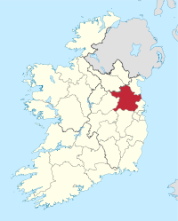
Basisdaten Staat: Irland Verwaltungssitz: Navan Provinz: Leinster irischer Name: An Mhí Fläche: 2335 km² Einwohner: 184.034 (2011) Kfz-Kennzeichen: MH Meath (irisch: An Mhí ) ist eine Grafschaft (county) in der Republik Irland. Der irische Name bedeutet "Mitte".
Inhaltsverzeichnis
Geografie
Die Grafschaft liegt in der zentralirischen Ebene und besteht fast ausschließlich aus Weideland.
Geschichte
Aus der Frühgeschichte sind hier gut erhaltene Megalithanlagen der Boynekultur zu finden. Die Gründung des alten Königssitzes Tara geht auf die frühgeschichtliche Epoche zurück. Im frühen Mittelalter war Meath eines der irischen Königreiche und umfasste das Gebiet des heutigen Meath und Westmeath sowie Teile von Cavan und Longford. Zwischen 100 und 565 war Meath mit Connacht vereinigt. 1172 wurde das County von König Heinrich II. von England als Lehen an Hugh de Lacy gegeben.
Wirtschaft
In der Landwirtschaft herrschen Rinder- und Schafzucht vor. Daneben gibt es Bekleidungs- und Möbelindustrie.
Politik
Meath entsendet sechs Abgeordnete in das irische Parlament (Dáil Éireann); die letzte Wahl fand 2011 statt.
Die Sitzverteilung im County Council nach der Kommunalwahl vom 5. Juni 2009:
Partei Sitze Fine Gael 11 Fianna Fáil 8 Labour Party 4 Sinn Féin 1 Parteilose 5 Städte
- Navan
- Athboy
- Dunboyne
- Ratoath
- Donaghmore
- Julianstown
- Trim
- Kells
- Oldcastle
- Dunshaughlin
- Duleek
- Slane
- Stamullin
Sehenswürdigkeiten
 Hill of Tara
- Brú na Bóinne ("Boyne Palast"): drei megalithische Hügelgräber (Newgrange, Knowth, Dowth)
- Hill of Tara: Reste eines Hügelgrabs und Ringforts – Tara war laut Legende der Sitz der Irischen Hochkönige.
- Loughcrew oder Sliabh na Caillighe: Megalithischer Friedhof
- Fourknocks Passage tomb
- Athcarne Castle
- Trim Castle
Persönlichkeiten
- Wallis Bird, Musikerin
- Pierce Brosnan, Schauspieler, wurde in Navan geboren.
- John Bruton, ehemaliger Taoiseach (Ministerpräsident) und derzeit Botschafter der Europäischen Union in den Vereinigten Staaten
- Siobhan Fahey, Sängerin (Bananarama; Shakespear’s Sister), wurde in Dunshaughlin geboren.
- Shane Horgan, Rugby-Union-Nationalspieler, wurde in Bellewstown geboren.
Weblinks
- Brú na Bóinne ("Boyne Palast" in der englischsprachigen Wikipedia)
 Commons: County Meath – Album mit Bildern und/oder Videos und Audiodateien
 Grafschaften (Countys) der Republik Irland
Carlow | Cavan | Clare | Cork | Donegal | Dublin (Fingal | Dun Laoghaire-Rathdown | South Dublin | Stadt Dublin) | Galway | Kerry | Kildare | Kilkenny | Laois | Leitrim | Limerick | Longford | Louth | Mayo | Meath | Monaghan | Offaly | Roscommon | Sligo | Tipperary | Waterford | Westmeath | Wexford | Wicklow
Wikimedia Foundation.
Schlagen Sie auch in anderen Wörterbüchern nach:
County Meath — Contae na Mí Coat of arms Motto: Tré Neart … Wikipedia
County Meath — Comté de Meath Comté de Meath Contae na Mí … Wikipédia en Français
Ashbourne, County Meath — Infobox Irish Place name = Ashbourne gaeilge = Cill Dhéagláin crest motto = map pin coords = left: 100px; top: 82px north coord = 53.512296 west coord = 6.398335 irish grid = O060525 area = elevation = 73 m (240 ft) province = Leinster county =… … Wikipedia
Oldcastle, County Meath — Oldcastle An Seanchaisléan Town … Wikipedia
Trim, County Meath — Infobox Irish Place name = Trim gaeilge = Baile Átha Troim crest motto = map pin coords = left: 60px; top: 78px north coord = 53.552241 west coord = 6.793413 irish grid = N800567 area = elevation = 61 m (200 ft) province = Leinster county =… … Wikipedia
Clonard, County Meath — This article is about Clonard, County Meath. For other uses, see Clonard. Clonard Cluain Ioraird Town … Wikipedia
Gormanston, County Meath — Gormanston Baile Mhic Gormáin Town … Wikipedia
Kells, County Meath — Infobox Irish Place name = Kells gaeilge = Ceanannas crest motto = map pin coords = left: 51px; top: 44px north coord = 53.727998 west coord = 6.877613 irish grid = N738759 area = elevation = province = Leinster county = County Meath town pop = 5 … Wikipedia
Moylagh, County Meath — Moylagh (Irish: Maigh Locha) is part of the parish of Oldcastle in the northwest of County Meath, Ireland. The parish is small but has received an influx of new residents in the past few years, mainly from Dublin and Eastern Europe. Moylagh has a … Wikipedia
Longwood, County Meath — Infobox Irish Place name = Longwood gaeilge = Maigh Dearmhaí crest motto = map pin coords = left: 50px; top:90px north coord = 53.4545 west coord = 6.9252 irish grid = N710455 area = elevation = 70 m province = Leinster county = County Meath town … Wikipedia
County Meath


18+
© Academic, 2000-2024
- Kontaktieren Sie uns: Unterstützung, Werbung
Wörterbücher Export, schritte mit PHP, Joomla, Drupal, WordPress, MODx.