- County Offaly
-
County Offaly
Contae Uíbh FhailíKarte 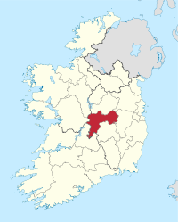
Basisdaten Staat: Irland Verwaltungssitz: Tullamore Provinz: Leinster irischer Name: Uíbh Fhailí Fläche: 1990 km² Einwohner: 76.806 (2011) Kfz-Kennzeichen: OY  Flagge der Grafschaft Offaly[1]
Offaly (irisch Uíbh Fhailí) ist eine Grafschaft (county) in der irischen Provinz Leinster, die an die Grafschaften Galway, Roscommon, Westmeath, Meath, Kildare, Laois und Tipperary grenzt.
Inhaltsverzeichnis
Geografie
Die Grafschaft besteht weitestgehend aus einer Ebene, die im Westen vom Fluss Shannon begrenzt wird. Nur im Süden erheben sich die Slieve Bloom Mountains. Durch die Grafschaft zieht sich der Grand Canal, der Dublin mit Ballinasloe verbindet.
Geschichte
Im Mittelalter lag hier das Fürstentum Offaly, das neben dem heutigen County auch Teile von Tipperary, Laois und Kildare umfasste. Dieses Fürstentum stand lange unter der Herrschaft des Hauses O’Connor und kam im 16. Jahrhundert an die englische Krone. 1556 wurde die Grafschaft unter dem Namen King's County eingerichtet.
Wirtschaft
Die Landwirtschaft besteht aus Rinder-, Schaf- und Schweinezucht sowie dem Anbau von Weizen und Braugerste. Es existieren Textilindustrie, Brennereien, sowie Möbelherstellung und Juteverarbeitung.
Politik
Offaly bildet zusammen mit dem County Laois einen Wahlkreis, der fünf Abgeordnete in das irische Parlament (Dáil Éireann) entsendet; die letzte Wahl fand 2011 statt.
Die Sitzverteilung im County Council nach der Kommunalwahl vom 5. Juni 2009:
Partei Sitze Fianna Fáil 9 Fine Gael 6 Parteilose 6 Städte
 Birr Castle
Sehenswürdigkeiten
- Durrow High Cross & Well
- Clonmacnoise, Klosterruine
- Dowris-Hort
- Leap Castle
- Clonfinlough-Stein
Persönlichkeiten
- Brian Cowen (* 1960), Minister, Tánaiste, seit Mai 2008 Taoiseach und Vorsitzender der Fianna Fáil
Einzelnachweis
 Grafschaften (Countys) der Republik Irland
Carlow | Cavan | Clare | Cork | Donegal | Dublin (Fingal | Dun Laoghaire-Rathdown | South Dublin | Stadt Dublin) | Galway | Kerry | Kildare | Kilkenny | Laois | Leitrim | Limerick | Longford | Louth | Mayo | Meath | Monaghan | Offaly | Roscommon | Sligo | Tipperary | Waterford | Westmeath | Wexford | Wicklow
Wikimedia Foundation.
Schlagen Sie auch in anderen Wörterbüchern nach:
County Offaly — Contae Uíbh Fhailí Coat of arms Motto … Wikipedia
Croghan, County Offaly — Croghan Cruachán Town … Wikipedia
Durrow, County Offaly — Durrow An Darú Town … Wikipedia
Edenderry, County Offaly — Infobox Irish Place name = Edenderry gaeilge = Eadán Doire crest motto = Esto Fideles The Faithful map pin coords = left: 120px; top: 25px north coord = 53.2667 west coord = 7.5000 irish grid = N335248 area = elevation = 83 m province = Leinster… … Wikipedia
Cloghan, County Offaly — Cloghan An Clochán Town … Wikipedia
Blue Ball, County Offaly — Infobox Irish Place name = Blue Ball gaeilge = An Phailís crest motto = map pin coords = left: 78px; top: 35px north coord = west coord = irish grid = area = elevation = province = Leinster county = Offaly town pop = rural pop = census yr = web … Wikipedia
Doon, County Offaly — Doon Crossroads Doon (Irish: An Clochán) is a hamlet in County Offaly, Ireland, located at the intersection of the N62 National secondary road and the R444 regional road … Wikipedia
Brosna, County Offaly — Infobox Irish Place name = Brosna gaeilge = temp crest motto = map pin coords = left: 78px; top: 35px north coord = west coord = irish grid = area = elevation = province = Leinster county = Offaly town pop = rural pop = census yr = web = Brosna… … Wikipedia
Rahan, County Offaly — Rahan (Irish: Raithean ) is a parish/village, associated with Mochuda (also known as St. Carthage), which is located on the banks of the Grand Canal about 5 miles from Tullamore, in County Offaly, Ireland. St. Mochuda, or Carthage founded his… … Wikipedia
Rhode, County Offaly — Rhode ( Ród in Irish) is a village in County Offaly in Ireland. It is situated on the R400 at its junction with the R441 which leads to Edenderry, the nearest town, located 12 km east of Rhode.The village is on an island of high ground surrounded … Wikipedia
County Offaly


18+
© Academic, 2000-2024
- Kontaktieren Sie uns: Unterstützung, Werbung
Wörterbücher Export, schritte mit PHP, Joomla, Drupal, WordPress, MODx.