- County Dublin
-
County Dublin
Contae Bhaile Átha CliathKarte 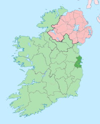
Basisdaten Staat: Irland Verwaltungssitz: Dublin Provinz: Leinster irischer Name: Áth Cliath Fläche: 921 km² Einwohner: 1.270.603 (2011) Kfz-Kennzeichen: D  Lage der Stadt Dublin in Irlands heutiger Verwaltungsstruktur
Dublin (irisch Baile Átha Cliath) war bis 1994 eine Grafschaft (county) in der Republik Irland.
Mit Wirkung vom 1. Januar 1994 wurde das County Dublin per Gesetz aufgelöst und auf die neuen Countys Fingal (Sitz: Swords), Dún Laoghaire-Rathdown (Sitz: Dún Laoghaire) und South Dublin (Sitz: Tallaght) sowie die nun selbstständige Stadt Dublin aufgeteilt. Diese Neugliederung ist allerdings im öffentlichen Bewusstsein nur eingeschränkt angekommen; der Begriff "County Dublin" ist immer noch häufig zu hören und zu lesen.
Inhaltsverzeichnis
Wirtschaft
Die Landwirtschaft besteht in der Hauptsache aus Rinder- und Schafzucht. Die Stadt Dublin ist das wirtschaftliche Zentrum des Landes. Hier konzentrieren sich Industrie, Handel, Banken und Versicherungen.
Städte
Sehenswürdigkeiten
- Ballyedmonduff Wedge tomb
- Brenanstown
- Kilmashogue
- Kiltiernan Portal tomb
Weblinks
 Commons: County Dublin – Sammlung von Bildern, Videos und Audiodateien
 Grafschaften (Countys) der Republik Irland
Carlow | Cavan | Clare | Cork | Donegal | Dublin (Fingal | Dun Laoghaire-Rathdown | South Dublin | Stadt Dublin) | Galway | Kerry | Kildare | Kilkenny | Laois | Leitrim | Limerick | Longford | Louth | Mayo | Meath | Monaghan | Offaly | Roscommon | Sligo | Tipperary | Waterford | Westmeath | Wexford | Wicklow
Wikimedia Foundation.
Schlagen Sie auch in anderen Wörterbüchern nach:
County Dublin — For other uses, see Dublin (disambiguation). County Dublin Contae Bhaile Átha Cliath Coat of arms … Wikipedia
List of subdivisions of County Dublin — County Dublin has been traditionally divided into a series of smaller areas called baronies, civil parishes and townlands. The only formal recognition of Dublin as a County is held by the Gaelic Athletic Association. In 1994 the County and its… … Wikipedia
North County Dublin (UK Parliament constituency) — For the 1969–1981 constituency, see Dublin County North (Dáil Éireann constituency). North Dublin Former County constituency for the House of Commons 1885 (1885)–1922 … Wikipedia
South County Dublin (UK Parliament constituency) — For the 1969–1981 constituency, see Dublin County South (Dáil Éireann constituency). South Dublin Former County constituency for the House of Commons 1885 (1885)–1922 … Wikipedia
List of townlands of County Dublin — Ireland portal List of townlands in County Dublin This is a sortable table of the approximately 1,090 townlands in County Dublin, Ireland. [1] … Wikipedia
Monkstown, County Dublin — Monkstown Baile na Manach Suburb of Dublin … Wikipedia
Swords, County Dublin — Infobox Irish Place name = Swords gaeilge = Sord Cholm Cille crest motto = map pin coords = left: 98px; top: 40px north coord = 53.4597 west coord = 6.2181 irish grid = O184469 area = elevation = 3m province = Leinster county = Fingal town pop =… … Wikipedia
North County Dublin — is an unofficial geographical description for an area north of Dublin City in Ireland. The title North County Dublin has been in use by Dubliners, typically from the northside of the city, since the early 20th Century. It describes the area… … Wikipedia
Lusk, County Dublin — Lusk (Irish: Lusca ) is a large village in Ireland located km to mi | 23 | abbr=yes | precision=0 north of Dublin city centre. The name Lusk dates back to the time of Saint MacCullin, who founded a church there in the 450s. He is reputed to have… … Wikipedia
South County Dublin — may refer to:* The County of South Dublin, created in 1983 * Dublin County South (Dáil Éireann constituency) (1969 ndash;1981) … Wikipedia
County Dublin


18+
© Academic, 2000-2024
- Kontaktieren Sie uns: Unterstützung, Werbung
Wörterbücher Export, schritte mit PHP, Joomla, Drupal, WordPress, MODx.