- Ballymena (Borough)
-
Ballymena Borough
Buirg an Bhaile Mheánaigh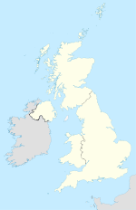

Ballymena Borough 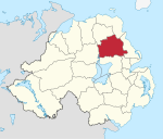
Geografie Traditionelle Grafschaft County Antrim Fläche 632 km² Verwaltungssitz Ballymena ISO 3166-2 GB-BLA Demografie Bevölkerung 62.700 (2008) Dichte 99 Ew./km² Konfessionen Protestanten: 76,3 %
Katholiken: 21,0 %Homepage
www.ballymena.gov.ukBallymena (irisch: An Baile Meánach) ist einer der 26 nordirischen Districts. Der District, dessen Gebiet in der traditionellen Grafschaft Antrim liegt, wurde 1973 eingerichtet und besitzt den Status eines Borough. Bedeutende Orte im Borough sind die Stadt Ballymena, die auch Verwaltungssitz ist, sowie Broughshane, Cullybackey, Galgorm, Ahoghill und Portglenone.
Ballymena Borough Council
Die Wahl zum Ballymena Borough Council am 11. Mai 2011 hatte folgendes Ergebnis:[1]
Partei Ergebnis 2011 Veränderung zu 2006 Sitze Stimmen Sitze Stimmen Democratic Unionist Party (DUP) 12 45,9 % -2 -9,2 % Ulster Unionist Party (UUP) 4 16,3 % -1 -5,2 % Traditional Unionist Voice 2 13,5 % 2 13,5 % Social Democratic and Labour Party (SDLP) 2 8,5 % -1 -1,8 % Sinn Féin 2 8,3 % 1 0,7 % Alliance Party 1 1,7 % 1 0,2 % Sonstige 0 0,0 % 0 -0,4 % Unabhängige 1 5,7 % 0 2,3 % Siehe auch
Einzelnachweise
- ↑ Wahlergebnis bei BBC News (Abgerufen am 26. Juli 2011)

Antrim | Ards | Armagh | Ballymena | Ballymoney | Banbridge | Belfast | Carrickfergus | Castlereagh | Coleraine | Cookstown | Craigavon | Derry | Down | Dungannon and South Tyrone | Fermanagh | Larne | Limavady | Lisburn | Magherafelt | Moyle | Newry and Mourne | Newtownabbey | North Down | Omagh | Strabane
Wikimedia Foundation.
Schlagen Sie auch in anderen Wörterbüchern nach:
Ballymena Borough Council — NI district district name = Ballymena Borough alt name = Comhairle Baile an Bhaile Meánaigh district area rank = 8th district area = 632 district HQ = Ballymena district iso = GB BLA district ons = 95G protestant pc = 76.3% catholic pc = 21.0%… … Wikipedia
List of Areas of Special Scientific Interest in Ballymena Borough — NOTOC This is a list of the Areas of Special Scientific Interest (ASSIs) in the Ballymena Borough area in Northern Ireland, United Kingdom.In Northern Ireland the body responsible for designating ASSIs is the Environment and Heritage Service a… … Wikipedia
Ballymena — Infobox UK place official name= Ballymena irish name= An Baile Meánach scots name= local name= static static image caption= map type= Northern Ireland latitude= 54.86 longitude= 6.28 belfast distance=convert|28|mi|0 SE population= 28,717 (2001… … Wikipedia
Ballymena railway station — Infobox NI station name = Ballymena locale = Ballymena borough = Ballymena Borough Council years = 1855 1981 2008 events = Original Station opened Current station opened Station refurbished platforms = 2 usage0405 = Ballymena railway station… … Wikipedia
The Showgrounds (Ballymena) — Ballymena Showgrounds Généralités Adresse Ballymena Coordonnées … Wikipédia en Français
The Showgrounds (Ballymena) — Infobox Stadium stadium name = Ballymena Showgrounds nickname = location = Ballymena, Northern Ireland broke ground = opened = 1903 last renovated = 2002 owner = Ballymena Borough Council surface = Grass pitch former names = none tenants =… … Wikipedia
District de Ballymena — 54°51′47.78″N 6°17′3.36″O / 54.8632722, 6.2842667 … Wikipédia en Français
Carrickfergus Borough Council — NI district district name = Carrickfergus Borough alt name = Comhairle Baile Charraig Fheargais district area rank = 25th district area = 82 district HQ = Carrickfergus district iso = GB CKF district ons = 95V protestant pc = 85.1% catholic pc =… … Wikipedia
Larne Borough Council — NI district district name = Larne Borough alt name = Comhairle Baile Latharna district area rank = 21st district area = 336 district HQ = Larne district iso = GB LRN district ons = 95F protestant pc = 71.7% catholic pc = 25.2% web address =… … Wikipedia
Ballymoney (borough) — Ballymoney Borough Geography Area Total Ranked 17th of 26 418 km² … Wikipedia
Ballymena (Borough)


18+
© Academic, 2000-2024
- Kontaktieren Sie uns: Unterstützung, Werbung
Wörterbücher Export, schritte mit PHP, Joomla, Drupal, WordPress, MODx.