- Strabane (District)
-
Strabane District
Ceantar an tSratha Báin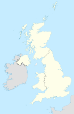

Strabane District 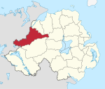
Geografie Traditionelle Grafschaft County Tyrone Fläche 862 km² Verwaltungssitz Strabane ISO 3166-2 GB-STB Demografie Bevölkerung 39.600 (2008) Dichte 46 Ew./km² Konfessionen Protestanten 33,3 %
Katholiken 66,2 %Homepage
www.strbanedc.org.ukStrabane (irisch An Srath Bán) ist einer der 26 nordirischen Districts. Der District, dessen Gebiet in der traditionellen Grafschaft Tyrone liegt, wurde 1973 eingerichtet. Bedeutende Orte sind der Verwaltungssitz Strabane sowie Plumbridge, Newtownstewart, Donemana, Sion Mills und Castlederg.
Strabane Council
Die Wahl zum Strabane Council am 11. Mai 2011 hatte folgendes Ergebnis:[1]
Partei Ergebnis 2011 Veränderung zu 2006 Sitze Stimmen Sitze Stimmen Sinn Féin 8 39,3 % 0 -2,4 % Democratic Unionist Party (DUP) 4 23,2 % 0 1,0 % Ulster Unionist Party (UUP) 1 13,6 % -1 -0,5 % Social Democratic and Labour Party (SDLP) 1 9,2 % -1 -6,7 % Unabhängige 2 10,8 % 1 5,2 % Sonstige 0 3,8 % 0 3,5 % Siehe auch
Einzelnachweise
- ↑ Wahlergebnis bei BBC News (Abgerufen am 26. Juli 2011)

Antrim | Ards | Armagh | Ballymena | Ballymoney | Banbridge | Belfast | Carrickfergus | Castlereagh | Coleraine | Cookstown | Craigavon | Derry | Down | Dungannon and South Tyrone | Fermanagh | Larne | Limavady | Lisburn | Magherafelt | Moyle | Newry and Mourne | Newtownabbey | North Down | Omagh | Strabane
Wikimedia Foundation.
Schlagen Sie auch in anderen Wörterbüchern nach:
Strabane District — Admin ASC 2 Code Orig. name Strabane District Country and Admin Code GB.NIR.T4 GB … World countries Adminstrative division ASC I-II
Strabane District Council — NI district district name = Strabane District alt name = Comhairle Ceantair an tSratha Báin Stràbane Destrick Cooncil district area rank = 4th district area = 862 district HQ = Strabane district iso = GB STB district ons = 95J protestant pc =… … Wikipedia
Derry City and Strabane District Council — is a proposed Northern Irish local government district. Under the latest decision by the Review of Public Administration the district would be created by merging Derry City Council and Strabane District Council. The new district will cover parts… … Wikipedia
Strabane — Infobox Irish Place|thumb|left|name = Strabane gaeilge = An tSraith Bhán crest motto = Concordia Crescit Let Goodwill Increase map pin coords = left: 43px; top: 53px north coord = 54.833333 west coord = 7.47 province = Ulster county = County… … Wikipedia
District de Strabane — 54°30′0″N 7°16′12″O / 54.5, 7.27 … Wikipédia en Français
Strabane — Irish An Srath Bán Town, seat, and district (pop., 1995 est.: 36,000), Northern Ireland. Strabane is composed of river valleys, rolling lowlands, and moorlands of the Sperrin Mountains. Originally inhabited by the O Neill clan of Ulster, the… … Universalium
Strabane — Hauptstraße in Strabane Strabane (irisch: An Srath Bán) ist eine Stadt im County Tyrone in Nordirland (Vereinigtes Königreich). Die Stadt liegt unmittelbar an der Grenze zum County Donegal und damit zur Republik Irland. Inhaltsverzei … Deutsch Wikipedia
District de Cookstown — Cookstown District Council (en) Comhairle Ceantair na Coirre Críochaí (ga) Districk Cooncil o Cookestoun ( … Wikipédia en Français
District de Carrickfergus — Carrickfergus Borough Council (en) Comhairle Baile Charraig Fheargais (ga) … Wikipédia en Français
Strabane Canal — Übersichttafel zum Strabane Canal. Der Strabane Canal ist eine Wasserstraße im County Tyrone in Nordirland. 1791 wurde die Konstruktion eines 6,5 Kilometer langen Kanals vom Fluß Foyle bei Leck, rund 15 Kilometer stromaufwärts von Derry, nach… … Deutsch Wikipedia
Strabane (District)


18+
© Academic, 2000-2024
- Kontaktieren Sie uns: Unterstützung, Werbung
Wörterbücher Export, schritte mit PHP, Joomla, Drupal, WordPress, MODx.