- Dungannon and South Tyrone
-
Dungannon and South Tyrone
Buirg Dhún Geanainn agus Thír Eoghain Theas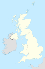

Dungannon and South Tyrone 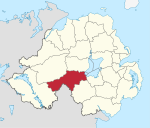
Geografie Traditionelle Grafschaften County Tyrone
County ArmaghFläche 784 km² Verwaltungssitz Dungannon ISO 3166-2 GB-DGN Demografie Bevölkerung 56.400 (2009) Dichte 72 Ew./km² Konfessionen Protestanten 38,2 %
Katholiken 60,8 %Homepage
www.dungannon.gov.ukDungannon and South Tyrone (irisch Dún Geanainn agus Tír Eoghain Theas) ist einer der 26 nordirischen Districts und umfasst einen großen Teil der traditionellen Grafschaft Tyrone sowie einen kleinen Teil der Grafschaft Armagh. Im Distrikt, der 1973 gebildet wurde und den Status eines Borough besitzt, liegen neben dem Verwaltungssitz Dungannon unter anderem die Orte Coalisland, Augher, Clogher, Fivemiletown, Ballygawley, Caledon, Aughnacloy, Benburb, und Moy. Von 1973 bis 1999 hieß der District nur Dungannon.
In dem District leben etwa 56.400 Einwohner; als katholisch bezeichnen sich gut 60 %, als protestantisch etwa 38 %.
Inhaltsverzeichnis
Dungannon and South Tyrone Council
Die Wahl zum Dungannon and South Tyrone Council am 11. Mai 2011 hatte folgendes Ergebnis:[1]
Partei Ergebnis 2011 Veränderung zu 2006 Sitze Stimmen Sitze Stimmen Sinn Féin 8 34,5 % -1 -5,2 % Democratic Unionist Party (DUP) 6 21,8 % 1 -2,5 % Ulster Unionist Party (UUP) 4 18,8 % 0 1,2 % Social Democratic and Labour Party (SDLP) 3 13,9 % -1 -0,8 % Traditional Unionist Voice 0 1,7 % 0 1,7 % Alliance Party 0 0,9 % 0 0,9 % Unabhängige 1 8,4 % 1 4,7 % Verkehr
Der Motorway M1 von Belfast führt bis Dungannon und setzt sich in der Fernstraße A4 fort. Die Fernstraße A5 von Omagh nach Monaghan in der Republik Irland kreuzt die A4 bei Ballygawley. Eine Eisenbahnverbindung gibt es nicht.
Tourismus
Coalisland hat ein Heimatmuseum (Cornmill Heritage Centre) und bei Carnteel erinnert ein Haus an die Vorfahren des US-amerikanischen Präsidenten Ulysses S. Grant. Östlich von Dungannon liegt der Peatlands Country Park, westlich der Parkanaur Forest Park.
Siehe auch
Einzelnachweise
- ↑ Wahlergebnis bei BBC News (Abgerufen am 26. Juli 2011)

Antrim | Ards | Armagh | Ballymena | Ballymoney | Banbridge | Belfast | Carrickfergus | Castlereagh | Coleraine | Cookstown | Craigavon | Derry | Down | Dungannon and South Tyrone | Fermanagh | Larne | Limavady | Lisburn | Magherafelt | Moyle | Newry and Mourne | Newtownabbey | North Down | Omagh | Strabane
Wikimedia Foundation.
Schlagen Sie auch in anderen Wörterbüchern nach:
Dungannon and South Tyrone Borough Council — Coordinates: 54°25′30″N 7°05′46″W / 54.425°N 7.096°W / 54.425; 7.096 … Wikipedia
District de Dungannon and South Tyrone — 54° 25′ 30″ N 7° 05′ 46″ W / 54.425, 7.096 … Wikipédia en Français
Fermanagh and South Tyrone (UK Parliament constituency) — UK constituency infobox alt Name = Fermanagh and South Tyrone Type = County Entity = Northern Ireland DivisionType = Districts Division = Fermanagh, Dungannon and South Tyrone Year = 1950 MP = Michelle Gildernew Party = Sinn Féin EP = Northern… … Wikipedia
Fermanagh and South Tyrone (Assembly constituency) — Northern Ireland Assembly constituency infobox Name = Fermanagh and South Tyrone Type = County Year = 1973 AM =6 Districts = Fermanagh, Dungannon and South TyroneFermanagh and South Tyrone is a constituency in the Northern Ireland Assembly.The… … Wikipedia
Fermanagh and South Tyrone by-election, August 1981 — The Fermanagh and South Tyrone by election, August 1981 was the second by election in the same year, held in Fermanagh and South Tyrone on August 20 1981. It was seen by many as a rerun of the earlier contest in April. The by election was caused… … Wikipedia
Fermanagh and South Tyrone by-election, April 1981 — The by election held in Fermanagh and South Tyrone on April 9 1981 is considered by many to be the most significant by election held in Northern Ireland since the beginning of the Troubles. It saw the first victory for the militant Republican… … Wikipedia
Dungannon and District Motorcycle Club — The Dungannon and District Motorcycle Club was formed in 1922, in Dungannon, County Tyrone, Northern Ireland, and held a number of “bike runs”, an athletic sports day and supported their local racers in its year of inception. In the club’s second … Wikipedia
South Tyrone (Northern Ireland Parliament constituency) — Northern Ireland Parliament constituency infobox Name = South Tyrone Type = County Start = 1929 End = 1972 EM = First past the postSouth Tyrone was a constituency of the Northern Ireland Parliament.BoundariesSouth Tyrone was a county constituency … Wikipedia
Dungannon — For the town in Virginia, see Dungannon, Virginia. For the thoroughbred racehorse, see Dungannon (horse). For the former barony, see Dungannon (barony). Coordinates: 54°30′N 6°46′W / … Wikipedia
Dungannon — Die Irish Street in Dungannon. Dungannon (irisch: Dún Geanainn) ist eine Stadt im County Tyrone in Nordirland. Es ist die drittgrößte Stadt des Countys und hatte beim Census 2001 11.139 Einwohner. Dungannon ist Verwaltungssitz des Districts… … Deutsch Wikipedia
Dungannon and South Tyrone


18+
© Academic, 2000-2024
- Kontaktieren Sie uns: Unterstützung, Werbung
Wörterbücher Export, schritte mit PHP, Joomla, Drupal, WordPress, MODx.