- Magherafelt (District)
-
Magherafelt District
Ceantar Mhachaire Fíolta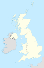

Magherafelt District 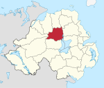
Geografie Traditionelle Grafschaft County Londonderry Fläche 573 km² Verwaltungssitz Magherafelt ISO 3166-2 GB-MFT Demografie Bevölkerung 43.800 (2008) Dichte 76 Ew./km² Konfessionen Protestanten: 34,8 %
Katholiken: 64,1 %Homepage
www.magherafelt.gov.ukMagherafelt (irisch Machaire Fíolta) ist einer der 26 nordirischen Districts. Der District, dessen Gebiet in der traditionellen Grafschaft Londonderry liegt, wurde 1973 eingerichtet. Bedeutende Orte im Borough sind die Stadt Magherafelt, die auch Verwaltungssitz ist, sowie Bellaghy und Castledawson.
Magherafelt Council
Die Wahl zum Magherafelt Council am 11. Mai 2011 hatte folgendes Ergebnis:[1]
Partei Ergebnis 2011 Veränderung zu 2006 Sitze Stimmen Sitze Stimmen Sinn Féin 9 48,4 % 1 1,7 % Democratic Unionist Party (DUP) 3 16,3 % 0 -6,9 % Social Democratic and Labour Party (SDLP) 2 15,9 % 0 -2,6 % Ulster Unionist Party (UUP) 2 9,8 % 0 3,6 % Traditional Unionist Voice 0 5,3 % 0 5,3 % Sonstige 0 4,2 % 0 4,2 % Siehe auch
Einzelnachweise
- ↑ Wahlergebnis bei BBC News (Abgerufen am 26. Juli 2011)

Antrim | Ards | Armagh | Ballymena | Ballymoney | Banbridge | Belfast | Carrickfergus | Castlereagh | Coleraine | Cookstown | Craigavon | Derry | Down | Dungannon and South Tyrone | Fermanagh | Larne | Limavady | Lisburn | Magherafelt | Moyle | Newry and Mourne | Newtownabbey | North Down | Omagh | Strabane
Wikimedia Foundation.
Schlagen Sie auch in anderen Wörterbüchern nach:
Magherafelt District — Admin ASC 2 Code Orig. name Magherafelt District Country and Admin Code GB.NIR.S7 GB … World countries Adminstrative division ASC I-II
Magherafelt District Council — Coordinates: 54°45′07″N 6°36′04″W / 54.752°N 6.601°W / 54.752; 6.601 … Wikipedia
Magherafelt — irisch Machaire Fíolta Koordinaten 54° … Deutsch Wikipedia
Magherafelt — District (pop., 2001: 39,780), central Northern Ireland. It is bounded by the River Bann, Lake Neaghon, and the Sperrin Mountains. It was formerly part of County Londonderry but was organized as a separate district in 1973. The town of… … Universalium
Magherafelt — Coordinates: 54°45′N 6°37′W / 54.75°N 6.61°W / 54.75; 6.61 … Wikipedia
District de Magherafelt — 54° 45′ 07″ N 6° 36′ 04″ W / 54.752, 6.601 … Wikipédia en Français
District de Carrickfergus — Carrickfergus Borough Council (en) Comhairle Baile Charraig Fheargais (ga) … Wikipédia en Français
District de Cookstown — Cookstown District Council (en) Comhairle Ceantair na Coirre Críochaí (ga) Districk Cooncil o Cookestoun ( … Wikipédia en Français
District de Castlereagh — 54°35′N 5°52′W / 54.583, 5.867 … Wikipédia en Français
District d'Antrim — 54° 43′ 37″ N 6° 12′ 36″ W / 54.727, 6.210 … Wikipédia en Français
Magherafelt (District)


18+
© Academic, 2000-2024
- Kontaktieren Sie uns: Unterstützung, Werbung
Wörterbücher Export, schritte mit PHP, Joomla, Drupal, WordPress, MODx.