- Down (District)
-
Down District
Ceantar an Dúin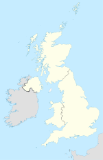

Down (District) 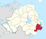
Geografie Traditionelle Grafschaft County Down Fläche 647 km² Verwaltungssitz Downpatrick ISO 3166-2 GB-DOW Demografie Bevölkerung 69.800 (2008) Dichte 108 Ew./km² Konfessionen Protestanten 35,5 %
Katholiken 61,9 %Homepage
www.downdc.gov.ukDown (irisch An Dún) ist einer der 26 nordirischen Districts und umfasst einen Teil der traditionellen Grafschaft Down. Im Distrikt, der 1973 gebildet wurde, liegen neben dem Verwaltungssitz Downpatrick die Orte Ardglass, Ballynahinch, Castlewellan, Clough, Crossgar, Dundrum, Killough, Killyleagh, Newcastle, Saintfield, Seaforde und Strangford.
Down Council
Die Wahl zum Down Council am 11. Mai 2011 hatte folgendes Ergebnis:[1]
Partei Ergebnis 2011 Veränderung zu 2006 Sitze Stimmen Sitze Stimmen Social Democratic and Labour Party (SDLP) 9 34,2 % -2 -3,3 % Sinn Féin 5 22,9 % 0 -0,2 % Democratic Unionist Party (DUP) 3 16,4 % 0 0,1 % Ulster Unionist Party (UUP) 3 13,2 % -1 -4,1 % Alliance Party 1 4,9 % 1 2,8 % Green Party 1 4,1 % 0 0,8 % Unabhängige 1 4,3 % 1 4,3 % Siehe auch
Einzelnachweise
- ↑ Wahlergebnis bei BBC News (Abgerufen am 26. Juli 2011)

Antrim | Ards | Armagh | Ballymena | Ballymoney | Banbridge | Belfast | Carrickfergus | Castlereagh | Coleraine | Cookstown | Craigavon | Derry | Down | Dungannon and South Tyrone | Fermanagh | Larne | Limavady | Lisburn | Magherafelt | Moyle | Newry and Mourne | Newtownabbey | North Down | Omagh | Strabane
Wikimedia Foundation.
Schlagen Sie auch in anderen Wörterbüchern nach:
Down District — Admin ASC 2 Code Orig. name Down District Country and Admin Code GB.NIR.R9 GB … World countries Adminstrative division ASC I-II
Down District Council — Coordinates: 54°21′07″N 5°43′52″W / 54.352°N 5.731°W / 54.352; 5.731 … Wikipedia
Newry City and Down District Council — is a proposed Northern Irish local government district. Under the latest decision by the Review of Public Administration the district would be created by merging Newry and Mourne District Council and Down District Council, and by transferring the … Wikipedia
Ards and North Down District — Council is a proposed Northern Irish local government district. Under the latest decision by the Review of Public Administration the district would be created by merging Ards Borough Council and North Down Borough Council. , though a small area… … Wikipedia
North Down District — Admin ASC 2 Code Orig. name North Down District Country and Admin Code GB.NIR.T2 GB … World countries Adminstrative division ASC I-II
Down — ([daʊn], engl. unten, herunter, herab, nieder) steht für: eine Grafschaft in Nordirland, siehe County Down einen District in Nordirland, siehe Down (District) eine Genommutation beim Menschen, siehe Down Syndrom (Trisomie 21) einen Quark, siehe… … Deutsch Wikipedia
Down — may refer to: Relative direction, where down is the direction towards the centre of gravity of a celestial object. Railroad directions, where down and up have locally significant meanings Down feather, a soft bird feather frequently used in… … Wikipedia
District de Down — 54° 21′ 07″ N 5° 43′ 52″ W / 54.352, 5.731 … Wikipédia en Français
Down — /down/, n. 1. a county in SW Northern Ireland. 311,876; 952 sq. mi. (2466 sq. km). Co. seat: Downpatrick. 2. an administrative district in this county. 49,500; 253 sq. mi. (654 sq. km). * * * I District (pop., 1999 est.: 63,800), Northern Ireland … Universalium
District of Columbia v. Heller — Supreme Court of the United States Argued March 18, 2008 Decided June … Wikipedia
Down (District)


18+
© Academic, 2000-2024
- Kontaktieren Sie uns: Unterstützung, Werbung
Wörterbücher Export, schritte mit PHP, Joomla, Drupal, WordPress, MODx.