- Middle Caicos
-
Middle Caicos (Grand Caicos) Position der Insel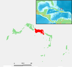
Gewässer Atlantischer Ozean Inselgruppe Caicos-Inseln Geographische Lage 21° 47′ N, 71° 44′ W21.788191666667-71.73454166666718Koordinaten: 21° 47′ N, 71° 44′ W 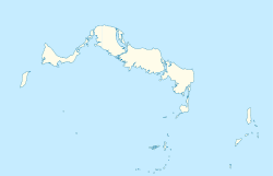

Länge 22,5 km Breite 5,5 km Fläche 124 km² Höchste Erhebung 18 m Einwohner 301 (2002)
2,4 Einw./km²Hauptort Conch Bar Middle Caicos, auch Grand Caicos genannt, ist die größte Insel der Caicos-Inseln und gehört zum britischen Überseegebiet der Turks- und Caicosinseln.
Die Insel ist von den benachbarten Inseln North Caicos und East Caicos nur durch schmale Meeresarme getrennt. Die Fläche von Middle Caicos beträgt 124 km². Hinzu kommen ausgedehnte Sumpf- und Wattgebiete an der Südküste, so dass die Landfläche bei Ebbe erheblich größer ist (gesamt ca. 294 km²). Die Nordküste besteht dagegen aus Kalksteinklippen und langen Sandstränden. Auf Middle Caicos befindet sich die größte Höhle der Turks- und Caicosinseln.
An der Nordküste befinden sich die Dörfer Lorimers, Bambarra und der Hauptort Conch Bar. Auf der Insel wohnen knapp 500 Menschen (Fortschreibung 2008, Volkszählung 2002: 301 Ortsansässige[1]). Damit ist Middle Caicos - abgesehen von der privaten Hotelinsel Parrot Cay - die am dünnsten besiedelte Insel der Caicos-Inseln.
Weblinks
Literatur
- H. E. Sadler, Marjorie Sadler, Karen Collins: Turks Islands Landfall. A History of the Turks & Caicos Islands. Marjorie E. Sadler, Grand Turk - Turks and Caicos Islands 1997, ISBN 976-8138-62-9.
Einzelnachweise
- ↑ Zensus der Turks- und Caicosinseln (englisch)

Turks-Inseln: Grand Turk | Salt Cay | Cotton Cay | East Cay | Gibbs Cay
Caicos-Inseln: West Caicos | Providenciales | Water Cay | Pine Cay | Stubbs Cay | Fort George Cay | Dellis Cay | Parrot Cay | North Caicos | Middle Caicos | East Caicos | South Caicos | Long Cay | Ambergris Cays
Wikimedia Foundation.
Schlagen Sie auch in anderen Wörterbüchern nach:
Middle Caicos — Middle Caicos, also Grand Caicos, is the largest island in the Turks and Caicos Islands. To the west, it is separated from North Caicos by Juniper Hole, and to the east, from East Caicos by Lorimer Creek, both narrow passages that can accommodate … Wikipedia
Middle Caicos — Géographie Pays Royaume Uni Archipel Îles Turques et Caïques … Wikipédia en Français
Middle Caicos Airport — IATA: MDS – ICAO: MBMC Summary Airport type Public Serves Middle Caicos, Turks and Caicos Islands El … Wikipedia
Caicos-Inseln — Karte der Turks und Caicosinseln Gewässer Atlantischer Ozean … Deutsch Wikipedia
Caicos del Este — Saltar a navegación, búsqueda La isla Caicos del Este (East Caicos) es la cuarta mayor en el territorio británico dependiente de Islas Turcas y Caicos. Pertenece al archipiélago de las Islas Caicos. Hacia el oeste está separada de la isla Caicos… … Wikipedia Español
Caicos Central — Caicos Central, también llamada Gran Caicos, (en inglés:Middle Caicos o Grand Caicos) es la isla más grande de las Islas Turcas y Caicos. Al oeste, está separada de Caicos del Norte por el Juniper Hole, y al este, de Caicos del Este por el… … Wikipedia Español
Caicos — ► Grupo de islas británicas en el extremo SE del archipiélago de las Bahamas; 4 315 h. Las principales son: North Caicos, South Caicos, Middle Caicos, East Caicos, West Caicos y Providenciales. (V. Turks.) … Enciclopedia Universal
Grand Caicos — Middle Caicos (Grand Caicos) Position der Insel Gewässer Atlantischer Ozean Inselgruppe … Deutsch Wikipedia
Grand Caicos — Middle Caicos Middle Caicos Carte des îles Turques et Caïques mettant en évidence Middle Caicos. Géographie Pays … Wikipédia en Français
Middle America (Americas) — For other uses, see Middle America (disambiguation). Middle America Area 2,728,827 km2 … Wikipedia
Middle Caicos


18+
© Academic, 2000-2024
- Kontaktieren Sie uns: Unterstützung, Werbung
Wörterbücher Export, schritte mit PHP, Joomla, Drupal, WordPress, MODx.