- Long Cay (Turks- und Caicosinseln)
-
Long Cay Lage der Insel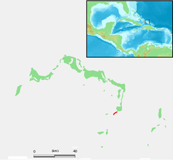
Gewässer Atlantischer Ozean Inselgruppe Caicos-Inseln Geographische Lage 21° 27′ 58″ N, 71° 33′ 31″ W21.466225-71.55849166666718Koordinaten: 21° 27′ 58″ N, 71° 33′ 31″ W 

Länge 4,8 km Breite 150 m Fläche 0,9 km² Höchste Erhebung 18 m Einwohner (unbewohnt) Hauptort --- Long Cay ist eine 4,8 Kilometer lange und im Durchschnitt nur 150 Meter breite unbewohnte Insel der Caicosinseln. Sie liegt 800 Meter südwestlich vor dem Küstenort Cockburn Harbour auf der Insel South Caicos.
Das schmale Long Cay liegt auf dem südöstlichen Außenriff der Turks- und Caicosinseln, ist karg bewachsen und durchweg felsig. An der mit 700 Meter breitesten Stelle ragen die schroffen Felsen bis 18 Meter über den Meeresspiegel hinaus.
Long Cay, das nahegelegene Middleton Cay und die Six Hill Cays sind beliebte Ausflugsziele von Hochseeanglern und Sporttauchern. Die Inseln gehören zum Nationalpark Admiral Cockburn Land & Sea National Park.
Weblinks

Turks-Inseln: Grand Turk | Salt Cay | Cotton Cay | East Cay | Gibbs Cay
Caicos-Inseln: West Caicos | Providenciales | Water Cay | Pine Cay | Stubbs Cay | Fort George Cay | Dellis Cay | Parrot Cay | North Caicos | Middle Caicos | East Caicos | South Caicos | Long Cay | Ambergris Cays
Wikimedia Foundation.
Schlagen Sie auch in anderen Wörterbüchern nach:
Turks- und Caicosinseln — Turks and Caicos Islands Turks und Caicosinseln … Deutsch Wikipedia
Turks & Caicos — Turks and Caicos Islands Turks und Caicosinseln … Deutsch Wikipedia
Caicosinseln — Caicos Inseln Karte der Turks und Caicosinseln Gewässer Atlantischer Ozean Anzahl der Inseln ca. 30 … Deutsch Wikipedia
Salt Cay (Turks-Inseln) — Salt Cay Satellitenbild von Salt Cay (links) Gewässer Atlantischer Ozean Inselgruppe … Deutsch Wikipedia
Turks-Inseln — Karte der Turks und Caicosinseln Gewässer Atlantischer Ozean … Deutsch Wikipedia
Fort George Cay — Vorlage:Infobox Insel/Wartung/Bild fehltVorlage:Infobox Insel/Wartung/Höhe fehlt Fort George Cay Gewässer Atlantischer Ozean Inselgruppe Caicos Inseln Geographische Lage … Deutsch Wikipedia
Pine Cay — Lage der Insel Gewässer Atlantischer Ozean Inselgruppe … Deutsch Wikipedia
Cotton Cay — Satellitenbild von Cotton Cay (Mitte) Gewässer Atlantischer Ozean Inselgruppe … Deutsch Wikipedia
Dellis Cay — Vorlage:Infobox Insel/Wartung/Bild fehltVorlage:Infobox Insel/Wartung/Höhe fehlt Dellis Cay Gewässer Atlantischer Ozean Inselgruppe Caicos Inseln Geographische Lage … Deutsch Wikipedia
Parrot Cay — Position der Insel Gewässer Atlantischer Ozean … Deutsch Wikipedia
Long Cay (Turks- und Caicosinseln)


18+
© Academic, 2000-2024
- Kontaktieren Sie uns: Unterstützung, Werbung
Wörterbücher Export, schritte mit PHP, Joomla, Drupal, WordPress, MODx.