- Vernon County (Wisconsin)
-
Verwaltung US-Bundesstaat: Wisconsin Verwaltungssitz: Viroqua Adresse des
Verwaltungssitzes:County Courthouse
Courthouse Annex
Viroqua, WI 54665-0000Gründung: 1851 Gebildet aus: Crawford County
Richland CountyVorwahl: 001 608 Demographie Einwohner: 29.773 (2010) Bevölkerungsdichte: 14,5 Einwohner/km² Geographie Fläche gesamt: 2.114 km² Wasserfläche: 56 km² Karte 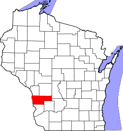
Website: www.co.vernon.wi.gov Vernon County[1] ist ein County im Bundesstaat Wisconsin der Vereinigten Staaten von Amerika. Bei der Volkszählung im Jahr 2010 hatte das County 29.773 Einwohner und eine Bevölkerungsdichte von 14,5 Einwohnern pro Quadratkilometer. Der Verwaltungssitz (County Seat) ist Viroqua.
Inhaltsverzeichnis
Geografie
Das County liegt im mittleren Südwesten von Wisconsin, grenzt im Westen an Iowa und Minnesota, getrennt durch den Mississippi River, der die natürliche Grenze darstellt. Das Vernom County hat eine Fläche von 2114 Quadratkilometern, wovon 56 Quadratkilometer Wasserfläche sind. Es grenzt an folgende Countys:
La Crosse County Monroe County Juneau County Houston County
(Minnesota)
Sauk County Allamakee County
(Iowa)Crawford County Richland County Geschichte
Das Vernon County wurde 1851 aus Teilen des Crawford County und des Richland County als Bad Axe County gebildet. Später wurde es umbenannt nach dem Landsitz Mount Vernon, der Heimat von George Washington.
Demografische Daten
Historische Einwohnerzahlen Census Einwohner ± in % 1900 28.351 — 1910 28.116 -0,8 % 1920 29.252 4 % 1930 28.537 -2 % 1940 29.940 5 % 1950 27.906 -7 % 1960 25.663 -8 % 1970 24.557 -4 % 1980 25.642 4 % 1990 25.617 -0,1 % 2000 28.056 10 % 2010 29.773 6 % 1900–1990[2] 2010[3]  Alterspyramide (2000) des Vernon County
Nach der Volkszählung im Jahr 2000 lebten im Vernon County 28.056 Menschen in 10.825 Haushalten. 7.501 Familien lebten im County. Die Bevölkerungsdichte betrug 14 Personen pro Quadratkilometer. Ethnisch betrachtet setzte sich die Bevölkerung zusammen aus 98,81 Prozent Weißen, 0,06 Prozent Afroamerikanern, 0,15 Prozent amerikanischen Ureinwohnern, 0,21 Prozent Asiaten, 0,01 Prozent Bewohnern aus dem pazifischen Inselraum und 0,27 Prozent aus anderen ethnischen Gruppen; 0,48 Prozent stammten von zwei oder mehr Ethnien ab. 0,66 Prozent der Bevölkerung waren spanischer oder lateinamerikanischer Abstammung, die verschiedenen der genannten Gruppen angehörten.
Von den 10.825 Haushalten hatten 31,5 Prozent Kinder unter 18 Jahren, die mit ihnen zusammen lebten. 58,7 Prozent davon waren verheiratete, zusammenlebende Paare, 6,8 Prozent waren allein erziehende Mütter. 30,7 Prozent waren keine Familien. 26,7 Prozent waren Singlehaushalte und in 13,7 Prozent lebten Menschen mit 65 Jahren oder älter. Die durchschnittliche Haushaltsgröße lag bei 2,55 und die durchschnittliche Familiengröße bei 3,11 Personen.
27,4 Prozent der Bevölkerung waren unter 18 Jahre alt, 6,8 Prozent zwischen 18 und 24, 25,3 Prozent zwischen 25 und 44, 23,5 Prozent zwischen 45 und 64, und 17,0 Prozent waren 65 Jahre oder älter. Das Durchschnittsalter betrug 39 Jahre. Auf 100 weibliche kamen statistisch 97,7 männliche Personen.[4]
Städte und Gemeinden
- Chaseburg
- Coon Valley
- De Soto
- Genoa
- Hillsboro
- La Farge
- Ontario
- Readstown
- Stoddard
- Viola1
- Viroqua
- Westby
1 - teilweise im Richland County
Einzelnachweise
- ↑ Vernon County im Geographic Names Information System des United States Geological Survey Abgerufen am 22. Februar 2011
- ↑ Auszug aus Census.gov Abgerufen am 28. Februar 2011
- ↑ United States Census 2010 Abgerufen am 13. April 2011
- ↑ Vernon County, Wisconsin Datenblatt mit den Ergebnissen der Volkszählung im Jahre 2000 bei factfinder.census.gov
Weblinks
-
 Commons: Vernon County, Wisconsin – Sammlung von Bildern, Videos und Audiodateien
 - Offizielle Webseite
- www.city-data.com

Liste der Countys in Wisconsin
Adams | Ashland | Barron | Bayfield | Brown | Buffalo | Burnett | Calumet | Chippewa | Clark | Columbia | Crawford | Dane | Dodge | Door | Douglas | Dunn | Eau Claire | Florence | Fond du Lac | Forest | Grant | Green | Green Lake | Iowa | Iron | Jackson | Jefferson | Juneau | Kenosha | Kewaunee | La Crosse | Lafayette | Langlade | Lincoln | Manitowoc | Marathon | Marinette | Marquette | Menominee | Milwaukee | Monroe | Oconto | Oneida | Outagamie | Ozaukee | Pepin | Pierce | Polk | Portage | Price | Racine | Richland | Rock | Rusk | Sauk | Sawyer | Shawano | Sheboygan | St. Croix | Taylor | Trempealeau | Vernon | Vilas | Walworth | Washburn | Washington | Waukesha | Waupaca | Waushara | Winnebago | Wood
Wikimedia Foundation.
Schlagen Sie auch in anderen Wörterbüchern nach:
Vernon County, Wisconsin — Infobox U.S. County county = Vernon County state = Wisconsin founded year = founded date = seat wl = Viroqua largest city wl = Viroqua area total sq mi = 816 area total km2 = 2114 area land sq mi = 795 area land km2 = 2059 area water sq mi = 22… … Wikipedia
National Register of Historic Places listings in Vernon County, Wisconsin — Buildings, sites, districts, and objects in Vernon County listed on the National Register of Historic Places See also: National Register of Historic Places listings in Wisconsin This National Park Service list is complete through NPS recent… … Wikipedia
Newton, Vernon County, Wisconsin — Newton, Wisconsin Unincorporated community … Wikipedia
Clinton, Vernon County, Wisconsin — Clinton, Wisconsin Town Location of Clinton, Vernon County, Wisconsin … Wikipedia
Christiana, Vernon County, Wisconsin — Christiana, Wisconsin Town Location of Christiana, Vernon County, Wisconsin … Wikipedia
Jefferson, Vernon County, Wisconsin — There are a few other places named Jefferson in Wisconsin. Infobox Settlement official name = Jefferson, Wisconsin settlement type = Town nickname = motto = imagesize = image caption = image mapsize = 250px map caption = Location of Jefferson,… … Wikipedia
Franklin, Vernon County, Wisconsin — Infobox Settlement official name = Franklin, Wisconsin settlement type = Town nickname = motto = imagesize = image caption = image mapsize = 250px map caption = Location of Franklin, Vernon County, Wisconsin mapsize1 = map caption1 = subdivision… … Wikipedia
Sterling, Vernon County, Wisconsin — Infobox Settlement official name = Sterling, Wisconsin settlement type = Town nickname = motto = imagesize = image caption = image mapsize = 250px map caption = Location of Sterling, Vernon County, Wisconsin mapsize1 = map caption1 = subdivision… … Wikipedia
Bergen, Vernon County, Wisconsin — Infobox Settlement official name = Bergen, Wisconsin settlement type = Town nickname = motto = imagesize = image caption = image mapsize = 250px map caption = Location of Bergen, Vernon County, Wisconsin mapsize1 = map caption1 = subdivision type … Wikipedia
Forest, Vernon County, Wisconsin — Infobox Settlement official name = Forest, Wisconsin settlement type = Town nickname = motto = imagesize = image caption = image mapsize = 250px map caption = Location of Forest, Vernon County, Wisconsin mapsize1 = map caption1 = subdivision type … Wikipedia
Vernon County (Wisconsin)


18+
© Academic, 2000-2024
- Kontaktieren Sie uns: Unterstützung, Werbung
Wörterbücher Export, schritte mit PHP, Joomla, Drupal, WordPress, MODx.