- Pulaski County (Georgia)
-
Verwaltung US-Bundesstaat: Georgia Verwaltungssitz: Hawkinsville Adresse des
Verwaltungssitzes:Pulaski County Administration
P.O. Box 29
Hawkinsville, Georgia, 31036-0029Gründung: 13. Dezember 1808 Gebildet aus: Laurens County Vorwahl: 001 478 Demographie Einwohner: 9588 (2000) Bevölkerungsdichte: 15 Einwohner/km² Geographie Fläche gesamt: 647 km² Wasserfläche: 6 km² Karte 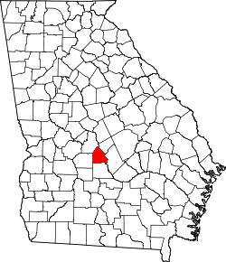
Website: hawkinsvillechamber.org Das Pulaski County[1] ist ein County im Bundesstaat Georgia der Vereinigten Staaten von Amerika. Der Verwaltungssitz (County Seat) ist Hawkinsville, benannt nach Colonel Benjamin Hawkins, einem Helden im Revolutionskrieg. Im Jahr 2000 hatte das County 9588 Einwohner und eine Bevölkerungsdichte von 15 Einwohnern pro Quadratkilometer.
Inhaltsverzeichnis
Geografie
Das County liegt etwas südlich des geographischen Zentrums von Georgia und hat eine Fläche von 647 Quadratkilometern, wovon 6 Quadratkilometer Wasseroberfläche sind; es grenzt im Uhrzeigersinn an folgende Countys: Bleckley County, Dodge County, Wilcox County, Dooly County und Houston County.
Geschichte
Pulaski County wurde am 13. Dezember 1808 als 36. County in Georgia aus Teilen des Laurens County gebildet. Benannt wurde es nach dem polnischen General Casimir Pulaski, der im Revolutionskrieg bei Savannah tödlich verwundet wurde.
Demografische Daten
Historische Einwohnerzahlen Census Einwohner ± in % 1810 2093 — 1820 5283 200 % 1830 4906 -7 % 1840 5389 10 % 1850 6627 20 % 1860 8744 30 % 1870 11.940 40 % 1880 14.058 20 % 1890 16.559 20 % 1900 18.489 10 % 1910 22.835 20 % 1920 11.587 -50 % 1930 9005 -20 % 1940 9829 9 % 1950 8808 -10 % 1960 8204 -7 % 1970 8066 -2 % 1980 8950 10 % 1990 8108 -9 % 2000 9588 20 % Vor 1900[2] Nach der Volkszählung im Jahr 2000 lebten im Pulaski County 9.588 Menschen. Davon wohnten 1.106 Personen in Sammelunterkünften, die anderen Einwohner lebten in 3.407 Haushalten und 2.340 Familien. Die Bevölkerungsdichte betrug 15 Einwohner pro Quadratkilometer. Ethnisch betrachtet setzte sich die Bevölkerung zusammen aus 63,01 Prozent Weißen, 34,28 Prozent Afroamerikanern, 0,26 Prozent amerikanischen Ureinwohnern, 0,34 Prozent Asiaten, 0,13 Prozent Bewohnern aus dem pazifischen Inselraum und 1,16 Prozent stammten aus anderen ethnischen Gruppen. 0,82 Prozent stammten von zwei oder mehr Ethnien ab. 2,82 Prozent der Gesamtbevölkerung waren spanischer oder lateinamerikanischer Abstammung.
 Alterspyramide für das Pulaski County
Von den 3.407 Haushalten hatten 30,4 Prozent Kinder und Jugendliche unter 18 Jahren, die bei ihnen lebten. 48,9 Prozent waren verheiratete, zusammenlebende Paare, 15,7 Prozent waren allein erziehende Mütter und 31,3 Prozent waren keine Familien. 27,9 Prozent waren Singlehaushalte und in 13,5 Prozent lebten Menschen im Alter von 65 Jahren oder darüber. Die Durchschnittshaushaltsgröße betrug 2,49 und die durchschnittliche Familiengröße betrug 3,04 Personen.
23,10 Prozent der Bevölkerung waren unter 18 Jahre alt, 9,3 Prozent zwischen 18 und 24, 31,0 Prozent zwischen 25 und 44, 23,3 Prozent zwischen 45 und 64 und 13,3 Prozent waren 65 Jahre oder älter. Das Durchschnittsalter betrug 37 Jahre. Auf 100 weibliche Personen kamen statistisch 74,1 männliche Personen und auf 100 Frauen im Alter von 18 Jahren oder darüber kamen 65,6 Männer.
Das jährliche Durchschnittseinkommen eines Haushalts betrug 31.895 USD, das Durchschnittseinkommen der Familien 38.924 USD. Männer hatten ein Durchschnittseinkommen von 30.767 USD, Frauen 20.517 USD. Das Pro-Kopf-Einkommen betrug 16.435 USD. 12,3 Prozent der Familien und 16,4 Prozent der Bevölkerung lebten unterhalb der Armutsgrenze. [5]
Siehe auch
Einzelnachweise
- ↑ GNIS-ID: 347593. Abgerufen am 22. Februar 2011 (englisch).
- ↑ U.S. Census Bureau - Census of Population and Housing. Abgerufen am 15. März 2011
- ↑ Auszug aus Census.gov. Abgerufen am 28. Februar 2011
- ↑ Auszug aus factfinder.census.gov Abgerufen am 28. Februar 2011
- ↑ Pulaski County, Georgia, Datenblatt mit den Ergebnissen der Volkszählung im Jahre 2000 bei factfinder.census.gov.
Weblinks
- georgia.gov, dort unter „Local Information | Counties“ (englisch)

Liste der Countys in Georgia
Appling | Atkinson | Bacon | Baker | Baldwin | Banks | Barrow | Bartow | Ben Hill | Berrien | Bibb | Bleckley | Brantley | Brooks | Bryan | Bulloch | Burke | Butts | Calhoun | Camden | Candler | Carroll | Catoosa | Charlton | Chatham | Chattahoochee | Chattooga | Cherokee | Clarke | Clay | Clayton | Clinch | Cobb | Coffee | Colquitt | Columbia | Cook | Coweta | Crawford | Crisp | Dade | Dawson | Decatur | DeKalb | Dodge | Dooly | Dougherty | Douglas | Early | Echols | Effingham | Elbert | Emanuel | Evans | Fannin | Fayette | Floyd | Forsyth | Franklin | Fulton | Gilmer | Glascock | Glynn | Gordon | Grady | Greene | Gwinnett | Habersham | Hall | Hancock | Haralson | Harris | Hart | Heard | Henry | Houston | Irwin | Jackson | Jasper | Jeff Davis | Jefferson | Jenkins | Johnson | Jones | Lamar | Lanier | Laurens | Lee | Liberty | Lincoln | Long | Lowndes | Lumpkin | Macon | Madison | Marion | McDuffie | McIntosh | Meriwether | Miller | Mitchell | Monroe | Montgomery | Morgan | Murray | Muscogee | Newton | Oconee | Oglethorpe | Paulding | Peach | Pickens | Pierce | Pike | Polk | Pulaski | Putnam | Quitman | Rabun | Randolph | Richmond | Rockdale | Schley | Screven | Seminole | Spalding | Stephens | Stewart | Sumter | Talbot | Taliaferro | Tattnall | Taylor | Telfair | Terrell | Thomas | Tift | Toombs | Towns | Treutlen | Troup | Turner | Twiggs | Union | Upson | Walker | Walton | Ware | Warren | Washington | Wayne | Webster | Wheeler | White | Whitfield | Wilcox | Wilkes | Wilkinson | Worth
Wikimedia Foundation.
Schlagen Sie auch in anderen Wörterbüchern nach:
Pulaski County, Georgia — Infobox U.S. County county = Pulaski County state = Georgia map size = 225 founded = December 13, 1808 seat = Hawkinsville area total sq mi =250 area land sq mi =247 area water sq mi =2 area percentage = 0.99% census yr = 2000 pop = 9588 density… … Wikipedia
National Register of Historic Places listings in Pulaski County, Georgia — This is a list of properties and districts in Pulaski County, Georgia that are listed on the National Register of Historic Places (NRHP). Map of all coordinates from Google Map of all coordinates from Bing … Wikipedia
Pulaski County — is the name of several counties in the United States: Pulaski County, Arkansas Pulaski County, Georgia Pulaski County, Illinois Pulaski County, Indiana Pulaski County, Kentucky Pulaski County, Missouri Pulaski County, Virginia … Wikipedia
Pulaski County — Es gibt in den Vereinigten Staaten sieben Countys mit dem Namen Pulaski County: Pulaski County (Arkansas) Pulaski County (Georgia) Pulaski County (Illinois) Pulaski County (Indiana) Pulaski County (Kentucky) Pulaski County (Missouri) Pulaski… … Deutsch Wikipedia
Pulaski County Courthouse — bezeichnet mehrere gleichnamige, im NRHP gelistete, Objekte: Pulaski County Courthouse (Arkansas), ID Nr. 79000454 Pulaski County Courthouse (Georgia), ID Nr. 80001224 Pulaski County Courthouse (Indiana), ID Nr. 07001282 Pulaski County Courthouse … Deutsch Wikipedia
Dooly County, Georgia — Dooly County courthouse in Vienna, Georgia … Wikipedia
Dodge County, Georgia — Location in the state of Georgia … Wikipedia
Wilcox County, Georgia — Infobox U.S. County county = Wilcox County state = Georgia map size = 200 founded = December 22, 1857 seat = Abbeville largest city = Abbeville | area total sq mi =383 area land sq mi =380 | area water sq mi =3 area percentage = 0.78% census yr … Wikipedia
Houston County, Georgia — Infobox U.S. County county = Houston County state = Georgia seallink = map size = 225 founded = May 15, 1821 seat = Perry largest city = Warner Robins area total sq mi = 380 area total km2 = 984 area land sq mi = 377 area land km2 = 976 area… … Wikipedia
Bleckley County, Georgia — Infobox U.S. County county = Bleckley County state = Georgia seallink = map size = 225 founded = 1912 seat = Cochran largest city = Cochran area total sq mi = 219 area total km2 = 568 area land sq mi = 217 area land km2 = 563 area water sq mi = 2 … Wikipedia
Pulaski County (Georgia)


18+
© Academic, 2000-2024
- Kontaktieren Sie uns: Unterstützung, Werbung
Wörterbücher Export, schritte mit PHP, Joomla, Drupal, WordPress, MODx.