- Monroe County (Georgia)
-
Verwaltung US-Bundesstaat: Georgia Verwaltungssitz: Forsyth Adresse des
Verwaltungssitzes:Monroe County Administration
P.O. Box 189
Forsyth, Georgia, 31029-0189Gründung: 15. Mai 1821 Gebildet aus: Original-County Vorwahl: 001 478 Demographie Einwohner: 21.757 (2000) Bevölkerungsdichte: 21,2 Einwohner/km² Geographie Fläche gesamt: 1.030 km² Wasserfläche: 6 km² Karte 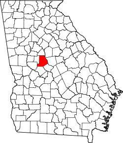
Website: www.monroecountygeorgia.com Das Monroe County[2] ist ein County im Bundesstaat Georgia der Vereinigten Staaten von Amerika. Der Verwaltungssitz (County Seat) ist Forsyth, benannt nach John Forsyth, einem US-amerikanischer Politiker, Außenminister und Gouverneur von Georgia. Im Jahr 2000 hatte das County 21.757 Einwohner und eine Bevölkerungsdichte von 21 Einwohnern pro Quadratkilometer.
Inhaltsverzeichnis
Geografie
Das County liegt im mittleren Nordwesten von Georgia und hat eine Fläche von 1030 Quadratkilometern, wovon 6 Quadratkilometer Wasseroberfläche sind und grenzt im Uhrzeigersinn an folgende Countys: Jasper County, Jones County, Bibb County, Crawford County, Upson County, Lamar County und Butts County.
Geschichte
Monroe County wurde am 15. Mai 1821 aus dem Land der Creek-Indianer gebildet. Benannt wurde es nach dem US-Präsidenten James Monroe.
Demografische Daten
Historische Einwohnerzahlen Census Einwohner ± in % 1830 16.202 — 1840 16.275 0,5 % 1850 16.985 4 % 1860 15.953 -6 % 1870 17.213 8 % 1880 18.808 9 % 1890 19.137 2 % 1900 20.682 8 % 1910 20.450 -1 % 1920 20.138 -2 % 1930 11.606 -40 % 1940 10.749 -7 % 1950 10.523 -2 % 1960 10.495 -0,3 % 1970 10.991 5 % 1980 14.610 30 % 1990 17.113 20 % 2000 21.757 30 % Vor 1900[3] 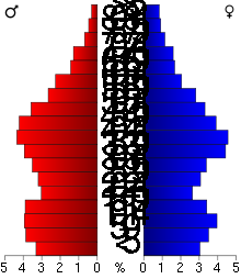 Alterspyramide für das Monroe County
Nach der Volkszählung im Jahr 2000 lebten im Monroe County 21.757 Menschen. Davon wohnten 626 Personen in Sammelunterkünften, die anderen Einwohner lebten in 7.719 Haushalten und 6.005 Familien. Die Bevölkerungsdichte betrug 21 Einwohner pro Quadratkilometer. Ethnisch betrachtet setzte sich die Bevölkerung zusammen aus 70,36 Prozent Weißen, 27,93 Prozent Afroamerikanern, 0,35 Prozent amerikanischen Ureinwohnern, 0,34 Prozent Asiaten, 0,03 Prozent Bewohnern aus dem pazifischen Inselraum und 0,25 Prozent aus anderen ethnischen Gruppen; 0,74 Prozent stammten von zwei oder mehr Ethnien ab. 1,29 Prozent der Gesamtbevölkerung waren spanischer oder lateinamerikanischer Abstammung.
Von den 7.719 Haushalten hatten 35,8 Prozent Kinder und Jugendliche unter 18 Jahren, die bei ihnen lebten. 59,6 Prozent waren verheiratete, zusammenlebende Paare, 13,8 Prozent waren allein erziehende Mütter und 22,2 Prozent waren keine Familien. 18,9 Prozent waren Singlehaushalte und in 7,4 Prozent lebten Menschen im Alter von 65 Jahren oder darüber. Die Durchschnittshaushaltsgröße betrug 2,74 und die durchschnittliche Familiengröße betrug 3,12 Personen.
26,3 Prozent der Bevölkerung waren unter 18 Jahre alt, 8,3 Prozent zwischen 18 und 24, 30,4 Prozent zwischen 25 und 44, 24,7 Prozent zwischen 45 und 64 und 10,3 Prozent waren 65 Jahre oder älter. Das Durchschnittsalter betrug 36 Jahre. Auf 100 weibliche Personen kamen statistisch 99,4 männliche Personen und auf 100 Frauen im Alter von 18 Jahren oder darüber kamen 97,2 Männer.
Das jährliche Durchschnittseinkommen eines Haushalts betrug 44.195 USD, das Durchschnittseinkommen der Familien 51.093 USD. Männer hatten ein Durchschnittseinkommen von 34.433 USD, Frauen 22.146 USD. Das Prokopfeinkommen betrug 19.580 USD. 7,3 Prozent der Familien und 9,8 Prozent der Bevölkerung lebten unterhalb der Armutsgrenze. [6]
Siehe auch
Einzelnachweise
- ↑ Auszug aus dem National Register of Historic Places. Abgerufen am 13. März 2011
- ↑ GNIS-ID: 343073. Abgerufen am 22. Februar 2011 (englisch).
- ↑ U.S. Census Bureau - Census of Population and Housing. Abgerufen am 15. März 2011
- ↑ Auszug aus Census.gov. Abgerufen am 28. Februar 2011
- ↑ Auszug aus factfinder.census.gov Abgerufen am 28. Februar 2011
- ↑ Monroe County, Georgia, Datenblatt mit den Ergebnissen der Volkszählung im Jahre 2000 bei factfinder.census.gov.
Weblinks
- georgia.gov, dort unter „Local Information | Counties“ (englisch)

Liste der Countys in Georgia
Appling | Atkinson | Bacon | Baker | Baldwin | Banks | Barrow | Bartow | Ben Hill | Berrien | Bibb | Bleckley | Brantley | Brooks | Bryan | Bulloch | Burke | Butts | Calhoun | Camden | Candler | Carroll | Catoosa | Charlton | Chatham | Chattahoochee | Chattooga | Cherokee | Clarke | Clay | Clayton | Clinch | Cobb | Coffee | Colquitt | Columbia | Cook | Coweta | Crawford | Crisp | Dade | Dawson | Decatur | DeKalb | Dodge | Dooly | Dougherty | Douglas | Early | Echols | Effingham | Elbert | Emanuel | Evans | Fannin | Fayette | Floyd | Forsyth | Franklin | Fulton | Gilmer | Glascock | Glynn | Gordon | Grady | Greene | Gwinnett | Habersham | Hall | Hancock | Haralson | Harris | Hart | Heard | Henry | Houston | Irwin | Jackson | Jasper | Jeff Davis | Jefferson | Jenkins | Johnson | Jones | Lamar | Lanier | Laurens | Lee | Liberty | Lincoln | Long | Lowndes | Lumpkin | Macon | Madison | Marion | McDuffie | McIntosh | Meriwether | Miller | Mitchell | Monroe | Montgomery | Morgan | Murray | Muscogee | Newton | Oconee | Oglethorpe | Paulding | Peach | Pickens | Pierce | Pike | Polk | Pulaski | Putnam | Quitman | Rabun | Randolph | Richmond | Rockdale | Schley | Screven | Seminole | Spalding | Stephens | Stewart | Sumter | Talbot | Taliaferro | Tattnall | Taylor | Telfair | Terrell | Thomas | Tift | Toombs | Towns | Treutlen | Troup | Turner | Twiggs | Union | Upson | Walker | Walton | Ware | Warren | Washington | Wayne | Webster | Wheeler | White | Whitfield | Wilcox | Wilkes | Wilkinson | Worth
Wikimedia Foundation.
Schlagen Sie auch in anderen Wörterbüchern nach:
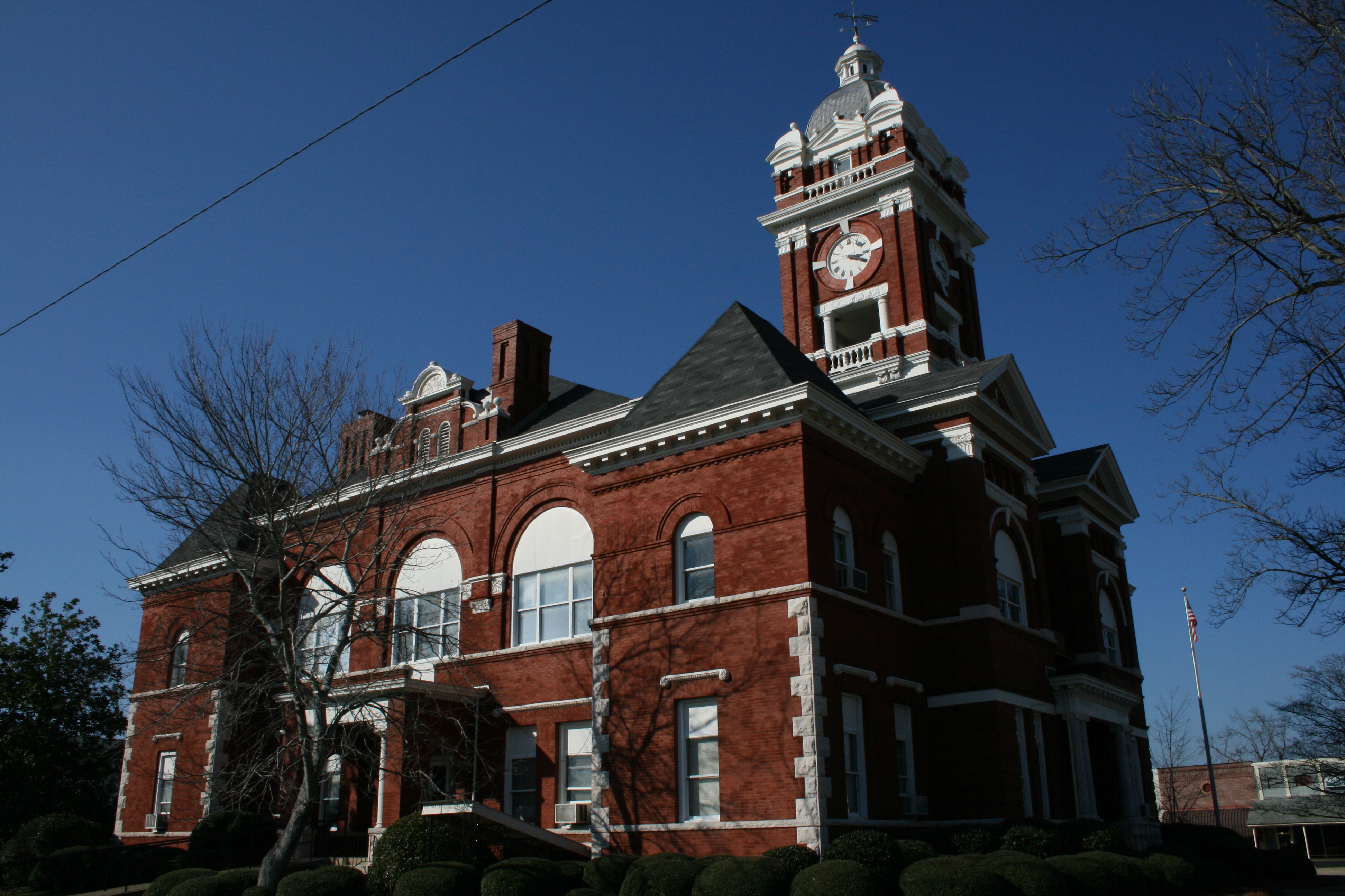
Monroe County, Georgia — Monroe County courthouse in Forsyth, Georgia … Wikipedia
National Register of Historic Places listings in Monroe County, Georgia — This is a list of properties and districts in Monroe County, Georgia that are listed on the National Register of Historic Places (NRHP). Map of all coordinates from Google Map of all coordinates from Bing … Wikipedia
Monroe County School District (Georgia) — Monroe County School District Address 25 Brooklyn Avenue Forsyth, Georgia, 31029 1910 … Wikipedia
Monroe County — is the name of seventeen counties in the United States, named after James Monroe, fifth President of the United States: Monroe County, Alabama Monroe County, Arkansas Monroe County, Florida Monroe County, Georgia Monroe County, Illinois Monroe… … Wikipedia
Monroe County — Es gibt in den Vereinigten Staaten 17 Countys mit dem Namen Monroe County: Monroe County (Alabama) Monroe County (Arkansas) Monroe County (Florida) Monroe County (Georgia) Monroe County (Illinois) Monroe County (Indiana) Monroe County (Iowa)… … Deutsch Wikipedia
Monroe County Courthouse — may refer to: in the United States (by state) Old Monroe County Courthouse in Monroeville, Alabama, listed on the NRHP in Alabama Monroe County Courthouse (Clarendon, Arkansas), Clarendon, AR, listed on the NRHP in Arkansas Monroe County… … Wikipedia
Monroe County Courthouse (Indiana) — Monroe County Courthouse U.S. National Register of Historic Places … Wikipedia
Monroe County Courthouse (Ohio) — Monroe County Courthouse U.S. National Register of Historic Places … Wikipedia
Monroe County Courthouse — bezeichnet mehrere gleichnamige, im NRHP gelistete, Objekte: Monroe County Courthouse (Arkansas), ID Nr. 76000439 Monroe County Courthouse (Georgia), ID Nr. 80001121 Monroe County Courthouse (Indiana), ID Nr. 76000012 Monroe County Courthouse… … Deutsch Wikipedia
Monroe County Courthouse (Iowa) — Monroe County Courthouse U.S. National Register of Historic Places … Wikipedia
Monroe County (Georgia)


18+
© Academic, 2000-2024
- Kontaktieren Sie uns: Unterstützung, Werbung
Wörterbücher Export, schritte mit PHP, Joomla, Drupal, WordPress, MODx.