- Jones County (Georgia)
-
Verwaltung US-Bundesstaat: Georgia Verwaltungssitz: Gray Adresse des
Verwaltungssitzes:Jones County Administration
P.O. Box 1359
Gray, Georgia, 31032-1359Gründung: 10. Dezember 1807 Gebildet aus: Baldwin County Vorwahl: 001 478 Demographie Einwohner: 23.639 (2000) Bevölkerungsdichte: 23,2 Einwohner/km² Geographie Fläche gesamt: 1.024 km² Wasserfläche: 4 km² Karte 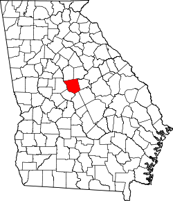
Website: www.jonescounty.org Das Jones County[1] ist ein County im Bundesstaat Georgia der Vereinigten Staaten von Amerika. Der Verwaltungssitz (County Seat) ist Gray, benannt nach James Madison Gray, der die Konföderierten während des Bürgerkrieges finanziell unterstützte. Bei der Volkszählung im Jahr 2000 hatte das County 23.639 Einwohner und eine Bevölkerungsdichte von 23 Einwohner pro Quadratkilometer.
Inhaltsverzeichnis
Geografie
Das County liegt etwa 30 km nördlich des geographischen Zentrums von Georgia und hat eine Fläche von 1024 Quadratkilometern, wovon 4 Quadratkilometer Wasserfläche sind und grenzt im Uhrzeigersinn an folgende Countys: Putnam County, Baldwin County, Wilkinson County, Twiggs County, Bibb County, Monroe County, und Jasper County.
Geschichte
Jones County wurde am 10. Dezember 1807 als 30. County von Georgia aus Teilen des Baldwin County gebildet. Benannt wurde es nach James Jones, einem Kongress-Mitglied von Georgia.
Demografische Daten
Historische Einwohnerzahlen Census Einwohner ± in % 1810 8597 — 1820 16.570 90 % 1830 13.345 -20 % 1840 10.065 -20 % 1850 10.224 2 % 1860 9107 -10 % 1870 9436 4 % 1880 11.613 20 % 1890 12.709 9 % 1900 13.358 5 % 1910 13.103 -2 % 1920 13.269 1 % 1930 8992 -30 % 1940 8331 -7 % 1950 7538 -10 % 1960 8468 10 % 1970 12.218 40 % 1980 16.579 40 % 1990 20.739 30 % 2000 23.639 10 % Vor 1900[2] Nach der Volkszählung im Jahr 2000 lebten im Jones County 23.639 Menschen in 8.659 Haushalten und 6.667 Familien. Die Bevölkerungsdichte betrug 23 Einwohner pro Quadratkilometer. Ethnisch betrachtet setzte sich die Bevölkerung zusammen aus 75,02 Prozent Weißen, 23,29 Prozent Afroamerikanern, 0,17 Prozent amerikanischen Ureinwohnern, 0,53 Prozent Asiaten, 0,03 Prozent Bewohnern aus dem pazifischen Inselraum und 0,25 Prozent aus anderen ethnischen Gruppen; 0,71 Prozent stammten von zwei oder mehr Ethnien ab. 0,71 Prozent der Gesamtbevölkerung waren spanischer oder lateinamerikanischer Abstammung.
 Alterspyramide für das Jones County
Von den 8.659 Haushalten hatten 37,5 Prozent Kinder und Jugendliche unter 18 Jahren, die bei ihnen lebten. 58,7 Prozent waren verheiratete, zusammenlebende Paare, 13,3 Prozent waren allein erziehende Mütter und 23,0 Prozent waren keine Familien. 20,2 Prozent waren Singlehaushalte und in 7,1 Prozent lebten Menschen im Alter von 65 Jahren oder darüber. Die Durchschnittshaushaltsgröße betrug 2,69 und die durchschnittliche Familiengröße betrug 3,09 Personen.
27,1 Prozent der Bevölkerung waren unter 18 Jahre alt, 7,9 Prozent zwischen 18 und 24, 30,6 Prozent zwischen 25 und 44, 24,1 Prozent zwischen 45 und 64 und 10,3 Prozent waren 65 Jahre oder älter. Das Durchschnittsalter betrug 36 Jahre. Auf 100 weibliche Personen kamen statistisch 95,4 männliche Personen und auf 100 Frauen im Alter von 18 Jahren oder darüber kamen 91,3 Männer.
Das jährliche Durchschnittseinkommen eines Haushalts betrug 43.301 USD, das Durchschnittseinkommen der Familien 48.966 USD. Männer hatten ein Durchschnittseinkommen von 36.464 USD, Frauen 26.736 USD. Das Prokopfeinkommen betrug 19.126 USD. 7,7 Prozent der Familien und 10,2 Prozent der Bevölkerung lebten unterhalb der Armutsgrenze. [5]
Siehe auch
Einzelnachweise
- ↑ GNIS-ID: 345367. Abgerufen am 22. Februar 2011 (englisch).
- ↑ U.S. Census Bureau - Census of Population and Housing. Abgerufen am 15. März 2011
- ↑ Auszug aus Census.gov. Abgerufen am 28. Februar 2011
- ↑ Auszug aus factfinder.census.gov Abgerufen am 28. Februar 2011
- ↑ Jones County, Georgia, Datenblatt mit den Ergebnissen der Volkszählung im Jahre 2000 bei factfinder.census.gov.
Weblinks
- georgia.gov, dort unter „Local Information | Counties“ (englisch)

Liste der Countys in Georgia
Appling | Atkinson | Bacon | Baker | Baldwin | Banks | Barrow | Bartow | Ben Hill | Berrien | Bibb | Bleckley | Brantley | Brooks | Bryan | Bulloch | Burke | Butts | Calhoun | Camden | Candler | Carroll | Catoosa | Charlton | Chatham | Chattahoochee | Chattooga | Cherokee | Clarke | Clay | Clayton | Clinch | Cobb | Coffee | Colquitt | Columbia | Cook | Coweta | Crawford | Crisp | Dade | Dawson | Decatur | DeKalb | Dodge | Dooly | Dougherty | Douglas | Early | Echols | Effingham | Elbert | Emanuel | Evans | Fannin | Fayette | Floyd | Forsyth | Franklin | Fulton | Gilmer | Glascock | Glynn | Gordon | Grady | Greene | Gwinnett | Habersham | Hall | Hancock | Haralson | Harris | Hart | Heard | Henry | Houston | Irwin | Jackson | Jasper | Jeff Davis | Jefferson | Jenkins | Johnson | Jones | Lamar | Lanier | Laurens | Lee | Liberty | Lincoln | Long | Lowndes | Lumpkin | Macon | Madison | Marion | McDuffie | McIntosh | Meriwether | Miller | Mitchell | Monroe | Montgomery | Morgan | Murray | Muscogee | Newton | Oconee | Oglethorpe | Paulding | Peach | Pickens | Pierce | Pike | Polk | Pulaski | Putnam | Quitman | Rabun | Randolph | Richmond | Rockdale | Schley | Screven | Seminole | Spalding | Stephens | Stewart | Sumter | Talbot | Taliaferro | Tattnall | Taylor | Telfair | Terrell | Thomas | Tift | Toombs | Towns | Treutlen | Troup | Turner | Twiggs | Union | Upson | Walker | Walton | Ware | Warren | Washington | Wayne | Webster | Wheeler | White | Whitfield | Wilcox | Wilkes | Wilkinson | Worth
Wikimedia Foundation.
Schlagen Sie auch in anderen Wörterbüchern nach:
Jones County, Georgia — Infobox U.S. County county = Jones County state = Georgia seallink = founded = December 10, 1807 seat wl = Gray largest city wl = Gray area total sq mi = 395 area total km2 = 1024 area land sq mi = 394 area land km2 = 1020 area water sq mi = 2… … Wikipedia
National Register of Historic Places listings in Jones County, Georgia — This is a list of properties and districts in Jones County, Georgia that are listed on the National Register of Historic Places (NRHP). Map of all coordinates from Google Map of all coordinates from Bing … Wikipedia
Jones County — is the name of six counties in the United States: Jones County, Georgia Jones County, Iowa Jones County, Mississippi Jones County, North Carolina Jones County, South Dakota Jones County, Texas This disambiguation page lists artic … Wikipedia
Jones County — ist der Name folgender Countys in den Vereinigten Staaten: Jones County (Georgia) Jones County (Iowa) Jones County (Mississippi) Jones County (North Carolina) Jones County (South Dakota) Jones County (Texas) … Deutsch Wikipedia
Jones County Courthouse — bezeichnet mehrere gleichnamige, im NRHP gelistete, Objekte: Jones County Courthouse (Georgia), ID Nr. 80001102 Jones County Courthouse (Texas), ID Nr. 03000330 Diese Seite ist eine Begriffsklärung zur Unterscheidung mehrerer mi … Deutsch Wikipedia
Bibb County, Georgia — Infobox U.S. County county = Bibb County state = Georgia seallink = map size = 225 founded = 1822 seat = Macon largest city = Macon area total sq mi = 255 area total km2 = 661 area land sq mi = 250 area land km2 = 647 area water sq mi = 5 area… … Wikipedia
Baldwin County, Georgia — Infobox U.S. County county = Baldwin County state = Georgia seallink = map size = 225 founded = 1803 seat = Milledgeville largest city = Milledgeville area total sq mi = 268 area total km2 = 693 area land sq mi = 258 area land km2 = 669 area… … Wikipedia
Jasper County, Georgia — Infobox U.S. County county = Jasper County state = Georgia seallink = map size = 225 founded = December 10, 1807 seat = Monticello largest city = Monticello area total sq mi = 374 area total km2 = 968 area land sq mi = 370 area land km2 = 959… … Wikipedia
Twiggs County, Georgia — Infobox U.S. County county = Twiggs County state = Georgia founded year = 1809 founded date = December 14 seat wl = Jeffersonville largest city wl = Jeffersonville area total sq mi = 363 area total km2 = 940 area land sq mi = 360 area land km2 =… … Wikipedia
Henry County (Georgia) — County Courthouse in McDonough, gelistet im NRHP Nr. 80001092[1] Verwaltung US Bundesstaat … Deutsch Wikipedia
Jones County (Georgia)


18+
© Academic, 2000-2024
- Kontaktieren Sie uns: Unterstützung, Werbung
Wörterbücher Export, schritte mit PHP, Joomla, Drupal, WordPress, MODx.