- Pope County (Minnesota)
-
Verwaltung US-Bundesstaat: Minnesota Verwaltungssitz: Glenwood Adresse des
Verwaltungssitzes:County Courthouse
130 E. Minnesota Ave.
Glenwood, MN 56334-9253Gründung: 20. Februar 1862 Gebildet aus: Cass County
Pierce CountyVorwahl: 001 320 Demographie Einwohner: 10.995 (2010) Bevölkerungsdichte: 6,3 Einwohner/km² Geographie Fläche gesamt: 1.858 km² Wasserfläche: 122 km² Karte 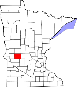
Website: www.co.pope.mn.us Das Pope County[1] ist ein County im US-amerikanischen Bundesstaat Minnesota. Bei der Volkszählung im Jahr 2010 hatte das County 10.995 Einwohner und eine Bevölkerungsdichte von 6,3 Einwohnern pro Quadratkilometer. Der Verwaltungssitz (County Seat) ist Glenwood.
Inhaltsverzeichnis
Geografie
Das County liegt im mittleren Westen von Minnesota und hat eine Fläche von 1.858 Quadratkilometern, wovon 122 Quadratkilometer Wasserfläche sind. Es grenzt an folgende Countys:
Grant County Douglas County Stevens County 
Stearns County Swift County Kandiyohi County Geschichte
 J. Pope
Das Pope County wurde am 20. Februar 1862 aus Teilen des Cass County und dem nur noch in Wisconsin existierenden Pierce County gebildet. Benannt wurde es nach John Pope (1822-1892), einem General der Unionstruppen im Amerikanischen Bürgerkrieg.
Demografische Daten
Historische Einwohnerzahlen Census Einwohner ± in % 1870 2691 — 1880 5874 100 % 1890 10.032 70 % 1900 12.577 30 % 1910 12.746 1 % 1920 13.631 7 % 1930 13.085 -4 % 1940 13.544 4 % 1950 12.862 -5 % 1960 11.914 -7 % 1970 11.107 -7 % 1980 11.657 5 % 1990 10.745 -8 % 2000 11.236 5 % 2010 10.995 -2 % Vor 1900[2] 1900–1990[3] 2000[4] 2010[5] Nach der Volkszählung im Jahr 2000 lebten im Pope County 11.236 Menschen in 4.513 Haushalten und 3.064 Familien. Die Bevölkerungsdichte betrug 6 Einwohner pro Quadratkilometer. Ethnisch betrachtet setzte sich die Bevölkerung zusammen aus 98,85 Prozent Weißen, 0,20 Prozent Afroamerikanern, 0,18 Prozent amerikanischen Ureinwohnern, 0,08 Prozent Asiaten, 0,01 Prozent Bewohnern aus dem pazifischen Inselraum und 0,18 Prozent aus anderen ethnischen Gruppen; 0,50 Prozent stammten von zwei oder mehr Ethnien ab. 0,51 Prozent der Bevölkerung waren spanischer oder lateinamerikanischer Abstammung.
Von den 4.513 Haushalten hatten 29,7 Prozent Kinder unter 18 Jahren, die bei ihnen lebten. 59,0 Prozent davon waren verheiratete, zusammenlebende Paare. 5,9 Prozent waren alleinerziehende Mütter und 32,1 Prozent waren keine Familien. 28,7 Prozent waren Singlehaushalte und in 16,1 Prozent der Haushalte lebten alleinstehende Menschen im Alter von 65 Jahren oder darüber. Die Durchschnittshaushaltsgröße lag bei 2,42 Personen, die durchschnittliche Familiengröße bei 2,99 Personen, die verschiedenen der genannten Gruppen angehörten.
24,8 Prozent der Bevölkerung waren unter 18 Jahre alt. 6,7 Prozent waren zwischen 18 und 24, 23,1 Prozent zwischen 25 und 44, 23,8 Prozent zwischen 45 und 64 und 21,5 Prozent waren älter als 65 Jahre. Das Durchschnittsalter betrug 42 Jahre. Auf 100 weibliche kamen statistisch 96,9 männliche Personen. Auf 100 Frauen im Alter von 18 Jahren oder darüber kamen 92,9 Männer.
Das jährliche Durchschnittseinkommen eines Haushalts betrug 35.633 USD und das Durchschnittseinkommen einer Familie betrug 42.818 USD. Männer hatten ein Durchschnittseinkommen von 30.452 USD, Frauen 20.511 USD. Das Pro - Kopf - Einkommen betrug 19.032 USD. 5,8 Prozent der Familien und 8,8 Prozent der Einwohner lebten unterhalb der Armutsgrenze.[6]
Städte und Gemeinden
- Brooten1
- Cyrus
- Farwell
- Glenwood
- Long Beach
- Lowry
- Sedan
- Starbuck
- Villard
- Westport
1 - teilweise im Stearns County
Einzelnachweise
- ↑ GNIS-ID: 659506. Abgerufen am 22. Februar 2011 (englisch).
- ↑ U.S. Census Bureau - Census of Population and Housing Abgerufen am 15. März 2011
- ↑ Auszug aus Census.gov Abgerufen am 18. Februar 2011
- ↑ Auszug aus factfinder.census.gov Abgerufen am 18. Februar 2011
- ↑ United States Census 2010 Abgerufen am 14. August 2011
- ↑ Pope County, Minnesota Datenblatt mit den Ergebnissen der Volkszählung im Jahre 2000 bei factfinder.census.gov
Weblinks
-
 Commons: Pope County, Minnesota – Sammlung von Bildern, Videos und Audiodateien
 - Offizielle Webseite
- Yahoo Bildersuche - Pope County
- U.S. Census Buero, State & County QuickFacts - Pope County
- www.city-data.com - Pope County

Liste der Countys in Minnesota
Aitkin | Anoka | Becker | Beltrami | Benton | Big Stone | Blue Earth | Brown | Carlton | Carver | Cass | Chippewa | Chisago | Clay | Clearwater | Cook | Cottonwood | Crow Wing | Dakota | Dodge | Douglas | Faribault | Fillmore | Freeborn | Goodhue | Grant | Hennepin | Houston | Hubbard | Isanti | Itasca | Jackson | Kanabec | Kandiyohi | Kittson | Koochiching | Lac qui Parle | Lake | Lake of the Woods | Le Sueur | Lincoln | Lyon | Mahnomen | Marshall | Martin | McLeod | Meeker | Mille Lacs | Morrison | Mower | Murray | Nicollet | Nobles | Norman | Olmsted | Otter Tail | Pennington | Pine | Pipestone | Polk | Pope | Ramsey | Red Lake | Redwood | Renville | Rice | Rock | Roseau | Scott | Sherburne | Sibley | St. Louis | Stearns | Steele | Stevens | Swift | Todd | Traverse | Wabasha | Wadena | Waseca | Washington | Watonwan | Wilkin | Winona | Wright | Yellow Medicine
Wikimedia Foundation.
Schlagen Sie auch in anderen Wörterbüchern nach:
Pope County, Minnesota — Infobox U.S. County county = Pope County state = Minnesota founded year = 1862 [http://www.house.leg.state.mn.us/hinfo/govseries/No33.htm] founded date = February 20 seat wl = Glenwood largest city wl = Glenwood area total sq mi = 717 area total… … Wikipedia
National Register of Historic Places listings in Pope County, Minnesota — Location of Pope County in Minnesota This is a list of the National Register of Historic Places listings in Pope County, Minnesota. It is intended to be a complete list of the properties and districts on the National Register of Historic Places… … Wikipedia
Chippewa Falls Township, Pope County, Minnesota — Chippewa Falls Township, Minnesota Township … Wikipedia
Minnewaska Township, Pope County, Minnesota — Minnewaska is also the name of a state park and lake in New York State. Minnewaska Township, Minnesota Township … Wikipedia
New Prairie Township, Pope County, Minnesota — New Prairie Township, Minnesota Township … Wikipedia
Nora Township, Pope County, Minnesota — For the city in Sweden, see Nora, Sweden. Nora Township, Minnesota Township … Wikipedia
Bangor Township, Pope County, Minnesota — This article is about the Bangor Township in Minnesota, USA. For other places named Bangor, see Bangor. Infobox Settlement official name = Bangor Township, Minnesota settlement type = Township nickname = motto = imagesize = image caption = image… … Wikipedia
Barsness Township, Pope County, Minnesota — Infobox Settlement official name = Barsness Township, Minnesota settlement type = Township nickname = motto = imagesize = image caption = image |pushpin pushpin label position =left pushpin map caption =Location within the state of Minnesota… … Wikipedia
Ben Wade Township, Pope County, Minnesota — Infobox Settlement official name = Ben Wade Township, Minnesota settlement type = Township nickname = motto = imagesize = image caption = image |pushpin pushpin label position =left pushpin map caption =Location within the state of Minnesota… … Wikipedia
Blue Mounds Township, Pope County, Minnesota — Infobox Settlement official name = Blue Mounds Township, Minnesota settlement type = Township nickname = motto = imagesize = image caption = image |pushpin pushpin label position =left pushpin map caption =Location within the state of Minnesota… … Wikipedia
Pope County (Minnesota)


18+
© Academic, 2000-2024
- Kontaktieren Sie uns: Unterstützung, Werbung
Wörterbücher Export, schritte mit PHP, Joomla, Drupal, WordPress, MODx.