- Dakota County (Minnesota)
-
Verwaltung US-Bundesstaat: Minnesota Verwaltungssitz: Hastings Adresse des
Verwaltungssitzes:County Courthouse
1590 West Highway 55
Hastings, MN 55033-2372Gründung: 27. Oktober 1849 Gebildet aus: "freiem" Territorium Vorwahl: 001 651 Demographie Einwohner: 398.552 (2010) Bevölkerungsdichte: 270 Einwohner/km² Geographie Fläche gesamt: 1.519 km² Wasserfläche: 43 km² Karte 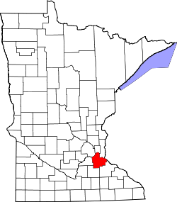
Website: www.co.dakota.mn.us Das Dakota County[2] ist ein County im US-amerikanischen Bundesstaat Minnesota. Bei der Volkszählung im Jahr 2010 hatte das County 398.552 Einwohner und eine Bevölkerungsdichte von 270 Einwohnern pro Quadratkilometer. Der Verwaltungssitz (County Seat) ist Hastings, das nach dem Gouverneur Henry Hastings Sibley benannt wurde.
Das Dakota County bidet den südöstlichen Teil der Metropolregion Minneapolis - Saint Paul.
Inhaltsverzeichnis
Geografie
Das County liegt im Südosten von Minnesota, grenzt im Nordosten an Wisconsin wobei die Grenze durch den Mississippi gebildet wird. Die Nordgrenze des Countys wird vom Minnesota River gebildet. Das Dakota County hat eine Fläche von 1.519 Quadratkilometern, wovon 43 Quadratkilometer Wasserfläche sind. Es grenzt an folgende Countys:
Hennepin County Ramsey County Washington County Scott County 
Pierce County
(Wisconsin)Rice County Goodhue County Geschichte
 Taoyateduta (Little Crow), Häuptling der Dakota
Das Dakota County wurde am 27. Oktober 1849 aus als frei bezeichneten - in Wirklichkeit aber von Indianern besiedelten - Territorium gebildet. Benannt wurde das County nach den ursprünglich hier siedelnden Dakota.
Demografische Daten
Historische Einwohnerzahlen Census Einwohner ± in % 1850 584 — 1860 9093 1.000 % 1870 16.312 80 % 1880 17.391 7 % 1890 20.240 20 % 1900 21.733 7 % 1910 25.171 20 % 1920 28.967 20 % 1930 34.592 20 % 1940 39.660 10 % 1950 49.019 20 % 1960 78.303 60 % 1970 139.808 80 % 1980 194.279 40 % 1990 275.227 40 % 2000 355.904 30 % 2010 398.552 10 % Vor 1900[3] 1900–1990[4] 2000[5] 2010[6] Nach der Volkszählung im Jahr 2000 lebten im Dakota County 355.904 Menschen in 131.151 Haushalten und 94.035 Familien. Die Bevölkerungsdichte betrug 241 Einwohner pro Quadratkilometer. Ethnisch betrachtet setzte sich die Bevölkerung zusammen aus 91,36 Prozent Weißen, 2,27 Prozent Afroamerikanern, 0,38 Prozent amerikanischen Ureinwohnern, 2,89 Prozent Asiaten, 0,05 Prozent Bewohnern aus dem pazifischen Inselraum und 1,29 Prozent aus anderen ethnischen Gruppen; 1,75 Prozent stammten von zwei oder mehr Ethnien ab. 2,94 Prozent der Bevölkerung waren spanischer oder lateinamerikanischer Abstammung, die verschiedenen der genannten Gruppen angehörten.
Von den 131.151 Haushalten hatten 40,0 Prozent Kinder unter 18 Jahren, die bei ihnen lebten. 59,2 Prozent davon waren verheiratete, zusammenlebende Paare. 9,1 Prozent waren alleinerziehende Mütter und 28,3 Prozent waren keine Familien. 21,7 Prozent waren Singlehaushalte und in 5,5 Prozent der Haushalte lebten alleinstehende Menschen im Alter von 65 Jahren oder darüber. Die Durchschnittshaushaltsgröße lag bei 2,70 Personen, die durchschnittliche Familiengröße bei 3,19 Personen.
29,2 Prozent der Bevölkerung waren unter 18 Jahre alt. 7,9 Prozent waren zwischen 18 und 24, 34,3 Prozent zwischen 25 und 44, 21,2 Prozent zwischen 45 und 64 und 7,4 Prozent waren älter als 65 Jahre. Das Durchschnittsalter betrug 34 Jahre. Auf 100 weibliche kamen statistisch 97,6 männliche Personen. Auf 100 Frauen im Alter von 18 Jahren oder darüber kamen 94,7 Männer.
Das jährliche Durchschnittseinkommen eines Haushalts betrug 61.863 USD und das Durchschnittseinkommen einer Familie betrug 71.062 USD. Männer hatten ein Durchschnittseinkommen von 46.827 USD, Frauen 32.189 USD. Das Pro - Kopf - Einkommen betrug 27.008 USD. 2,4 Prozent der Familien und 3,6 Prozent der Einwohner lebten unterhalb der Armutsgrenze.[7]
Städte und Gemeinden
- Apple Valley
- Burnsville
- Coates
- Eagan
- Farmington
- Hampton
- Hastings1
- Inver Grove Heights
- Lakeville
- Lilydale
- Mendota
- Mendota Heights
- Miesville
- New Trier
- Northfield2
- Randolph
- Rosemount
- South St. Paul
- Sunfish Lake
- Vermillion
- West St. Paul
1 - teilweise im Washington County
2 - teilweise im Rice CountyEinzelnachweise
- ↑ Auszug aus dem National Register of Historic Places Abgerufen am 13. März 2011
- ↑ GNIS-ID: 659464. Abgerufen am 22. Februar 2011 (englisch).
- ↑ U.S. Census Bureau _ Census of Population and Housing Abgerufen am 17. Februar 2011
- ↑ Auszug aus Census.gov. Abgerufen am 17. Februar 2011
- ↑ Auszug aus factfinder.census.gov Abgerufen am 18. Februar 2011
- ↑ United States Census 2010 Abgerufen am 19. Juli 2011
- ↑ Dakota County, Minnesota Datenblatt mit den Ergebnissen der Volkszählung im Jahre 2000 bei factfinder.census.gov
Weblinks
-
 Commons: Dakota County, Minnesota – Sammlung von Bildern, Videos und Audiodateien
 - Offizielle Webseite
- www.city-data.com

Liste der Countys in Minnesota
Aitkin | Anoka | Becker | Beltrami | Benton | Big Stone | Blue Earth | Brown | Carlton | Carver | Cass | Chippewa | Chisago | Clay | Clearwater | Cook | Cottonwood | Crow Wing | Dakota | Dodge | Douglas | Faribault | Fillmore | Freeborn | Goodhue | Grant | Hennepin | Houston | Hubbard | Isanti | Itasca | Jackson | Kanabec | Kandiyohi | Kittson | Koochiching | Lac qui Parle | Lake | Lake of the Woods | Le Sueur | Lincoln | Lyon | Mahnomen | Marshall | Martin | McLeod | Meeker | Mille Lacs | Morrison | Mower | Murray | Nicollet | Nobles | Norman | Olmsted | Otter Tail | Pennington | Pine | Pipestone | Polk | Pope | Ramsey | Red Lake | Redwood | Renville | Rice | Rock | Roseau | Scott | Sherburne | Sibley | St. Louis | Stearns | Steele | Stevens | Swift | Todd | Traverse | Wabasha | Wadena | Waseca | Washington | Watonwan | Wilkin | Winona | Wright | Yellow Medicine
Wikimedia Foundation.
Schlagen Sie auch in anderen Wörterbüchern nach:
Dakota County, Minnesota — Location in the state of Minnesota … Wikipedia
County Road 42 (Dakota County, Minnesota) — County State Aid Highway 42, usually called County Road 42, is a primary arterial highway in Dakota and Scott Counties of southeastern Minnesota. These two counties form the southernmost portion of the Twin Cities Metropolitan Area, although CSAH … Wikipedia
National Register of Historic Places listings in Dakota County, Minnesota — Dakota County This is a list of properties on the National Register of Historic Places in Dakota County, Minnesota. Dakota County is a county located in the southeastern part of the U.S. state of Minnesota, bounded on the northeast side by the… … Wikipedia
List of Registered Historic Places in Dakota County, Minnesota — This is a List of Registered Historic Places in Dakota County, Minnesota.Dakota County is a county located in the southeastern part of the U.S. state of Minnesota, bounded on the northeast side by the Upper Mississippi River, and on the northwest … Wikipedia
Douglas Township, Dakota County, Minnesota — Douglas Township, Minnesota Township … Wikipedia
Marshan Township, Dakota County, Minnesota — Marshan Township, Minnesota Township … Wikipedia
Nininger Township, Dakota County, Minnesota — This article is about the township. For the ghost town of the same name, see Nininger, Minnesota Nininger Township, Minnesota Township … Wikipedia
Eureka Township, Dakota County, Minnesota — Infobox Settlement official name = Eureka Township, Minnesota settlement type = Township nickname = motto = imagesize = image caption = image |pushpin pushpin label position =left pushpin map caption =Location within the state of Minnesota… … Wikipedia
Castle Rock Township, Dakota County, Minnesota — Infobox Settlement official name = Castle Rock Township, Minnesota settlement type = Township nickname = motto = imagesize = image caption = image |pushpin pushpin label position =left pushpin map caption =Location within the state of Minnesota… … Wikipedia
Empire Township, Dakota County, Minnesota — Infobox Settlement official name = Empire Township, Minnesota settlement type = Township nickname = motto = imagesize = image caption = image |pushpin pushpin label position =left pushpin map caption =Location within the state of Minnesota… … Wikipedia
Dakota County (Minnesota)


18+
© Academic, 2000-2024
- Kontaktieren Sie uns: Unterstützung, Werbung
Wörterbücher Export, schritte mit PHP, Joomla, Drupal, WordPress, MODx.