- Ramsey County (Minnesota)
-
Verwaltung US-Bundesstaat: Minnesota Verwaltungssitz: Saint Paul Adresse des
Verwaltungssitzes:County Courthouse
15 W Kellogg Blvd.
Saint Paul, MN 55102-1614Gründung: 27. Oktober 1849 Gebildet aus: St. Croix County Vorwahl: 001 651 Demographie Einwohner: 508.640 (2010) Bevölkerungsdichte: 1.259 Einwohner/km² Geographie Fläche gesamt: 441 km² Wasserfläche: 37 km² Karte 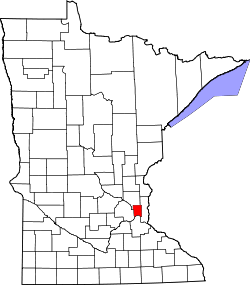
Website: www.co.ramsey.mn.us Ramsey County[2] ist ein County im US-amerikanischen Bundesstaat Minnesota. Bei der Volkszählung im Jahr 2010 hatte das County 508.640 Einwohner und eine Bevölkerungsdichte von 1.259 Einwohnern pro Quadratkilometer. Der Verwaltungssitz (County Seat) ist Saint Paul.
Das Ramsey County liegt im Zentrum der Metropolregion Minneapolis - Saint Paul.
Inhaltsverzeichnis
Geografie
Das County liegt im Südosten von Minnesota, ist im Osten etwa 35 km von Wisconsin entfernt und hat eine Fläche von 441 Quadratkilometern, wovon 37 Quadratkilometer Wasserfläche sind. Es grenzt an folgende Countys:
Anoka County Hennepin County 
Washington County Dakota County Geschichte
 Ramsey
Das Ramsey County wurde am 27. Oktober 1849 aus Teilen des nur noch in Wisconsin existierenden St. Croix County gebildet. Benannt wurde es nach Alexander Ramsey (1815-1903), dem zweiten Gouverneur von Minnesota (1860-1863) und US-Kriegsminister (1879-1881).
Demografische Daten
Historische Einwohnerzahlen Census Einwohner ± in % 1850 2227 — 1860 12.150 400 % 1870 23.085 90 % 1880 45.890 100 % 1890 139.796 200 % 1900 170.554 20 % 1910 223.675 30 % 1920 244.554 9 % 1930 286.721 20 % 1940 309.935 8 % 1950 355.332 10 % 1960 422.525 20 % 1970 476.255 10 % 1980 459.784 -3 % 1990 485.765 6 % 2000 511.035 5 % 2010 508.640 -0,5 % Vor 1900[3] 1900–1990[4] 2000[5] 2010[6] Nach der Volkszählung im Jahr 2000 lebten im Ramsey County 511.035 Menschen in 201.236 Haushalten und 119.936 Familien. Die Bevölkerungsdichte betrug 1.267 Einwohner pro Quadratkilometer. Ethnisch betrachtet setzte sich die Bevölkerung zusammen aus 77,37 Prozent Weißen, 7,61 Prozent Afroamerikanern, 0,83 Prozent amerikanischen Ureinwohnern, 8,77 Prozent Asiaten, 0,06 Prozent Bewohnern aus dem pazifischen Inselraum und 2,45 Prozent aus anderen ethnischen Gruppen; 2,90 Prozent stammten von zwei oder mehr Ethnien ab. 5,28 Prozent der Bevölkerung waren spanischer oder lateinamerikanischer Abstammung, die verschiedenen der genannten Gruppen angehörten.
Von den 201.236 Haushalten hatten 29,8 Prozent Kinder unter 18 Jahren, die bei ihnen lebten. 44,0 Prozent davon waren verheiratete, zusammenlebende Paare. 11,9 Prozent waren alleinerziehende Mütter und 40,4 Prozent waren keine Familien. 32,0 Prozent waren Singlehaushalte und in 9,5 Prozent der Haushalte lebten alleinstehende Menschen im Alter von 65 Jahren oder darüber. Die Durchschnittshaushaltsgröße lag bei 2,45 Personen, die durchschnittliche Familiengröße bei 3,16 Personen.
25,6 Prozent der Bevölkerung waren unter 18 Jahre alt. 11,3 Prozent waren zwischen 18 und 24, 30,7 Prozent zwischen 25 und 44, 20,7 Prozent zwischen 45 und 64 und 11,6 Prozent waren älter als 65 Jahre. Das Durchschnittsalter betrug 34 Jahre. Auf 100 weibliche kamen statistisch 93 männliche Personen. Auf 100 Frauen im Alter von 18 Jahren oder darüber kamen 89,2 Männer.
Das jährliche Durchschnittseinkommen eines Haushalts betrug 45.722 USD und das Durchschnittseinkommen einer Familie betrug 57.747 USD. Männer hatten ein Durchschnittseinkommen von 39.806 USD, Frauen 30.814 USD. Das Pro - Kopf - Einkommen betrug 23.536 USD. 7,4 Prozent der Familien und 10,6 Prozent der Einwohner lebten unterhalb der Armutsgrenze.[7]
Städte und Gemeinden
- Arden Hills
- Blaine1
- Falcon Heights
- Gem Lake
- Lauderdale
- Little Canada
- Maplewood
- Mounds View
- New Brighton
- North Oaks
- North St. Paul
- Roseville
- Shoreview
- St. Anthony2
- Saint Paul
- Spring Lake Park1
- Vadnais Heights
- White Bear Lake3
1 - teilweise im Anoka County
2 - teilweise im Hennepin County
3 - teilweise im Washington CountyEinzelnachweise
- ↑ Auszug aus dem National Register of Historic Places - Nr. 83000940 Abgerufen am 14. August 2011
- ↑ GNIS-ID: 659507. Abgerufen am 22. Februar 2011 (englisch).
- ↑ U.S. Census Bureau _ Census of Population and Housing Abgerufen am 17. Februar 2011
- ↑ Auszug aus Census.gov Abgerufen am 17. Februar 2011
- ↑ Auszug aus factfinder.census.gov Abgerufen am 18. Februar 2011
- ↑ United States Census 2010 Abgerufen am 14. August 2011
- ↑ Ramsey County, Minnesota Datenblatt mit den Ergebnissen der Volkszählung im Jahre 2000 bei factfinder.census.gov
Weblinks
-
 Commons: Ramsey County, Minnesota – Sammlung von Bildern, Videos und Audiodateien
 - Offizielle Webseite
- Yahoo Bildersuche - Ramsey County
- U.S. Census Buero, State & County QuickFacts - Ramsey County
- www.city-data.com - Ramsey County

Liste der Countys in Minnesota
Aitkin | Anoka | Becker | Beltrami | Benton | Big Stone | Blue Earth | Brown | Carlton | Carver | Cass | Chippewa | Chisago | Clay | Clearwater | Cook | Cottonwood | Crow Wing | Dakota | Dodge | Douglas | Faribault | Fillmore | Freeborn | Goodhue | Grant | Hennepin | Houston | Hubbard | Isanti | Itasca | Jackson | Kanabec | Kandiyohi | Kittson | Koochiching | Lac qui Parle | Lake | Lake of the Woods | Le Sueur | Lincoln | Lyon | Mahnomen | Marshall | Martin | McLeod | Meeker | Mille Lacs | Morrison | Mower | Murray | Nicollet | Nobles | Norman | Olmsted | Otter Tail | Pennington | Pine | Pipestone | Polk | Pope | Ramsey | Red Lake | Redwood | Renville | Rice | Rock | Roseau | Scott | Sherburne | Sibley | St. Louis | Stearns | Steele | Stevens | Swift | Todd | Traverse | Wabasha | Wadena | Waseca | Washington | Watonwan | Wilkin | Winona | Wright | Yellow Medicine
Wikimedia Foundation.
Schlagen Sie auch in anderen Wörterbüchern nach:
Ramsey County, Minnesota — Infobox U.S. County county = Ramsey County state = Minnesota founded year = 1849 [http://www.house.leg.state.mn.us/hinfo/govseries/No33.htm] founded date = October 27 seat wl = St. Paul largest city wl = St. Paul area total sq mi = 170 area total … Wikipedia
National Register of Historic Places listings in Ramsey County, Minnesota — Ramsey County This is a complete list of National Register of Historic Places listings in Ramsey County, Minnesota. There are 111 properties in the county listed on the National Register of Historic Places including three National Historic… … Wikipedia
List of Registered Historic Places in Ramsey County, Minnesota — This is a complete List of Registered Historic Places in Ramsey County, Minnesota. The list includes 108 Registered Historic Places including three National Historic Landmarks, which are recognized by the United States government for their… … Wikipedia
White Bear Township, Ramsey County, Minnesota — Infobox Settlement official name = White Bear Township, Minnesota settlement type = Township nickname = motto = imagesize = image caption = image |pushpin pushpin label position =left pushpin map caption =Location within the state of Minnesota… … Wikipedia
Ramsey County — ist der Name zweier Countys in den Vereinigten Staaten: Ramsey County (Minnesota) Ramsey County (North Dakota) Diese Seite ist eine Begriffsklärung zur Unterscheidung mehrerer mit demselben Wort … Deutsch Wikipedia
Ramsey County Poor Farm Barn — Infobox nrhp | name =Ramsey County Poor Farm Barn nrhp type = caption = location=2020 White Bear Avenue Maplewood, Minnesota lat degrees = 45 lat minutes = 0 lat seconds = 1 lat direction = N long degrees = 93 long minutes = 1 long seconds = 27… … Wikipedia
Ramsey County — There are two places in the United States named Ramsey County: *Ramsey County, Minnesota, the seat of the state capital, Saint Paul *Ramsey County, North Dakota … Wikipedia
Manomin County, Minnesota — Manomin County was a county in Minnesota that existed separately for about one year from 1857 to 1858. The land shifted hands among three other counties for the next decade. When it was formed, it was the smallest county in the United States at… … Wikipedia
County roads in Hennepin County, Minnesota — Hennepin County, Minnesota, United States maintains a number of county routes, many of them county state aid highways (CSAH). This includes a number of streets through the city of Minneapolis. Contents 1 CR 1–CR 25 2 CR 26–CR 50 3 CR 51–CR 75 … Wikipedia
Ramsey County (North Dakota) — Verwaltung US Bundesstaat: North Dakota Verwaltungssitz: Devils Lake Adresse des Verwaltungssitzes: County Courthouse 524 4th Avenue Devils Lake, ND 58301 2490 Gründung: 1873 … Deutsch Wikipedia
Ramsey County (Minnesota)


18+
© Academic, 2000-2024
- Kontaktieren Sie uns: Unterstützung, Werbung
Wörterbücher Export, schritte mit PHP, Joomla, Drupal, WordPress, MODx.