- Lincoln County (South Dakota)
-
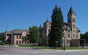 Lincoln County Courthouse in Canton
Verwaltung US-Bundesstaat: South Dakota Verwaltungssitz: Canton Gründung: 1887 Demographie Einwohner: 35.239 (2005) Bevölkerungsdichte: 23,5 Einwohner/km² Geographie Fläche gesamt: 1.499 km² Wasserfläche: 2 km² Karte 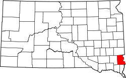
Lincoln County[1] ist ein County im Bundesstaat South Dakota der Vereinigten Staaten von Amerika. Er wurde nach dem früheren US-Präsidenten Abraham Lincoln benannt. Der Sitz der Countyverwaltung (County Seat) ist in Canton.
Inhaltsverzeichnis
Geographie
Das County hat eine Fläche von 1499 Quadratkilometern; davon sind 2 Quadratkilometer (0,09 Prozent) Wasserflächen. Er ist in 16 Townships: Brooklyn, Canton, Dayton, Delapre, Delaware, Eden, Grant, Fairview, Highland, La Valley, Lincoln, Lynn, Norway, Perry, Pleasant und Springdale.
Demographische Daten
Historische Einwohnerzahlen Census Einwohner ± in % 1900 12.161 — 1910 12.712 5 % 1920 13.893 9 % 1930 13.918 0,2 % 1940 13.171 -5 % 1950 12.767 -3 % 1960 12.371 -3 % 1970 11.761 -5 % 1980 13.942 20 % 1990 15.427 10 % 2000 24.131 60 % 2010 44.828 90 % 1900–1990[2] 2000[3]
Nach der Volkszählung im Jahr 2000 lebten 24.131 Menschen in dem County. Es gab 8.782 Haushalte und 6.665 Familien. Ethnisch betrachtet setzte sich die Bevölkerung zusammen aus 97,55 Prozent Weißen, 0,34 Prozent Afroamerikanern, 0,53 Prozent amerikanischen Ureinwohnern, 0,46 Prozent Asiaten und 0,31 aus anderen ethnischen Gruppen; 0,81 Prozent stammten von zwei oder mehr Ethnien ab. 0,7 Prozent der Bevölkerung waren spanischer oder lateinamerikanischer Abstammung.
Städte und Gemeinden
Städte (cities)
- Beresford
- Canton
- Harrisburg
- Lennox
- Sioux Falls (großteils in Minnehaha County)
- Tea
Gemeinden (towns)
- Fairview
- Hudson
- Worthing
andere Dorfer
- Moe
- Shindler
Einzelnachweise
- ↑ Lincoln County im Geographic Names Information System des United States Geological Survey. Abgerufen am 22. Februar 2011
- ↑ Auszug aus Census.gov. Abgerufen am 28. Februar 2011
- ↑ Auszug aus factfinder.census.gov Abgerufen am 28. Februar 2011

Liste der Countys in South Dakota
Aurora | Beadle | Bennett | Bon Homme | Brookings | Brown | Brule | Buffalo | Butte | Campbell | Charles Mix | Clark | Clay | Codington | Corson | Custer | Davison | Day | Deuel | Dewey | Douglas | Edmunds | Fall River | Faulk | Grant | Gregory | Haakon | Hamlin | Hand | Hanson | Harding | Hughes | Hutchinson | Hyde | Jackson | Jerauld | Jones | Kingsbury | Lake | Lawrence | Lincoln | Lyman | Marshall | McCook | McPherson | Meade | Mellette | Miner | Minnehaha | Moody | Pennington | Perkins | Potter | Roberts | Sanborn | Shannon | Spink | Stanley | Sully | Todd | Tripp | Turner | Union | Walworth | Yankton | Ziebach
Wikimedia Foundation.
Schlagen Sie auch in anderen Wörterbüchern nach:
Lincoln County, South Dakota — Infobox U.S. County county = Lincoln County state = South Dakota founded year = founded date = seat wl = Canton largest city wl = area total sq mi = 579 area total km2 = 1499 area land sq mi = 578 area land km2 = 1497 area water sq mi … Wikipedia
National Register of Historic Places listings in Lincoln County, South Dakota — Location of Lincoln County in South Dakota This is a list of the National Register of Historic Places listings in Lincoln County, South Dakota. This is intended to be a complete list of the properties and districts on the National Register of… … Wikipedia
Minnehaha County, South Dakota — Minnehaha County Courthouse in Sioux Falls, South Dakota … Wikipedia
Clay County, South Dakota — Location in the state of South Dakota … Wikipedia
Union County, South Dakota — Location in the state of South Dakota … Wikipedia
Ziebach County (South Dakota) — Verwaltung US Bundesstaat: South Dakota Verwaltungssitz: Dupree Adresse des Verwaltungssitzes: Gründung … Deutsch Wikipedia
Minnehaha County (South Dakota) — Verwaltung US Bundesstaat: South Dakota Verwaltungssitz: Sioux Falls Adresse des Verwaltungssitzes: Gründung … Deutsch Wikipedia
Turner County, South Dakota — Infobox U.S. County county = Turner County state = South Dakota founded year = founded date = seat wl = Parker largest city wl = area total sq mi = 617 area total km2 = 1599 area land sq mi = 617 area land km2 = 1598 area water sq mi = 1 area… … Wikipedia
Deuel County, South Dakota — Location in the state of South Dakota … Wikipedia
Douglas County, South Dakota — Douglas County Courthouse in Armour, South Dakota … Wikipedia
Lincoln County (South Dakota)


18+
© Academic, 2000-2024
- Kontaktieren Sie uns: Unterstützung, Werbung
Wörterbücher Export, schritte mit PHP, Joomla, Drupal, WordPress, MODx.