- Republican River
-
Republican River 
Karte des Republican River und seiner Zuflüsse
Daten Gewässerkennzahl US: 485443 Lage Nebraska, Kansas (USA) Flusssystem Mississippi River Abfluss über Kansas River → Missouri River → Mississippi River → Golf von Mexiko Ursprung Vereinigung von North Fork Republican River und Arikaree River im Dundy County
40° 1′ 12″ N, 101° 56′ 16″ W40.01999-101.93785988Quellhöhe 988 m Zusammenfluss mit dem Smoky Hill River bei Junction City zum Kansas River 39.0599979-96.8013971318Koordinaten: 39° 3′ 36″ N, 96° 48′ 5″ W
39° 3′ 36″ N, 96° 48′ 5″ W39.0599979-96.8013971318Mündungshöhe 318 m Höhenunterschied 670 m Länge 729 km[1] Rechte Nebenflüsse South Fork Republican River,
Arikaree RiverLinke Nebenflüsse North Fork Republican River Durchflossene Stauseen Swanson Reservoir,
Harlan County Reservoir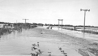
Hochwasser am 24. Juni 1947 am Republican River an der Grenze zwischen Jewell County und Republic County nahe Hardy und Webber.
Der Republican River ist ein Fluss in den zentralen Great Plains von Nordamerika. Er fließt 729 km[1] durch die US-Bundesstaaten Nebraska und Kansas.
Inhaltsverzeichnis
Geographie
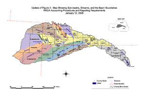 Republican River-Einzugsgebiet
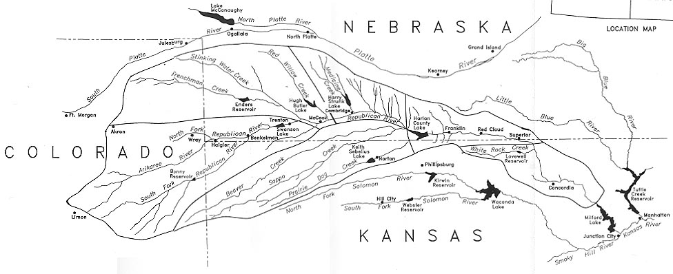
Der Republican River entsteht durch den Zusammenfluss von North Fork Republican River und Arikaree River nördlich von Haigler im Dundy County. Er vereinigt sich mit dem South Fork Republican River südöstlich von Benkelman. Alle drei Zuflüsse haben ihren Ursprung in den High Plains im nordöstlichen Colorado.[2][3][4] Der Republican River fließt überwiegend in östlicher Richtung entlang der Südgrenze von Nebraska, durchfließt das Swanson Reservoir und das Harlan County Reservoir bevor er sich nach Süden wendet und in die Smoky Hills-Region von Kansas gelangt. Der Republican River vereinigt sich mit dem Smoky Hill River bei Junction City zum Kansas River.
Einige Orte entlang des Flusslaufs sind: McCook, Clay Center, Concordia und Junction City. Nahe Concordia liegt die Republican River Pegram Truss, eine Brücke, die über den Republican River führt und im National Register of Historic Places geführt wird.
Geschichte
Der Fluss wurde nach einem Stamm der Pawnee-Indianer benannt, die als "die Republicans" bekannt waren (Stewart 1967:223).[5] Die Nutzung des Wassers des Republican River wird durch eine Vereinbarung der Staaten Nebraska, Kansas und Colorado, dem so genannten Republican River Compact, geregelt.
Einzelnachweise
- ↑ a b U.S. Geological Survey. National Hydrography Dataset high-resolution flowline data. The National Map, Abgerufen am 25. März 2011
- ↑ North Fork Republican River (Englisch). Geographic Names Information System. United States Geological Survey. Abgerufen am 1. Februar 2011.
- ↑ South Fork Republican River (Englisch). Geographic Names Information System. United States Geological Survey. Abgerufen am 1. Februar 2011.
- ↑ Arikaree River (Englisch). Geographic Names Information System. United States Geological Survey. Abgerufen am 1. Februar 2011.
- ↑ Stewart, George R. (1967) Names on the Land. Boston: Houghton Mifflin Company.
Weblinks
Kategorien:- Flusssystem Missouri River
- Fluss in Kansas
- Fluss in Nebraska
- Fluss in Nordamerika


Wikimedia Foundation.