- Verwaltungsgliederung von New York City
-
 Das Siegel von New York City
Die Verwaltungsgliederung von New York City erfolgt auf zwei Ebenen:
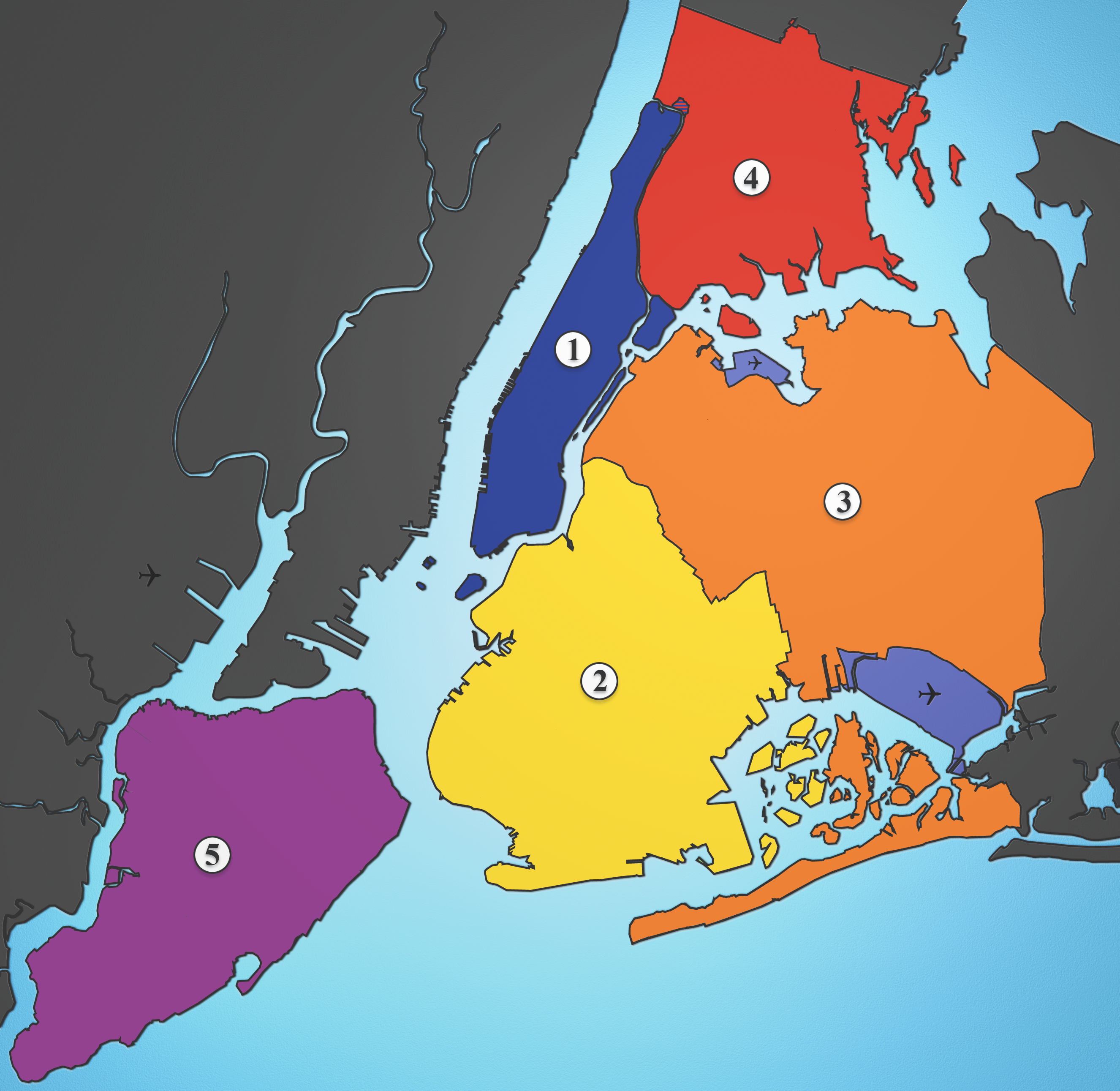
- Die Stadt New York ist unterteilt in fünf Boroughs („Stadtbezirke“), die den Countys („Landkreisen“) des Bundesstaates New York entsprechen.
- Die Boroughs wiederum gliedern sich in insgesamt 59 Community Districts (CD), deren Rolle im Kapitel 69 der Charter der City of New York festgelegt sind.
Die Community Districts nehmen allerdings kaum administrative Aufgaben im engeren Sinne wahr, sondern dienen hauptsächlich der verbesserten Mitsprache der Bürger. Jeder Community District hat ein Community Board mit bis zu 50 Mitgliedern, die Anwohner des jeweiligen Community Districts sein müssen und anteilig vom Borough President des jeweiligen Boroughs und dem lokalen Vertreter im Stadtrat (City Council) ernannt werden. Die Community Boards dienen als erste Anlaufstelle für Bürgerbeschwerden und haben ein Mitspracherecht bei Planungsvorhaben.
Überlagert werden die Grenzen der Community Districts von den Zuständigkeitsbereichen anderer städtischer Behörden, wie z. B. den Amtsbezirken (Precincts) von Feuerwehr und Polizei,[1] und den Schuldistrikten (School Districts)[2] die sich nur teilweise mit den Grenzen der Community Districts decken.
Die Community Districts wiederum bestehen aus verschiedenen Neighborhoods, weshalb New York auch als City of Neighborhoods Eingang in die Literatur gefunden hat. Die Neighborhoods sind allerdings keine festdefinierten Verwaltungseinheiten, sondern Bezeichnungen, die sich im Laufe der Zeit für einzelne Stadtteile herausgebildet haben. Viele dieser Neighborhoods gehen auf historische Ortschaften zurück, so z. B. das heutige Bushwick auf das 1661 von holländischen Siedlern gegründete Boswijck.[3] Andere gehen auf Immobilienspekulanten, die wesentlich an der Entwicklung des jeweiligen Stadtteils beteiligt waren zurück; Brownsville beispielsweise ist nach Charles S. Brown benannt, der die Gegend kaufte und nach 1865 250 Häuser dort errichtete.[4] Wieder andere Bezeichnungen gehen auf historische Einwanderergruppen zurück, wie z. B. Little Italy und Chinatown und einige neuere Bezeichnungen sind Erfindungen der Immobilienindustrie, um eine Gegend besser vermarkten zu können, so wie NoHo (North of Houston Street) oder DUMBO (Down Under the Manhattan Bridge Overpass). Neighborhoods zeichnen sich oft durch einen bestimmten, relativ einheitlichen architektonischen Stil oder eine bestimmte ethnische Zusammensetzung aus. Sie können mit Kiezen in Berlin verglichen werden.
Inhaltsverzeichnis
Boroughs/Counties
 5 Boroughs
Übersicht der Boroughs von New York City Jurisdiktion Einwohner Fläche Borough of… County of Schätzung
1. Juli 2008km² 1. Manhattan New York 1.634.795 59 2. Brooklyn Kings 2.556.598 183 3. Queens Queens 2.293.007 283 4. The Bronx Bronx 1.391.903 109 5. Staten Island Richmond 487.407 151 New York City 8.363.710 786 New York (Bundesstaat) 19.490.297 122.284 Quelle: United States Census Bureau [5][6][7] Community Districts
Die Einwohnerzahlen in der folgenden Tabelle beziehen sich auf die Volkszählung vom 1. April 2000.
Community Districts von New York City Community District
(CD)Fläche
km²Bev. Ew.
km²Neighborhoods Bronx CD 1 7,17 82.159 11.459 Mott Haven, Port Morris, Melrose Bronx CD 2 5,54 46.824 8.452 Longwood, Hunts Point Bronx CD 3 4,07 68.574 16.849 Claremont, Crotona Park, Concourse Village, Morrisania Bronx CD 4 5,28 139.563 26.432 Concourse, High Bridge Bronx CD 5 3,55 128.313 36.145 University Heights, Morris Heights, Mount Hope, Fordham Bronx CD 6 4,01 75.688 18.875 Belmont, Bathgate, West Farms, East Tremont Bronx CD 7 4,84 141.411 29.217 Norwood, University Heights, Bedford Park Bronx CD 8 8,83 101.332 11.476 Riverdale, Spuyten Duyvil, Van Cortlandt Village, Kingsbridge, Kingsbridge Heights, Fieldston, Marble Hill Bronx CD 9 12,41 167.859 13.526 Parkchester, Unionport, Soundview, Castle Hill, Bruckner, Harding Park, Bronx River, Clason Point Bronx CD 10 16,76 115.948 6.918 Co-op City, City Island, Throgs Neck, Westchester Square, Pelham Bay, Locust Point, Silver Beach Bronx CD 11 9,32 110.706 11.878 Morris Park, Pelham Parkway, Pelham Gardens, Allerton, Bronxdale, Laconia, Van Nest Bronx CD 12 14,56 149.077 10.239 Edenwald, Wakefield, Williamsbridge, Woodlawn, Fish Bay, Eastchester, Olinville, Baychester Brooklyn CD 1 12,82 160.338 12.507 Williamsburg, Greenpoint Brooklyn CD 2 7,72 98.620 12.775 Brooklyn Heights, DUMBO, Vinegar Hill, Fulton Mall, Boerum Hill, Fort Greene, Brooklyn Navy Yard, Fulton Ferry, Clinton Hill Brooklyn CD 3 7,67 143.867 18.757 Bedford-Stuyvesant, Stuyvesant Heights, Ocean Hill Brooklyn CD 4 5,31 104.358 19.653 Bushwick Brooklyn CD 5 14,61 173.198 11.855 East New York, Cypress Hills, Highland Park, New Lots, City Line, Starrett City Brooklyn CD 6 9,01 104.054 11.549 Red Hook, Carroll Gardens, Park Slope, Gowanus, Cobble Hill Brooklyn CD 7 10,96 120.063 10.955 Sunset Park, Windsor Terrace, Greenwood Heights Brooklyn CD 8 4,25 96.076 22.606 Crown Heights, Prospect Heights, Weeksville Brooklyn CD 9 4,07 104.014 25.556 Crown Heights, Prospect Lefferts Gardens, Wingate Brooklyn CD 10 10,57 122.542 11.593 Bay Ridge, Dyker Heights, Fort Hamilton Brooklyn CD 11 10,18 172.129 16.909 Bath Beach, Gravesend, Mapleton, Bensonhurst Brooklyn CD 12 9,32 185.046 19.855 Borough Park, Kensington, Ocean Parkway, Midwood Brooklyn CD 13 8,88 106.120 11.950 Coney Island, Brighton Beach, Bensonhurst, Gravesend, Seagate Brooklyn CD 14 7,61 168.806 22.182 Flatbush, Midwood, Kensington, Ocean Parkway Brooklyn CD 15 12,82 160.319 12.505 Sheepshead Bay, Manhattan Beach, Kings Bay, Gerritsen Beach, Kings Highway, East Gravesend, Madison, Homecrest, Plum Beach Brooklyn CD 16 4,97 85.343 17.172 Brownsville, Ocean Hill Brooklyn CD 17 8,73 165.753 18.987 East Flatbush, Remsen Village, Farragut, Rugby, Erasmus, Ditmas Village Brooklyn CD 18 24,68 194.653 7.887 Canarsie, Bergen Beach, Mill Basin, Flatlands, Marine Park, Georgetown, Mill Island Manhattan CD 1 4,45 34.420 7.735 TriBeCa, Battery Park City, Financial District Manhattan CD 2 4,01 93.119 23.222 Greenwich Village, West Village, NoHo, SoHo, Lower East Side, Chinatown, Little Italy Manhattan CD 3 4,56 164.407 36.054 Alphabet City, East Village, Lower East Side, Chinatown, Two Bridges Manhattan CD 4 5,41 87.479 16.170 Clinton, Chelsea Manhattan CD 5 4,25 44.028 10.360 Midtown Manhattan CD 6 3,55 136.152 38.353 Stuyvesant Town, Peter Cooper Village, Waterside Plaza, Tudor City, Turtle Bay, Murray Hill, Gramercy Park, Kips Bay, Sutton Place Manhattan CD 7 5,46 207.699 38.040 Manhattan Valley, Upper West Side, Lincoln Square Manhattan CD 8 5,13 217.063 42.312 Upper East Side, Lenox Hill, Yorkville, Roosevelt Island Manhattan CD 9 3,91 111.724 28.574 Hamilton Heights, Manhattanville, Morningside Heights Manhattan CD 10 3,63 107.109 29.507 Harlem, Polo Grounds Manhattan CD 11 5,75 117.743 20.477 East Harlem, Spanish Harlem, Wards Island, Randall’s Island Manhattan CD 12 7,64 208.414 27.279 Inwood, Washington Heights Queens CD 1 14,97 211.220 14.110 Astoria, Old Astoria, Long Island City, Queensbridge, Ditmars, Ravenswood, Steinway, Garden Bay, Woodside, Rikers Island (obwohl Teil der Bronx) Queens CD 2 13,36 109.920 8.228 Hunters Point, Long Island City, Woodside, Sunnyside Queens CD 3 7,33 169.083 23.067 Jackson Heights, East Elmhurst, North Corona Queens CD 4 6,16 167.005 27.111 Elmhurst, Corona, Roosevelt Avenue Queens CD 5 19,63 165.911 8.452 Ridgewood, Glendale, Middle Village, Maspeth, Fresh Pond, Liberty Park Queens CD 6 7,59 115.967 15.279 Forest Hills, Rego Park Queens CD 7 32,97 242.952 7.369 Flushing, Bay Terrace, College Point, Whitestone, Malba, Linden Hill, Beechhurst, Queensboro Hill, Willets Point Queens CD 8 19,17 146.594 7.647 Fresh Meadows, Cunningham Heights, Hilltop Village, Pomonak Houses, Fresh Meadows, Jamaica Estates, Holliswood, Flushing South, Utopia, Kew Gardens Hills, Briarwood Queens CD 9 10,08 141.608 14.048 Richmond Hill, Woodhaven, Ozone Park, Kew Gardens Queens CD 10 16,19 127.274 7.861 Howard Beach, South Ozone Park, Richmond Hill, Tudor Village, Lindenwood Queens CD 11 24,99 116.404 4.658 Bayside, Douglaston, Little Neck, Auburndale, East Flushing, Oakland Gardens, Hollis Hills Queens CD 12 25,46 223.602 8.782 Jamaica, Hollis, Saint Albans, Springfield Gardens, Baisley Park, Rochdale Village, South Jamaica Queens CD 13 33,31 196.284 5.893 Queens Village, Glen Oaks, New Hyde Park, Bellerose, Cambria Heights, Laurelton, Rosedale, Meadowmere, Floral Park, Brookville Queens CD 14 23,28 106.686 4.583 Breezy Point, Belle Harbor, Neponsit, Arverne, Bayswater, Edgemere, Rockaway Park, Rockaway, Far Rockaway Staten Island CD 1 36,62 162.609 4.440 Arlington, Castleton Corners, Clifton, Concord, Elm Park, Fort Wadsworth, Graniteville, Grymes Hill, Livingston, Mariners Harbor, Meiers Corners, New Brighton, Port Ivory, Port Richmond, Randall Manor, Rosebank, St. George, Shore Acres, Silver Lake, Stapleton, Sunnyside, Tompkinsville, West Brighton, Westerleigh Staten Island CD 2 54,62 127.071 2.326 Arrochar, Bloomfield, Bulls Heads, Chelsea, Dongan Hills, Egbertville, Emerson Hill, Grant City, Grasmere, Midland Beach, New Dorp, New Springville, Oakwood, Ocean Breeze, Old Town, South Beach, Todt Hill, Travis Staten Island CD 3 58,97 152.908 2.593 Annadale, Arden Heights, Bay Terrace, Charleston, Eltingville, Great Kills, Greenridge, Huguenot, Pleasant Plains, Prince’s Bay, Richmond Valley, Rossville, Tottenville, Woodrow New York City 831,39 8.008.278 9.632 Quelle: Department of City Planning, City of New York
Neighborhoods
- siehe hierzu auch: Liste der Viertel Manhattans
Einzelne neighboorhoods werden von Einwohnern unterschiedlicher Abstammung charakterisiert:
African American
- Brooklyn: Fort Greene; Flatbush; Canarsie; Bedford Stuyvesant; Weeksville; Brownsville; East New York; Starrett City; Ocean Hill; East Flatbush; City Line; Clinton Hill; Cypress Hills; Kensington; Flatlands; Stuyvesant Heights and Wingate
- Bronx: Co-op City; Baychester; Eastchester; Edenwald; Soundview; Wakefield; Williamsbridge; Olinville; Allerton; Concouse; Fordham-Bedford; Mott Haven;Morrisania; Tremont; Highbridge and East Morrisania
- Manhattan: Harlem; Sugar Hill; Hamilton Heights; Hudson Heights; Lower East Side and San Juan Hill
- Staten Island: Mariners Harbor; Tompkinsville; Clifton and Stapleton
- Queens: Far Rockaway; Arverne; St. Albans; Cambria Heights; Laurelton; Rosedale; Jamaica; Hollis; South Jamaica; Elmhurst; Ozone Park; South Ozone Park; Springfield Gardens; Queensbridge; East Elmhurst and Queens Village
Hispanic
- Brooklyn: Bushwick; Williamsburg; East Williamsburg; East New York; Sunset Park; Cypress Hills; New Lots; Kensington and City Line
- Bronx: Allerton; Bedford Park; Castle Hill; Concourse, Bronx; East Morrisania, Bronx; East Tremont, Bronx; Fordham, Bronx; Fordham-Bedford, Bronx; Harding Park, Bronx; Highbridge, Bronx; Hunts Point, Bronx; The Hub, Bronx; Kingsbridge, Bronx; Kingsbridge Heights, Bronx; Longwood, Bronx; Melrose, Bronx; Morrisania, Bronx; Morris Heights, Bronx; Mott Haven, Bronx; Norwood, Bronx; Port Morris, Bronx; Soundview, Bronx; Tremont, Bronx; University Heights, Bronx and West Farms, Bronx
- Manhattan: Spanish Harlem, Manhattan; Inwood, Manhattan; Washington Heights, Manhattan; Lower East Side, Manhattan; Alphabet City, Manhattan; Lower East Side, Manhattan; East Village, Manhattan; Loisaida; Manhattan; Hamilton Heights, Manhattan; Manhattanville, Manhattan; Hudson Heights, Manhattan and Manhattan Valley; Manhattan
- Staten Island: Mariners Harbor; Tompkinsville; Port Richmond; Clifton and Midland Beach
- Queens: Elmhurst; Corona; East Elmhurst; Woodhaven; Woodside; Flushing; Maspeth; Ridgewood; Ozone Park; South Ozone Park; Glendale; Jackson Heights; North Corona; Utopia; Richmond Hill; Sunnyside; Astoria; Queens Village and Linden Hill, Kew Gardens
Italienisch
- Brooklyn: Bensonhurst; Dyker Heights; Midwood; Bay Ridge; Cobble Hill; Carroll Gardens; Gravesend; Homecrest; Manhattan Beach; Mill Basin; Marine Park and Kensington
- Bronx: Country Club; Morris Park; City Island; Arthur Avenue Pelham Bay; Pelham Gardens; Pelham Parkway; Throgs Neck; Locust Point and Woodlawn
- Manhattan: Hell's Kitchen; Little Italy; NoLIta; Greenwich Village; Lower East Side and Italian Harlem
- Staten Island: Annadale; Arden Heights; Arrochar; Bay Terrace; Charleston; Concord; Eltingville; Grant City; Grasmere; Great Kills; Greenridge; Huguenot; New Dorp; New Springville; Pleasant Plains; Port Richmond; Prince's Bay; Rosebank; South Beach; Todt Hill; Tompkinsville; Tottenville; West New Brighton and Willowbrook
- Queens: Howard Beach; Old Howard Beach; Ozone Park; Middle Village; Bayside; Richmond Hill; South Ozone Park; Whitestone; Murray Hill; Rockwood Park; Jackson Heights; Woodhaven; Ridgewood; Tudor Village; Lindenwood and Broad Channel
Jüdisch
- Brooklyn: Midwood; Borough Park; Gravesend; Sheepshead Bay; Homecrest; Marine Park; Brighton Beach; Coney Island; Park Slope; Crown Heights; Mill Basin; Marine Park; Bensonhurst; Williamsburg; Flatbush and Kings Highway
- Bronx: Riverdale; Pelham Parkway; Van Cortlandt Village and City Island
- Manhattan: Upper East Side; Lower East Side; Greenwich Village; Morningside Heights and TriBeCa
- Queens: Little Neck; Forest Hills; Fresh Meadows; Bayside; Woodhaven; Rockwood Park; Briarwood; Kew Gardens; Jamaica Estates; Hillcrest; Douglaston; Bayswater; Utopia; Jackson Heights; Hollis Hills; Glendale; Lindenwood; Howard Beach and Forest Hills Gardens
Guyanisch
- Queens: Kew Gardens; Richmond Hill;
Siehe auch
Einzelnachweise
- ↑ NYPD - Precinct Maps
- ↑ NYC Department of Education Maps
- ↑ Kenneth T. Jackson, John B. Manbeck: The Neighborhoods of Brooklyn. New Haven, London 1998, S. 44.
- ↑ Kenneth T. Jackson, John B. Manbeck: The Neighborhoods of Brooklyn. New Haven, London 1998, S. 40.
- ↑ American Fact Finder (U.S. Census Bureau): Table GCT-T1, 2008 Population Estimates for New York State by County, retrieved on May 15, 2009
- ↑ County and City Data Book:2007 Table B-1, Area and Population, retrieved on July 12, 2008. New York County (Manhattan) was the nation's densest-populated county, followed by Kings County (Brooklyn), Bronx County, Queens County and San Francisco, California.
- ↑ American Fact Finder (U.S. Census Bureau): New York by County - Table GCT-PH1. Population, Housing Units, Area, and Density: 2000 Data Set: Census 2000 Summary File 1 (SF 1) 100-Percent Data, retrieved on February 6, 2009
Weblinks
Kategorien:- Verwaltungsgliederung nach Ort
- Stadtteil (New York City)
- Stadtbezirk von New York City
- Liste (Stadtteile)
- Verwaltungsgliederung der Vereinigten Staaten

Wikimedia Foundation.