- Oyabe
-
Oyabe-shi
小矢部市

Geographische Lage in Japan Region: Chūbu Präfektur: Toyama Koordinaten: 36° 41′ N, 136° 52′ O36.675555555556136.86861111111Koordinaten: 36° 40′ 32″ N, 136° 52′ 7″ O Basisdaten Fläche: 134,11 km² Einwohner: 31.778
(1. Juli 2011)Bevölkerungsdichte: 237 Einwohner je km² Gemeindeschlüssel: 16209-4 Symbole Baum: Miyajima-Sicheltanne Blume: Japanische Sumpf-Schwertlilie Baumblüte: rote Ume-Blüten Rathaus Adresse: Oyabe City Hall
1-1, Hon-machi
Oyabe-shi
Toyama 932-8611Webadresse: http://www.city.oyabe.toyama.jp Lage Oyabes in der Präfektur Toyama 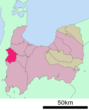
Oyabe (jap. 小矢部市, -shi) ist eine Stadt in der Präfektur Toyama in Japan.
Inhaltsverzeichnis
Geographie
Oyabe liegt westlich von Toyama und südwestlich von Takaoka.
Geschichte
Die Stadt Oyabe wurde am 1. Oktober 1958 gegründet.
Verkehr
- Straße:
- Hokuriku-Autobahn
- Nationalstraße 8, nach Kyoto und Niigata
- Nationalstraße 359, nach Toyama und Kanazawa
- Nationalstraße 471, nach Hakui und Takayama
- Zug:
Angrenzende Städte und Gemeinden
- Präfektur Toyama
- Präfektur Ishikawa
- Kanazawa
- Tsubata
Weblinks
 Commons: Oyabe – Sammlung von Bildern, Videos und Audiodateien
- Offizielle Website auf Japanisch
Schlagen Sie auch in anderen Wörterbüchern nach:
Oyabe — may refer to: Oyabe, Gabon Oyabe, Toyama, Japan This disambiguation page lists articles associated with the same title. If an internal link led you here, you may wish to change the link to point directly to the intende … Wikipedia
Oyabe — Original name in latin Oyabe Name in other language Oyabe, xiao shi bu State code JP Continent/City Asia/Tokyo longitude 36.66667 latitude 136.85 altitude 66 Population 0 Date 2012 08 26 … Cities with a population over 1000 database
Oyabe River — (Oyabe gawa) 小矢部川 River Name origin: Ainu … Wikipedia
Oyabe, Toyama — For the Oyabe in Gabon, see Oyabe, Gabon. Oyabe 小矢部市 City … Wikipedia
Oyabe, Gabon — There is also an Oyabe in Japan, see Oyabe, Toyama Oyabe … Wikipedia
Oyabe-shi — Admin ASC 2 Code Orig. name Oyabe shi Country and Admin Code JP.42.1853505 JP … World countries Adminstrative division ASC I-II
Nishitonami District, Toyama — Nishitonami (西礪波郡; gun) is a district located in Toyama, Japan. As of November 1, 2004, the district has a population of 13,770. The total area was 58.76 km². Prior to dissolution, the district has only one town left. Fukuoka Due to the… … Wikipedia
Takaoka — shi 高岡市 … Deutsch Wikipedia
Hiroshi Hase — Infobox Wrestler name=Hiroshi Hase names=Hiroshi Hase height=186 cm (6 ft 1 in) weight=106 kg (233 lb) birth date=Birth date and age|1961|5|5 death date= birth place=Oyabe, Toyama, Japan death place= resides= billed= trainer=Riki Chōshū Stu Hart… … Wikipedia
Tōkai-Hokuriku Expressway — Infobox road highway name = Tōkai Hokuriku Expressway (東海北陸自動車道) marker length = 185 km established = 1986 [cite web| url= http://www.tokai kansen.go.jp/naruhodo/jisendo/2006 07/p03 04.html | title= History of the Expressway Network in the… … Wikipedia
- Straße:
Oyabe


18+
© Academic, 2000-2024
- Kontaktieren Sie uns: Unterstützung, Werbung
Wörterbücher Export, schritte mit PHP, Joomla, Drupal, WordPress, MODx.