- Mercury Islands
-
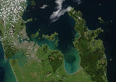
Mercury Islands Eine Echtfarbenaufnahme des NASA-Satelliten Terra vom 23. Oktober 2002, die Mercury Islands liegen ganz oben rechts, nordöstlich der Coromandel-Halbinsel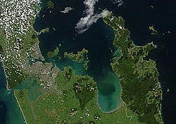
Gewässer Pazifischer Ozean Geographische Lage 36° 38′ S, 175° 49′ O-36.633333333333175.81666666667Koordinaten: 36° 38′ S, 175° 49′ O 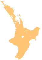

Anzahl der Inseln 7 Hauptinsel Great Mercury Island Gesamtfläche Die Mercury Islands sind eine Inselgruppe vor der Nordostküste der Nordinsel Neuseelands. Gelegentlich wird auch noch der frühere Name Iles d'Hausse verwendet. Sie liegen 8 km vor der Küste der Coromandel-Halbinsel und 35 km nordöstlich von Whitianga und gehören administrativ zur Region Waikato.
Die Hauptkette der Mercury Islands besteht aus Great Mercury Island, auch auf Maori als Ahuahu bekannt im Westen und Red Mercury Island im Osten sowie 5 viel kleineren Inseln zwischen ihnen. Nur Great Mercury Island ist bewohnt, die anderen sind Teil eines Naturschutzgebietes. Südlich der Hauptkette liegen nördlich der Mündung der Mercury Bay noch zahlreiche weitere Inselchen. Eine weitere, einzeln stehende Insel, Cuvier Island, liegt 15 km nördlich von Great Mercury Island. Sie wird aber normalerweise nicht als Teil der Inselgruppe gezählt. Great Mercury Island ist der Überrest eines Rhyolith-Vulkans aus dem Pliozän.
Great Mercury Island ist Privateigentum von Michael Fay, einem früher prominenten neuseeländischen Geschäftsmann, der in der Schweiz lebt. Auf der Insel befinden sich zwei luxuriöse Anwesen, die vermietet werden.
Von Great Mercury Island aus startete am 30. November 2009 die Firma Rocket Lab eine Rakete vom Typ Ātea-1, die offenbar über 100 km Höhe erreichte, und damit in den Weltraum vorstieß.[1]
Einzelnachweise
- Geology – New Zealand's Geological History', aus An Encyclopaedia of New Zealand, Hrsg. A. H. McLintock, 1966. Te Ara - The Encyclopedia of New Zealand (Stand: 15. April 2005).
- ↑ Alexis Madrigal: Kiwi Rocket Scares Sheep, Reaches Space. Wired.com, 30. November 2009, abgerufen am 29. Dezember 2009 (englisch).
Kategorien:- Inselgruppe (Neuseeland)
- Inselgruppe (Australien und Ozeanien)
- Inselgruppe (Pazifischer Ozean)
- Unbewohnte Inselgruppe

Wikimedia Foundation.