- Marion County (Mississippi)
-
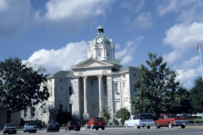
Verwaltung US-Bundesstaat: Mississippi Verwaltungssitz: Columbia Adresse des
Verwaltungssitzes:County Courthouse
215 Broad Street
Columbia, MS 39429-2904Gründung: 9. Dezember 1811 Gebildet aus: Amite County
Franklin County
Wayne CountyVorwahl: 001 601 Demographie Einwohner: 27.088 (2010) Bevölkerungsdichte: 19,3 Einwohner/km² Geographie Fläche gesamt: 1.421 km² Wasserfläche: 16 km² Karte 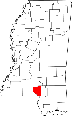
Das Marion County[2] ist ein County im Bundesstaat Mississippi in den Vereinigten Staaten von Amerika. Bei der Volkszählung im Jahr 2010 hatte das County 27.088 Einwohner und eine Bevölkerungsdichte von 19,3 Einwohnern pro Quadratkilometer. Der Verwaltungssitz (County Seat) ist Columbia.
Inhaltsverzeichnis
Geografie
Das County liegt im Süden von Mississippi, grenzt mit seiner Südspitze an Louisiana, ist etwa 90 km vom Golf von Mexiko entfernt und hat eine Fläche von 1421 Quadratkilometern, wovon 16 Quadratkilometer Wasserfläche sind. Es grenzt an folgende Countys und Parishes:
Lawrence County Jefferson Davis County Walthall County 
Lamar County Washington Parish
(Louisiana)Pearl River County Geschichte
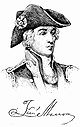 F. Marion
Das Marion County wurde am 9. Dezember 1811 aus Teilen des Amite-, Franklin- und Wayne County gebildet. Benannt wurde es nach Francis Marion, einem General im Amerikanischen Unabhängigkeitskrieg.
Demografische Daten
Historische Einwohnerzahlen Census Einwohner ± in % 1820 3116 — 1830 3691 20 % 1840 3830 4 % 1850 4410 20 % 1860 4686 6 % 1870 4211 -10 % 1880 6901 60 % 1890 9532 40 % 1900 13.501 40 % 1910 15.599 20 % 1920 17.144 10 % 1930 19.923 20 % 1940 24.085 20 % 1950 23.967 -0,5 % 1960 23.293 -3 % 1970 22.871 -2 % 1980 25.708 10 % 1990 25.544 -0,6 % 2000 25.595 0,2 % 2010 27.088 6 % Vor 1900[3] 1900–1990[4] 2000[5] 2010[6] 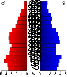 Alterspyramide des Marion County
Nach der Volkszählung im Jahr 2000 lebten im Marion County 25.595 Menschen in 9.336 Haushalten und 6.880 Familien. Die Bevölkerungsdichte betrug 18 Personen pro Quadratkilometer. Ethnisch betrachtet setzte sich die Bevölkerung zusammen aus 66,96 Prozent Weißen, 31,87 Prozent Afroamerikanern, 0,23 Prozent amerikanischen Ureinwohnern, 0,21 Prozent Asiaten, 0,01 Prozent Bewohnern aus dem pazifischen Inselraum und 0,11 Prozent aus anderen ethnischen Gruppen; 0,62 Prozent stammten von zwei oder mehr Ethnien ab. 0,62 Prozent der Bevölkerung waren spanischer oder lateinamerikanischer Abstammung, die verschiedenen der genannten Gruppen angehörten.
Von den 9.336 Haushalten hatten 34,8 Prozent Kinder unter 18 Jahren, die mit ihnen lebten. 54,0 Prozent waren verheiratete, zusammenlebende Paare, 15,6 Prozent waren allein erziehende Mütter und 26,3 Prozent waren keine Familien. 24,2 Prozent aller Haushalte waren Singlehaushalte und in 12,6 Prozent lebten Menschen im Alter von 65 Jahren oder darüber. Die durchschnittliche Haushaltsgröße lag bei 2,64 und die durchschnittliche Familiengröße bei 3,13 Personen.
27,8 Prozent der Bevölkerung war unter 18 Jahre alt, 9,5 Prozent zwischen 18 und 24, 26,9 Prozent zwischen 25 und 44, 21,5 Prozent zwischen 45 und 64 Jahre alt und 14,3 Prozent waren 65 Jahre oder älter. Das Durchschnittsalter betrug 35 Jahre. Auf 100 weibliche kamen statistisch 93,7 männliche Personen und auf 100 Frauen im Alter von 18 Jahren oder darüber kamen 88,8 Männer.
Das durchschnittliche Einkommen eines Haushaltes betrug 24.555 USD, das einer Familie 29.894 USD. Männer hatten ein durchschnittliches Einkommen von 26.909 USD, Frauen 17.192 USD. Das Pro-Kopf-Einkommen lag bei 12.301 USD. Etwa 20,7 Prozent der Familien und 24,8 Prozent der Bevölkerung lebten unterhalb der Armutsgrenze.[7]
Städte und Gemeinden
- Bunker Hill
- Cheraw
- Columbia
- East Columbia
- Foxworth
- Goss
- Hub
- Improve
- Kokomo
- Morgantown
- Sandy Hook
- Jamestown
Einzelnachweise
- ↑ Auszug aus dem National Register of Historic Places - Nr. 95000178 Abgerufen am 27. Juni 2011
- ↑ GNIS-ID: 695769. Abgerufen am 22. Februar 2011 (englisch).
- ↑ U.S. Census Bureau _ Census of Population and Housing Abgerufen am 19. Februar 2011
- ↑ Auszug aus Census.gov Abgerufen am 19. Februar 2011
- ↑ Auszug aus factfinder.census.gov Abgerufen am 18. Februar 2011
- ↑ United States Census 2010 Abgerufen am 27. Juni 2011
- ↑ Marion County, Mississippi Datenblatt mit den Ergebnissen der Volkszählung im Jahre 2000 bei factfinder.census.gov
Weblinks
-
 Commons: Marion County, Mississippi – Sammlung von Bildern, Videos und Audiodateien
 - Marion County Development Partnership
- Local Governments - Marion County
- Fotos des Bezirksgerichts
- www.city-data.com

Liste der Countys in Mississippi
Adams | Alcorn | Amite | Attala | Benton | Bolivar | Calhoun | Carroll | Chickasaw | Choctaw | Claiborne | Clarke | Clay | Coahoma | Copiah | Covington | DeSoto | Forrest | Franklin | George | Greene | Grenada | Hancock | Harrison | Hinds | Holmes | Humphreys | Issaquena | Itawamba | Jackson | Jasper | Jefferson | Jefferson Davis | Jones | Kemper | Lafayette | Lamar | Lauderdale | Lawrence | Leake | Lee | Leflore | Lincoln | Lowndes | Madison | Marion | Marshall | Monroe | Montgomery | Neshoba | Newton | Noxubee | Oktibbeha | Panola | Pearl River | Perry | Pike | Pontotoc | Prentiss | Quitman | Rankin | Scott | Sharkey | Simpson | Smith | Stone | Sunflower | Tallahatchie | Tate | Tippah | Tishomingo | Tunica | Union | Walthall | Warren | Washington | Wayne | Webster | Wilkinson | Winston | Yalobusha | Yazoo
Wikimedia Foundation.
Schlagen Sie auch in anderen Wörterbüchern nach:
Marion County, Mississippi — For counties with the same, see Marion County (disambiguation). Marion County, Mississippi Marion County courthouse in Columbia, Mississippi … Wikipedia
Marion County Courthouse — or Old Marion County Courthouse may refer to: Marion County Courthouse (Arkansas), Yellville, Arkansas, listed on the NRHP in Marion County, Arkansas Marion County Courthouse (Buena Vista, Georgia), listed on the NRHP in Marion County, Georgia… … Wikipedia
Marion County — is the name of seventeen counties in the United States of America, mostly named for General Francis Marion: Marion County, Alabama Marion County, Arkansas Marion County, Florida Marion County, Georgia Marion County, Illinois Marion County,… … Wikipedia
Marion County School District (Mississippi) — The Marion County School District is a public school district based in Marion County, Mississippi (USA). Contents 1 Schools 1.1 High Schools (Grades 7 12) 1.2 Elementary Schools (Grades 4 6) … Wikipedia
Marion County — Es gibt in den Vereinigten Staaten 17 Countys mit dem Namen Marion County: Marion County (Alabama) Marion County (Arkansas) Marion County (Florida) Marion County (Georgia) Marion County (Illinois) Marion County (Indiana) Marion County (Iowa)… … Deutsch Wikipedia
Marion County Courthouse (Ohio) — Marion County Courthouse U.S. National Register of Historic Places … Wikipedia
Marion County Courthouse — bezeichnet mehrere gleichnamige, im NRHP gelistete, Objekte: Marion County Courthouse (Arkansas), ID Nr. 94000471 Marion County Courthouse (Georgia), ID Nr. 80001115 Marion County Courthouse (Iowa), ID Nr. 81000256 Marion County Courthouse… … Deutsch Wikipedia
Marion County Courthouse (Iowa) — Marion County Courthouse U.S. National Register of Historic Places … Wikipedia
Marion County, Alabama — For counties with a similar name, see Marion County (disambiguation). Marion County, Alabama Location in the state of Alabama … Wikipedia
Marion County, Missouri — For counties with a similar name, see Marion County (disambiguation). Marion County, Missouri Location in the state of Missouri … Wikipedia
Marion County (Mississippi)


18+
© Academic, 2000-2024
- Kontaktieren Sie uns: Unterstützung, Werbung
Wörterbücher Export, schritte mit PHP, Joomla, Drupal, WordPress, MODx.