- Laurens County (South Carolina)
-
Verwaltung US-Bundesstaat: South Carolina Verwaltungssitz: Laurens Adresse des
Verwaltungssitzes:County Courthouse
P.O. Box 445
Laurens, SC 29360-0445Gründung: 1785 Vorwahl: 001 864 Demographie Einwohner: 70.293 (2005) Bevölkerungsdichte: 38 Einwohner/km² Geographie Fläche gesamt: 1.875 km² Wasserfläche: 23 km² Karte 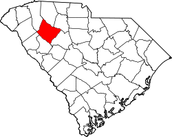
Website: www.laurenscountysc.org Laurens County[1] ist ein County im Bundesstaat South Carolina der Vereinigten Staaten von Amerika. Der Verwaltungssitz (County Seat) ist Laurens.
Inhaltsverzeichnis
Geografie
Das County liegt im mittleren Nordwesten von South Carolina und hat eine Fläche von 1875 Quadratkilometern, wovon 23 Quadratkilometer Wasserfläche sind. Es grenzt im Uhrzeigersinn an folgende Countys: Spartanburg County, Union County, Newberry County, Greenwood County, Abbeville County, Anderson County und Greenville County.
Geschichte
Laurens County wurde 1785 gebildet. Benannt wurde es nach Henry Laurens, dem dritten Präsidenten des Kontinentalkongresses.
Demografische Daten
Historische Einwohnerzahlen Census Einwohner ± in % 1790 9337 — 1800 12.809 40 % 1810 14.982 20 % 1820 17.682 20 % 1830 20.863 20 % 1840 21.584 3 % 1850 23.407 8 % 1860 23.858 2 % 1870 22.536 -6 % 1880 29.444 30 % 1890 31.610 7 % 1900 37.382 20 % 1910 41.550 10 % 1920 42.560 2 % 1930 42.094 -1 % 1940 44.185 5 % 1950 46.974 6 % 1960 47.609 1 % 1970 49.713 4 % 1980 52.214 5 % 1990 58.092 10 % 2000 69.567 20 % Vor 1900[2] Nach der Volkszählung im Jahr 2000 lebten im Laurens County 69.567 Menschen in 26.290 Haushalten und 18.876 Familien. Die Bevölkerungsdichte betrug 38 Einwohner pro Quadratkilometer. Ethnisch betrachtet setzte sich die Bevölkerung zusammen aus 71,57 Prozent Weißen, 26,23 Prozent Afroamerikanern, 0,28 Prozent amerikanischen Ureinwohnern, 0,15 Prozent Asiaten, 0,05 Prozent Bewohnern aus dem pazifischen Inselraum und 0,95 Prozent aus anderen ethnischen Gruppen; 0,78 Prozent stammten von zwei oder mehr Ethnien ab. 1,94 Prozent der Bevölkerung waren spanischer oder lateinamerikanischer Abstammung.
Von den 26.290 Haushalten hatten 32,5 Prozent Kinder unter 18 Jahre, die bei ihnen lebten. 51,1 Prozent waren verheiratete, zusammenlebende Paare, 15,6 Prozent waren allein erziehende Mütter, 28,2 Prozent waren keine Familien, 24,6 Prozent waren Singlehaushalte und in 9,8 Prozent lebten Menschen mit 65 Jahren oder darüber. Die Durchschnittshaushaltsgröße betrug 2,55 und die durchschnittliche Familiengröße betrug 3,01 Personen.
25,3 Prozent der Bevölkerung war unter 18 Jahre alt. 9,2 Prozent zwischen 18 und 24, 28,5 Prozent zwischen 25 und 44, 23,8 Prozent zwischen 45 und 64 und 13,2 Prozent waren 65 Jahre alt oder älter. Das Durchschnittsalter betrug 36 Jahre. Auf 100 weibliche Personen kamen 93,6 männliche Personen und auf 100 Frauen im Alter von 18 Jahren und darüber kamen 89,7 Männer.
Das jährliche Durchschnittseinkommen eines Haushalts betrug 33.933 USD, das Durchschnittseinkommen einer Familie betrug 39.739 USD. Männer hatten ein Durchschnittseinkommen von 30.402 USD, Frauen 21.684 USD. Das Prokopfeinkommen betrug 15.761 USD. 11,6 Prozent der Familien und 14,3 Prozent der Bevölkerung lebten unterhalb der Armutsgrenze. [5]
Siehe auch
Einzelnachweise
- ↑ Laurens County im Geographic Names Information System des United States Geological Survey. Abgerufen am 22. Februar 2011
- ↑ U.S. Census Bureau - Census of Population and Housing. Abgerufen am 15. März 2011
- ↑ Auszug aus Census.gov. Abgerufen am 28. Februar 2011
- ↑ Auszug aus factfinder.census.gov Abgerufen am 28. Februar 2011
- ↑ Laurens County, South Carolina, Datenblatt mit den Ergebnissen der Volkszählung im Jahre 2000 bei factfinder.census.gov.

Liste der Countys in South Carolina
Abbeville | Aiken | Allendale | Anderson | Bamberg | Barnwell | Beaufort | Berkeley | Calhoun | Charleston | Cherokee | Chester | Chesterfield | Clarendon | Colleton | Darlington | Dillon | Dorchester | Edgefield | Fairfield | Florence | Georgetown | Greenville | Greenwood | Hampton | Horry | Jasper | Kershaw | Lancaster | Laurens | Lee | Lexington | Marion | Marlboro | McCormick | Newberry | Oconee | Orangeburg | Pickens | Richland | Saluda | Spartanburg | Sumter | Union | Williamsburg | York
Wikimedia Foundation.
Schlagen Sie auch in anderen Wörterbüchern nach:
Laurens County, South Carolina — Infobox U.S. County county = Laurens County state = South Carolina map size = 200 founded = 1785 seat = Laurens | area total sq mi =724 area land sq mi =715 area water sq mi =9 area percentage = 1.23% census yr = 2000 pop = 69567 density km2 =38… … Wikipedia
National Register of Historic Places listings in Laurens County, South Carolina — Location of Laurens County in South Carolina This is a list of the National Register of Historic Places listings in Laurens County, South Carolina. This is intended to be a complete list of the properties and districts on the National Register of … Wikipedia
Newberry County, South Carolina — Location in the state of South Carolina … Wikipedia
Abbeville County, South Carolina — Infobox U.S. County county = Abbeville County state = South Carolina map size = 200 founded = 1785 seat = Abbeville | area total sq mi =511 area land sq mi =508 area water sq mi =3 area percentage = 0.59% census yr = 2000 pop = 26167 density km2 … Wikipedia
Anderson County, South Carolina — Infobox U.S. County county = Anderson County state = South Carolina map size = 200 founded = 1826 seat = Anderson area total sq mi =757 area land sq mi =718 area water sq mi =39 area percentage = 5.21% census yr = 2000 pop = 173550 density km2… … Wikipedia
Union County, South Carolina — Infobox U.S. County county = Union County state = South Carolina map size = 200 founded = 1798 seat = Union | area total sq mi =516 area land sq mi =514 area water sq mi =2 area percentage = 0.35% census yr = 2000 pop = 29881 density km2 =22 web … Wikipedia
Greenville County, South Carolina — Infobox U.S. County county = Greenville County state = South Carolina map size = 225 founded = 1786 seat = Greenville | area total sq mi =795 area land sq mi =790 area water sq mi =5 area percentage = 0.61% census yr = 2008 pop = +420,000 density … Wikipedia
Spartanburg County, South Carolina — Infobox U.S. County county = Spartanburg County state = South Carolina map size = 200 founded = 1785 seat = Spartanburg | area total sq mi =819 area land sq mi =811 area water sq mi =8 area percentage = 1.00% census yr = 2000 pop = 253791 density … Wikipedia
Greenwood County, South Carolina — Infobox U.S. County county = Greenwood County state = South Carolina map size = 200 founded = 1897 seat = Greenwood | area total sq mi =463 area land sq mi =456 area water sq mi =7 area percentage = 1.60% census yr = 2000 pop = 66271 density km2 … Wikipedia
Anderson County (South Carolina) — Verwaltung US Bundesstaat: South Carolina Verwaltungssitz: Anderson Adresse des Verwaltungssitzes: County Courthouse P.O. Box 8002 Anderson, SC 29622 8002 Gründung: 20. Dezember 1826 … Deutsch Wikipedia
Laurens County (South Carolina)

18+
© Academic, 2000-2024
- Kontaktieren Sie uns: Unterstützung, Werbung
Wörterbücher Export, schritte mit PHP, Joomla, Drupal, WordPress, MODx.