Kimball (South Dakota)

Kimball (South Dakota)
Icon tools.svg Dieser Artikel wurde aufgrund von inhaltlichen Mängeln auf der Qualitätssicherungsseite des Projektes USA eingetragen. Hilf mit, die Qualität dieses Artikels auf ein akzeptables Niveau zu bringen, und beteilige dich an der Diskussion!
US-GreatSeal-Obverse.svg
Kimball
Brule County South Dakota Incorporated and Unincorporated areas Kimball Highlighted.svg
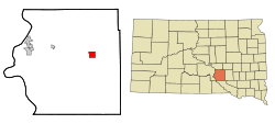
Lage in South Dakota
Basisdaten
Staat: Vereinigte Staaten
Bundesstaat: South Dakota
County:

Brule County

Koordinaten: 43° 45′ N, 98° 57′ W43.747222222222-98.9575545Koordinaten: 43° 45′ N, 98° 57′ W
Zeitzone: Central Standard Time (UTC−6)
Einwohner: 745 (Stand: 2000)
Bevölkerungsdichte: 93,1 Einwohner je km²
Fläche: 8,0 km² (ca. 3 mi²)
davon 8,0 km² (ca. 3 mi²) Land
Höhe: 545 m
Postleitzahl: 57355
Vorwahl: +1 605
FIPS: 46-33980
GNIS-ID: 1265268

Kimball ist eine Kleinstadt im Brule County im US-Bundesstaat South Dakota mit 745 Einwohnern.

Inhaltsverzeichnis

Geschichte

Kimball wurde erstmals als Stake 48 an der Chicago, Milwaukee und der St. Paul Eisenbahnlinie erwähnt. Im Jahr 1880 erhoben erstmals Bauern Anspruch auf das Land in der Umgebung von Stake 48. Bis 1883 wurde Kimball als Dorf organisiert.[1] Benannt wurde die Stadt nach dem Inspektor J. W. Kimball.[2]

Geografie

Kimball befindet sich in Zentral-South Dakota, westlich vom Lake Sharpe und hat 750 Einwohner auf einer Fläche von 8,0 km². Weiterhin liegt Kimball am Interstate 90, dem längsten Highway der Vereinigten Staaten.[3]

Einzelnachweise

  1. Re-echoing the Past, Elsie Petula, 2000, pg 1
  2. Profile for Kimball, South Dakota. ePodunk. Abgerufen am 19. Juni 2010.
  3. Google Maps. Abgerufen am 19. Juni 2010.

Weblinks


Wikimedia Foundation.

Игры ⚽ Поможем решить контрольную работу

Schlagen Sie auch in anderen Wörterbüchern nach:

  • Kimball, South Dakota — Infobox Settlement official name = Kimball, South Dakota other name = native name = nickname = settlement type = City motto = imagesize = image caption = flag size = image seal size = image shield = shield size = image blank emblem = blank emblem …   Wikipedia

  • South Dakota locations by per capita income — South Dakota is the forty fourth richest state in the United States of America, with a per capita income of $17,562 (2000).# Cottonwood town, South Dakota $79,000 # Naples town, South Dakota $78,450 # Camp Crook town, South Dakota $30,178 #… …   Wikipedia

  • South Dakota Highway 45 — Infobox road state=SD marker highway name=Highway 45 length mi=198 established=1927 decommissioned= direction a=South starting terminus= direction b=North ending terminus= cities=Leola, Ipswich, Miller, Gann Valley, Kimball, Platte previous… …   Wikipedia

  • Chamberlain, South Dakota —   City   Akta Lakota Museum …   Wikipedia

  • Kimball (Dakota del Sur) — Kimball Ciudad de los Estados Unidos …   Wikipedia Español

  • National Register of Historic Places listings in Brule County, South Dakota — Location of Brule County in South Dakota This is a list of the National Register of Historic Places listings in Brule County, South Dakota. This is intended to be a complete list of the properties on the National Register of Historic Places in… …   Wikipedia

  • Brule County, South Dakota — Infobox U.S. County county = Brule County state = South Dakota founded year = founded date = seat wl = Chamberlain largest city wl = area total sq mi = 846 area total km2 = 2192 area land sq mi = 819 area land km2 = 2121 area water sq mi = 28… …   Wikipedia

  • Dakota Southern Railway — Reporting mark DSRC Locale South Dakota Dates of operation 1985– Predecessor Chicago, Milwaukee, St. Paul and Pacific Railroad Track gauge …   Wikipedia

  • National Register of Historic Places listings in Davison County, South Dakota — Location of Davison County in South Dakota This is a list of the National Register of Historic Places listings in Davison County, South Dakota. This is intended to be a complete list of the properties and districts on the National Register of… …   Wikipedia

  • List of high schools in South Dakota — This is a list of high schools in the state of South Dakota.Aurora County*Plankinton High School, Plankinton *Stickney High School, Stickney *White Lake High School, White LakeBeadle County*Hitchcock Tulare High School, Hitchcock *Huron High… …   Wikipedia

Share the article and excerpts

Direct link
Do a right-click on the link above
and select “Copy Link”