- Islands of Four Mountains
-
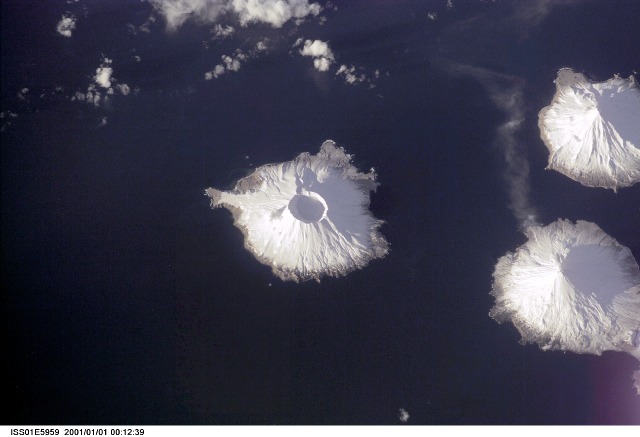
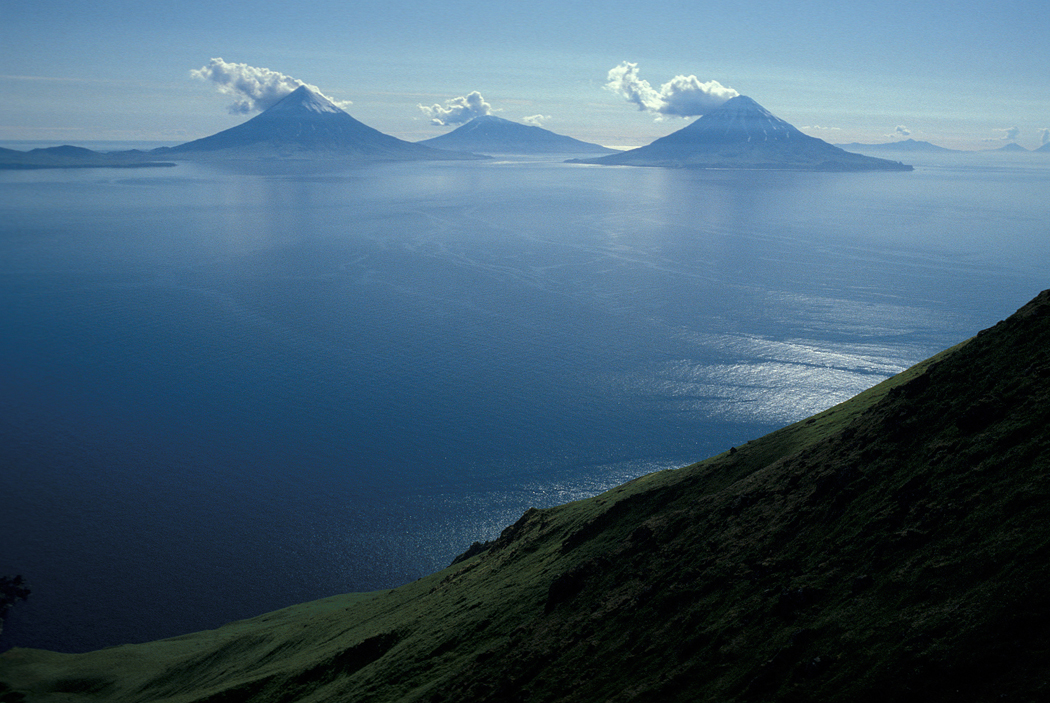
Islands of Four Mountains Herbert Island in der Bildmitte, Carlisle Island rechts oben, der aktive Vulkan Mount Cleveland auf Chuginadak rechts unten.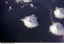
Gewässer Pazifischer Ozean Archipel Aleuten Geographische Lage 52° 52′ N, 169° 48′ W52.866667-169.8Koordinaten: 52° 52′ N, 169° 48′ W 

Anzahl der Inseln 7 Hauptinsel Yunaska Island Gesamtfläche 545,596 km² Einwohner (unbewohnt) Islands of Four Mountains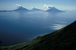
Die Islands of Four Mountains sind eine Inselgruppe in den Alëuten zwischen den Andreanof Islands im Westen und den Fox Islands im Osten. Die zu Alaska (USA) gehörende Inselgruppe erstreckt sich in Ost-West-Richtung über 80 km und wird von den Meeresstraßen Amukta Pass und Samalga Pass im Westen und Osten begrenzt.
Inhaltsverzeichnis
Geographie
In der Inselkette liegen von West nach Ost:
- Amukta Island
- Chagulak Island
- Yunaska Island
- Herbert Island
- Carlisle Island
- Chuginadak Island
- Uliaga Island
- Kagamil Island
Die zwei größten Inseln sind Yunaska und Chuginadak.
Die Inseln haben eine Fläche von 545,596 km² und sind nicht ganzjährig bewohnt.[1]
Geschichte
Die Aleuten, die diese Inseln schon seit 5000 Jahren bewohnten, nannten sie „Unigun“ (deutsch: „Geburtsort der Winde“), denn heulende Stürme sind hier keine Seltenheit. Die Aleuten betrachteten diese Inseln, besonders Kagamil Island, als den Ursprungsort ihres Volkes. Sie begruben ihre Toten hier, mumifiziert, was auf die spirituelle Bedeutung dieses Ortes hinweist.
Wegen der vier bedeutenden Vulkane Mount Cleveland, Mount Carlisle, Mount Kagamil und Mount Herbert tauften die russischen Forscher diese Inseln „Inseln der vier Hügel“ (russisch четырехсопочные острова, tschetyrjechsopotschnye ostrowa).
Der heutige Name wurde 1894 auf der USS Concord kreiert und 1895 durch die U.S. Navy Hydrography Office (Chart 8) publiziert.[2]
Fauna
Auf den Islands of Four Mountains brüten unter anderem Bartalken, nach dem Zwergalk der kleinste der Alkenvögel.[3]
Quellen
- ↑ Islands of Four Mountains: Blocks 1080 thru 1082, Census Tract 1, Aleutians West Census Area, Alaska United States Census Bureau, 2000
- ↑ Islands of Four Mountains im Geographic Names Information System des United States Geological Survey
- ↑ Anthony J. Gaston und Ian L. Jones: The Auks. Oxford University Press, Oxford 1998, ISBN 0-19-854032-9, S. 263
Weblinks
Inselgruppen der AleutenAndreanof Islands | Fox Islands | Krenitzin Islands | Near Islands | Islands of Four Mountains | Rat Islands
Wikimedia Foundation.
Schlagen Sie auch in anderen Wörterbüchern nach:
Islands of Four Mountains — Islands of Four Mountainscoord|52.876|N|169.795|W|display=title is an island grouping of the Aleutian Islands in Alaska, United States. The chain includes, from west to east, Amukta, Chagulak, Yunaska, Herbert, Carlisle, Chuginadak, Uliaga, and… … Wikipedia
Islands of Four Mountains — Sp Keturių Kalnų sãlos Ap Islands of Four Mountains L Aleutų ss. grupė, JAV (Aliaska) … Pasaulio vietovardžiai. Internetinė duomenų bazė
Andreanof Islands — Karte der Andreanof Islands Gewässer Pazifischer Ozean Archipel … Deutsch Wikipedia
Fox Islands (Alaska) — Fox Islands Karte der Fox Islands Gewässer Nordpazifik Archipel … Deutsch Wikipedia
Aleutian Islands — Infobox Islands name = Aleutian Islands image caption = image size = locator map custom = no native name = native name link = nickname = location = Pacific Ocean coordinates = archipelago = total islands = >300 major islands = Unalaska Island… … Wikipedia
Andreanof Islands — The Andreanof Islands (Niiĝuĝin tanangis [Bergsland, K Aleut Dictionary Fairbanks: Alaska Native Language Center, 1994] in Aleut) are a group of islands in the Aleutian Islands in southwest Alaska. They are located between Amchitka Pass and the… … Wikipedia
List of islands of Alaska — This is an incomplete list of islands in the U.S. state of Alaska. There are about 2,670 named islands in the state.Cref|A [Cite web title=Alaska Office of Economic Development publisher=Alaska Department of Commerce, Community and Economic… … Wikipedia
Near Islands — Karte der Near Islands Gewässer Nordpazifik Archipel … Deutsch Wikipedia
List of Aleutian Islands — Major groups in the Aleutian Islands are listed from east to west, and islands within each group are listed alphabetically. The Aleut names are given in brackets. =Fox Islands= *Aiktak Island (Ugangax) *Akun Island (Akungan) *Akutan Island… … Wikipedia
Krenitzin Islands — Gewässer Pazifischer Ozean Archipel Aleuten Geographische Lage … Deutsch Wikipedia
- Kontaktieren Sie uns: Unterstützung, Werbung
Islands of Four Mountains
18+
© Academic, 2000-2024
Wörterbücher Export, schritte mit PHP, Joomla, Drupal, WordPress, MODx.