- Irthing
-
Irthing 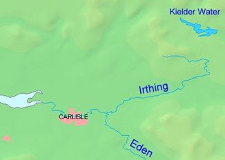
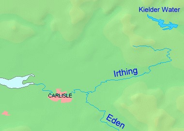
Verlauf des Flusses Irthing
Daten Lage nördliches England Flusssystem Eden Abfluss über Eden → Solway Firth Ursprung Zusammenfluss von Tarn Beck und Gair Burn am Irthing Head in den Cheviot Hills
55° 5′ 57″ N, 2° 35′ 0″ W55.099063-2.583271Mündung östlich Carlisle in den Eden 54.913739-2.829165Koordinaten: 54° 54′ 49″ N, 2° 49′ 45″ W
54° 54′ 49″ N, 2° 49′ 45″ W54.913739-2.829165Länge 55 km Der Irthing ist ein Fluss in Nordengland nahe der schottischen Grenze. Er entspringt nahe dem Berg Black Knowe in den Cheviot Hills (ca. 490 m ASL). Er mündet in der Nähe der Stadt Carlisle in den Fluss Eden. Seine Länge beträgt 55 km. Nach etwa 1/3 seiner Länge durchquert er bei Gilsland den früheren römischen Hadrianswall.
Der Irthing ist ein flacher Fluss, der nach Regenfällen leicht über die Ufer tritt. Der erste Flussabschnitt bildet quasi die südwestliche Grenze des Northumberland-Nationalparks. Im Irthing findet man Lachse und Forellen. Der Ort Irthington wurde nach dem Fluss benannt.
Kategorien:- Flusssystem Eden
- Fluss in Europa
- Fluss in England
- Cumbria
Wikimedia Foundation.