Inverell Shire

Inverell Shire
Shire of Inverell
Australia-Map-NSW-LGA-Inverell.png
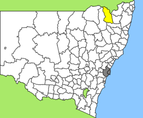
Lage des Inverell Shire in New South Wales
Gliederung
Staat: Australien Australien
Bundesstaat: Flag of New South Wales.svg New South Wales
Verwaltungssitz: Inverell
Daten und Zahlen
Fläche: 8.606 km²
Einwohner: 15.510 (2006) [1]
Bevölkerungsdichte: 1,8 Einwohner je km²
-29.766666666667151.11666666667

Inverell Shire ist ein lokales Verwaltungsgebiet (LGA) im australischen Bundesstaat New South Wales. Das Gebiet ist 8.606 km² groß und hat etwa 16.000 Einwohner.

Inverell liegt im Nordosten des Staates an der Grenze zu Queensland etwa 630 km nördlich der Metropole Sydney und 430 km südwestlich von Brisbane. Das Gebiet umfasst 83 Ortsteile und Ortschaften, darunter Ashford, Bonshaw, Bukkula, Delungra, Elsmore, Gilgai, Gum Flat, Inverell, Kings Plains, Mount Russell, Nullamanna, Oakwood, Sapphire, Stannifer, Wallangra und Yetman. Der Sitz des Shire Councils befindet sich in Inverell im Süden der LGA, wo etwa 9.800 Einwohner leben.

Inhaltsverzeichnis

Verwaltung

Der Inverell Shire Council hat zwölf Mitglieder, die von den Bewohnern der LGA gewählt werden. Inverell ist nicht in Bezirke untergliedert. Aus dem Kreis der Councillor rekrutiert sich auch der Mayor (Bürgermeister) des Councils.

Töchter und Söhne des Shires

Weblinks

Einzelnachweise

  1. Australian Bureau of Statistics (25. Oktober 2007): Inverell (A) (Local Government Area) (Englisch). 2006 Census QuickStats. Abgerufen am 6. April 2010.

Wikimedia Foundation.

Игры ⚽ Нужна курсовая?

Schlagen Sie auch in anderen Wörterbüchern nach:

  • Inverell Shire Council — Infobox Australian Place | type = lga name = Inverell Shire caption = Location in New South Wales state=New South Wales region=North West Slopes area=8606 est = seat=Inverell (144 Otho Street)cite web title=Inverell Shire Council publisher =… …   Wikipedia

  • Inverell — Gerichtsgebäude, 1886 erbaut Staat …   Deutsch Wikipedia

  • Inverell, New South Wales — Infobox Australian Place | type = town name = Inverell state = nsw caption = Inverell Court House built in 1886. lga = Inverell Shire Council county = Gough postcode = 2360 est = 1856 pop = 9,749 elevation= 583 maxtemp = 24.0 mintemp = 7.4… …   Wikipedia

  • Inverell — ▪ New South Wales, Australia       town, northeastern New South Wales, Australia, at the junction of the Swanbrook and Macintyre rivers in the Western Slopes district. Established in 1848 as a stock station, it was declared a town in 1858 and a… …   Universalium

  • Shire of Inglewood — Infobox Australian Place | type = lga name = Shire of Inglewood state = qld imagesize= 135 caption = Location within Queensland pop = 2,610 (2001 census) area = est = seat = Inglewood region = logosize = 143 url = http://www.inglewood.qld.gov.au/ …   Wikipedia

  • Shire of Waggamba — Infobox Australian Place | type = lga name = Shire of Waggamba state = qld imagesize= 180 caption = Location within Queensland pop = 2,963 area = 13500 est = seat = Goondiwindi region = logosize = 140 url = http://www.waggamba.qld.gov.au/ near nw …   Wikipedia

  • Wakool Shire — Shire of Wakool New South Wales Location in New South Wales Population: 4,427(2009) …   Wikipedia

  • Muswellbrook Shire — New South Wales Location in New South Wales Population …   Wikipedia

  • Conargo Shire — New South Wales Location in New South Wales Population: 1,700(2009) …   Wikipedia

  • Murray Shire — This article is about the Murray Shire in New South Wales. For the Western Australia shire, see Shire of Murray. Murray Shire New South Wales …   Wikipedia

Share the article and excerpts

Direct link
Do a right-click on the link above
and select “Copy Link”