- Fredonia (Arizona)
-
Fredonia 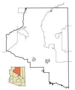 Lage im Coconino County und in Arizona
Basisdaten Staat: Vereinigte Staaten Bundesstaat: Arizona County: Koordinaten: 36° 57′ N, 112° 32′ W36.945555555556-112.525555555561424Koordinaten: 36° 57′ N, 112° 32′ W Zeitzone: Mountain Standard Time (UTC−7) Einwohner: 1051 (Stand: 2000) Bevölkerungsdichte: 54,7 Einwohner je km² Fläche: 19,2 km² (ca. 7 mi²)
davon 19,2 km² (ca. 7 mi²) LandHöhe: 1424 m Postleitzahlen: 86022, 86052 Vorwahl: +1 928 FIPS: 04-25720 GNIS-ID: 0004835 Fredonia ist eine Stadt im Coconino County im Nordwesten des US-Bundesstaates Arizona, dem so genannten Arizona Strip. Im Jahr 2000 hatte sie 1036 Einwohner und eine Fläche von 19,2 km². Die Bevölkerungsdichte liegt bei 54,0/km². Fredonia liegt am Knotenpunkt der Arizona State Route 389 mit dem U.S. Highway 89A und am Kanab Creek, einem Nebenfluss des Colorado Rivers.
 Orte im Coconino County
Bitter Springs | Cameron | Flagstaff | Fredonia | Grand Canyon Village | Kachina Village | Kaibito | Lechee | Leupp | Moenkopi | Mountainaire | Munds Park | Page | Parks | Sedona | Supai | Tonalea | Tuba City | Tusayan | Valle | Williams
Wikimedia Foundation.
Schlagen Sie auch in anderen Wörterbüchern nach:
Fredonia (Arizona) — Fredonia Pueblo de los Estados Unidos … Wikipedia Español
Fredonia, Arizona — Infobox Settlement official name = Fredonia, Arizona settlement type = Town imagesize = image caption = image imagesize = image caption = image mapsize = 250x250px map caption = Location in Coconino County and the state of Arizona mapsize1 = map… … Wikipedia
Fredonia — is the name of some places in the United States of America:*Fredonia, Arizona *Fredonia (Biscoe), Arkansas *Fredonia, Iowa *Fredonia, Kansas *Fredonia, Kentucky *Fredonia, New York *Fredonia, North Dakota *Fredonia, Pennsylvania *Fredonia,… … Wikipedia
Fredonia — ist die Bezeichnung mehrerer Orte in den Vereinigten Staaten: Fredonia (Alabama) Fredonia (Arizona) Fredonia (Arkansas) Fredonia (Iowa) Fredonia (Kansas) Fredonia (Kentucky) Fredonia (New York) Fredonia (North Dakota) Fredonia (Pennsylvania)… … Deutsch Wikipedia
Fredonia-Moccasin Unified School District — is a school district headquartered in Fredonia, Arizona, United States.The schools operated by the district include Fredonia Elementary/Middle School and Fredonia High School; both are in Fredonia. The district serves Fredonia and unincorporated… … Wikipedia
Arizona locations by per capita income — Arizona has the twenty ninth highest per capita income in the United States of America, at $20,275 (2000). Its personal per capita income is $26,838 (2003). Arizona counties ranked by per capita income There are fifteen counties located in… … Wikipedia
Arizona Strip — The Arizona Strip is the part of the U.S. state of Arizona lying north of the Colorado River. The difficulty of crossing the Grand Canyon causes this region to have more natural connections with southern Utah and Nevada than with the rest of… … Wikipedia
Fredonia — Cette page d’homonymie répertorie les différentes localités partageant un même nom. Fredonia peut désigner : Colombie Fredonia (Colombie) … Wikipédia en Français
Fredonia — Fredonia, AZ U.S. town in Arizona Population (2000): 1036 Housing Units (2000): 455 Land area (2000): 7.414772 sq. miles (19.204170 sq. km) Water area (2000): 0.000000 sq. miles (0.000000 sq. km) Total area (2000): 7.414772 sq. miles (19.204170… … StarDict's U.S. Gazetteer Places
Fredonia, AZ — U.S. town in Arizona Population (2000): 1036 Housing Units (2000): 455 Land area (2000): 7.414772 sq. miles (19.204170 sq. km) Water area (2000): 0.000000 sq. miles (0.000000 sq. km) Total area (2000): 7.414772 sq. miles (19.204170 sq. km) FIPS… … StarDict's U.S. Gazetteer Places
Fredonia (Arizona)


18+
© Academic, 2000-2024
- Kontaktieren Sie uns: Unterstützung, Werbung
Wörterbücher Export, schritte mit PHP, Joomla, Drupal, WordPress, MODx.