- Zámutov
-
Zámutov
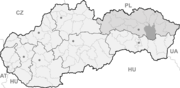
Wappen Karte 

Zámutov BasisdatenKraj: Prešovský kraj Okres: Vranov nad Topľou Region: Horný Zemplín Fläche: 41,434 km² Einwohner: 2.996 (31. Dez. 2010) Bevölkerungsdichte: 72,31 Einwohner je km² Höhe: 274 m n.m. Postleitzahl: 094 15 Telefonvorwahl: 0 57 Geographische Lage: 48° 54′ N, 21° 34′ O48.90277777777821.561111111111274Koordinaten: 48° 54′ 10″ N, 21° 33′ 40″ O Kfz-Kennzeichen: VT Gemeindekennziffer: 529265 StrukturGemeindeart: Gemeinde Verwaltung (Stand: April 2011)Bürgermeister: Dušan Višňovský Adresse: Obecný úrad Zámutov
434
094 15 ZámutovWebpräsenz: www.zamutov.sk Gemeindeinformation
auf portal.gov.skStatistikinformation
auf statistics.skZámutov (ungarisch Opálhegy - bis 1907 Zamutó) ist eine Gemeinde im Okres Vranov nad Topľou des Prešovský kraj im Osten der Slowakei. Die Zahl der Einwohner betrug am 31. Dezember 2010 2.996 Personen.
Geographie
Die Gemeinde liegt in den östlichen Ausläufern der Slanské vrchy am Bach Zámutovský potok und liegt 11 Kilometer westlich der Stadt Vranov nad Topľou. Verkehrsmäßig ist der Ort über eine Kreisstraße vom Nachbarort Čaklov, der an der Hauptstraße 18 liegt, zu erreichen.
Geschichte
Der Ort wurde im frühen 14. Jahrhundert von einem Schultheiß gegründet und ist zum ersten Mal 1402 als Zamuth schriftlich erwähnt. Er gehörte zum Herrschaftsgut der Burg Čičava. Nach dem Aussterben der Familie Rozgony im Jahr 1523, der die Burg gehörte, kam der Ort zur Familie Báthory und wechselte seit dem 17. Jahrhundert weiter seine Besitzer, wie Barkoczy, Almássy und Szirmay.
Die Bevölkerung beschäftigte sich mit Land-, Forstwirtschaft und Köhlerei. Daneben gab es auch zwei kleine Mühlen sowie eine Schnapsbrennerei und es wurden zeitweise auf dem Gemeindegebiet Braunkohle, Eisenerz und Opale abgebaut. An die Opalförderung erinnert noch der ab 1907 verwendete ungarische Name (Opálhegy heißt wörtlich „Opal-Berg“).
Zámutov wird außerdem mit dem sog. Ostslowakischen Bauernaufstand von 1831 verbunden, da der Ort eines der Zentren der Aufständischen war.
Bis 1918 lag der Ort im Komitat Semplin im Königreich Ungarn und kam danach zur Tschechoslowakei, bzw. heute Slowakei.
Sehenswürdigkeiten
- römisch-katholische Kirche der Maria Rosenkranzkönigin (Ružencová Panna Mária) aus dem Jahr 1912
- evangelische Kirche aus dem Jahr 1920
- griechisch-katholische Kirche, die ursprünglich 1974 als ein Gebetshaus entstand und 1990 zur Kirche umgebaut
Gemeinden im Okres Vranov nad TopľouBabie | Banské | Benkovce | Bystré | Cabov | Čaklov | Čičava | Čierne nad Topľou | Davidov | Detrík | Dlhé Klčovo | Ďapalovce | Ďurďoš | Giglovce | Girovce | Hanušovce nad Topľou | Hencovce | Hermanovce nad Topľou (Hermannsdorf) | Hlinné | Holčíkovce | Jasenovce | Jastrabie nad Topľou | Juskova Voľa | Kamenná Poruba | Kladzany | Komárany | Kučín | Kvakovce | Majerovce | Malá Domaša | Matiaška | Medzianky | Merník | Michalok (Michalok) | Nižný Hrabovec | Nižný Hrušov | Nižný Kručov | Nová Kelča | Ondavské Matiašovce | Pavlovce | Petkovce | Petrovce | Piskorovce | Poša | Prosačov | Radvanovce | Rafajovce | Remeniny | Rudlov | Ruská Voľa | Sačurov | Sečovská Polianka | Sedliská | Skrabské | Slovenská Kajňa | Soľ | Štefanovce | Tovarné | Tovarnianska Polianka | Vavrinec | Vechec | Vlača | Vranov nad Topľou (Frönel an der Töpl) | Vyšný Kazimír | Vyšný Žipov | Zámutov | Zlatník | Žalobín
Wikimedia Foundation.
Schlagen Sie auch in anderen Wörterbüchern nach:
Zámutov — (Village) Administration Pays Slovaquie … Wikipédia en Français
Zámutov — is a village and municipality in Vranov nad Topľou District in the Prešov Region of eastern Slovakia.HistoryIn historical records the village was first mentioned in 1402.GeographyThe municipality lies at an elevation of 250 metres and covers an… … Wikipedia
Prešov Region — Geobox | Region name = Prešov category = Region image caption = image caption = symbol = symbol type = etymology = official name = motto = nickname = country = Slovakia country state = region = district = commune = municipality = border = part… … Wikipedia
Vranov nad Topľou District — Infobox Slovak district subject name = Vranov nad Topľou District region district slovak region = Prešov Region population = 76,504 (2001) prefix = ? area = 769 car plate = VT image location = Okres vranov.png Vranov nad Topľou District ( okres… … Wikipedia
Nižný Hrabovec — Location of Vranov nad Topľou District in the Nižný Hrabovec (Hungarian: Alsógyertyán; earlier i.a.: Slovak Nižssí Hrabowec/Hungarian Alsóhrabóc) is a village and municipality in the Vranov nad Topľou District in the Prešov Region of Slovakia … Wikipedia
List of municipalities and towns in Slovakia — Slovakia This is a comprehensive list of municipalities and towns in Slovakia. For lists of towns and municipalities sorted by Regions see the individual articles on Regions. For an outdated list of towns only in Slovakia see also List of towns… … Wikipedia
Davidov (municipality) — Location of Vranov nad Topľou District Davidov is a village and municipality in the Vranov nad Topľou District in the Prešov Region of Slovakia … Wikipedia
Čičava — Location of Vranov nad Topľou District in the Prešov Region. Čičava is a village and municipality in Vranov nad Topľou District in the Prešov Region of eastern Slovakia. History In historical records t … Wikipedia
Čierne nad Topľou — Location of Vranov nad Topľou District in the Prešov Region. Čierne nad Topľou is a village and municipality in Vranov nad Topľou District in the Prešov Region of eastern Slovakia. History In historical re … Wikipedia
Detrík — Location of Vranov nad Topľou District in the Prešov Region. Detrík is a village and municipality in Vranov nad Topľou District in the Prešov Region of eastern Slovakia. History In historical records t … Wikipedia
Zámutov


18+
© Academic, 2000-2024
- Kontaktieren Sie uns: Unterstützung, Werbung
Wörterbücher Export, schritte mit PHP, Joomla, Drupal, WordPress, MODx.