- Skrabské
-
Skrabské
Wappen Karte 
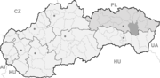

Skrabské BasisdatenKraj: Prešovský kraj Okres: Vranov nad Topľou Region: Šariš Fläche: 11,04 km² Einwohner: 778 (31. Dez. 2010) Bevölkerungsdichte: 70,47 Einwohner je km² Höhe: 159 m n.m. Postleitzahl: 094 33 Telefonvorwahl: 0 57 Geographische Lage: 49° 0′ N, 21° 35′ O49.00722222222221.577777777778159Koordinaten: 49° 0′ 26″ N, 21° 34′ 40″ O Kfz-Kennzeichen: VT Gemeindekennziffer: 529150 StrukturGemeindeart: Gemeinde Verwaltung (Stand: November 2010)Bürgermeister: Štefan Hudák Adresse: Obecný úrad Skrabské č. 78
09433 SkrabskéWebpräsenz: www.skrabske.ocu.sk Gemeindeinformation
auf portal.gov.skStatistikinformation
auf statistics.skSkrabské (bis 1927 slowakisch auch „Strabské“; ungarisch Tapolymogyorós - bis 1902 Mogyoróska) ist eine Gemeinde im Bezirk Vranov nad Topľou in der Slowakei und liegt auf einer Höhe von 159 Metern über dem Meeresspiegel im Prešovský kraj der Ostslowakei.
Haupteinnahmequelle des Dorfes sind Land- und Forstwirtschaft. Die früheste schriftliche Erwähnung von Skrabské stammt aus dem Jahr 1321.
Gemeinden im Okres Vranov nad TopľouBabie | Banské | Benkovce | Bystré | Cabov | Čaklov | Čičava | Čierne nad Topľou | Davidov | Detrík | Dlhé Klčovo | Ďapalovce | Ďurďoš | Giglovce | Girovce | Hanušovce nad Topľou | Hencovce | Hermanovce nad Topľou (Hermannsdorf) | Hlinné | Holčíkovce | Jasenovce | Jastrabie nad Topľou | Juskova Voľa | Kamenná Poruba | Kladzany | Komárany | Kučín | Kvakovce | Majerovce | Malá Domaša | Matiaška | Medzianky | Merník | Michalok (Michalok) | Nižný Hrabovec | Nižný Hrušov | Nižný Kručov | Nová Kelča | Ondavské Matiašovce | Pavlovce | Petkovce | Petrovce | Piskorovce | Poša | Prosačov | Radvanovce | Rafajovce | Remeniny | Rudlov | Ruská Voľa | Sačurov | Sečovská Polianka | Sedliská | Skrabské | Slovenská Kajňa | Soľ | Štefanovce | Tovarné | Tovarnianska Polianka | Vavrinec | Vechec | Vlača | Vranov nad Topľou (Frönel an der Töpl) | Vyšný Kazimír | Vyšný Žipov | Zámutov | Zlatník | Žalobín
Wikimedia Foundation.
Schlagen Sie auch in anderen Wörterbüchern nach:
Skrabské — (Village) Administration Pays Slovaquie … Wikipédia en Français
Skrabské — is a village and municipality in Vranov nad Topľou District in the Prešov Region of eastern Slovakia.HistoryIn historical records the village was first mentioned in 1321.GeographyThe municipality lies at an altitude of 159 metres and covers an… … Wikipedia
Bystré (Slowakei) — Bystré Wappen Karte … Deutsch Wikipedia
Prešov Region — Geobox | Region name = Prešov category = Region image caption = image caption = symbol = symbol type = etymology = official name = motto = nickname = country = Slovakia country state = region = district = commune = municipality = border = part… … Wikipedia
Vranov nad Topľou District — Infobox Slovak district subject name = Vranov nad Topľou District region district slovak region = Prešov Region population = 76,504 (2001) prefix = ? area = 769 car plate = VT image location = Okres vranov.png Vranov nad Topľou District ( okres… … Wikipedia
Nižný Hrabovec — Location of Vranov nad Topľou District in the Nižný Hrabovec (Hungarian: Alsógyertyán; earlier i.a.: Slovak Nižssí Hrabowec/Hungarian Alsóhrabóc) is a village and municipality in the Vranov nad Topľou District in the Prešov Region of Slovakia … Wikipedia
List of municipalities and towns in Slovakia — Slovakia This is a comprehensive list of municipalities and towns in Slovakia. For lists of towns and municipalities sorted by Regions see the individual articles on Regions. For an outdated list of towns only in Slovakia see also List of towns… … Wikipedia
Davidov (municipality) — Location of Vranov nad Topľou District Davidov is a village and municipality in the Vranov nad Topľou District in the Prešov Region of Slovakia … Wikipedia
Čičava — Location of Vranov nad Topľou District in the Prešov Region. Čičava is a village and municipality in Vranov nad Topľou District in the Prešov Region of eastern Slovakia. History In historical records t … Wikipedia
Čierne nad Topľou — Location of Vranov nad Topľou District in the Prešov Region. Čierne nad Topľou is a village and municipality in Vranov nad Topľou District in the Prešov Region of eastern Slovakia. History In historical re … Wikipedia
Skrabské

18+
© Academic, 2000-2024
- Kontaktieren Sie uns: Unterstützung, Werbung
Wörterbücher Export, schritte mit PHP, Joomla, Drupal, WordPress, MODx.