- Tuczępy
-
Tuczępy 

Tuczępy Basisdaten Staat: Polen Woiwodschaft: Heiligkreuz Landkreis: Busko-Zdrój Geographische Lage: 50° 31′ N, 21° 0′ O50.51666666666720.992777777778Koordinaten: 50° 31′ 0″ N, 20° 59′ 34″ O Einwohner: -
(31. Dez. 2010)[1]Postleitzahl: 28-142 Telefonvorwahl: (+48) 41 Kfz-Kennzeichen: TBU Wirtschaft und Verkehr Straße: DW 756 Rzepin - Stopnica, DW 757 Opatów – Stopnica Nächster int. Flughafen: Krakau-Balice Gemeinde Gemeindeart: Landgemeinde Fläche: 83,7 km² Einwohner: 3842
(31. Dez. 2010) [2]Bevölkerungsdichte: 46 Einw./km² Gemeindenummer (GUS): 2601072 Verwaltung (Stand: 2011) Bürgermeister: mgr Marek Kaczmarek Adresse: Tuczępy 35
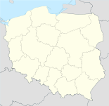
28-142 TuczępyWebpräsenz: www.tuczepy.pl/ Tuczępy [tuˈt͡ʃɛmpɨ] ist eine Landgemeinde und deren Hauptort in Polen in der Wojewodschaft Heiligkreuz etwa 49 km südöstlich von Kielce und 21 km östlich der Kreisstadt Busko-Zdrój. Die Einwohnerzahl beträgt rund 4000.
Inhaltsverzeichnis
Geschichte
Der Ort wird erstmals im 12. Jahrhundert genannt. Bei der Tatareninvasion wurde der Ort zerstört und während der Schwedischen Sintflut wurde er geplündert. In der Ortschaft Nieciesławice ließ sich im 18. Jahrhundert die Familie Kołłątaj nieder und der Aufklärer Hugo Kołłątaj verbrachte hier seine Jugend.
1795 fiel Tuczępy mit der Dritten Polnischen Teilung an Österreich. 1809 kam es an das Herzogtum Warschau und 1815 an das Königreich Polen. Nach Ende des Ersten Weltkriegs kam der Ort wieder zum neu entstandenen Polen.
Gemeinde
Zu Tuczępy gehören die Ortsteile Brzozówka, Chałupki, Dobrów, Góra, Grzymała, Januszkowice, Jarosławice, Kargów, Nieciesławice, Niziny, Podlesie, Rzędów, Sachalin, Sieczków und Wierzbica. Der Anteil der Ackerflächen beträgt rund 60%, der Waldanteil rund 30%. Die Gemeinde hat landwirtschaftlich-industriellen Charakter.
Sehenswürdigkeiten
- Die einschiffige Barockkirche Johannes des Täufers (Jana Chrzciciela) aus den Jahren 1666 bis 1674 in Tuczępy.
- Der frühere Gutshof aus der Zeit um 1930, jetzt Sitz der Gemeindeverwaltung.
Literatur
- Ziemia Buska, Swiatowid, Kielce 2009, ISBN 978-83-925632-9-7, S. 120-125.
Fußnoten
- ↑ Population. Size and Structure by Territorial Division. As of December 31, 2010. Główny Urząd Statystyczny (GUS), abgerufen am 30. Juni 2011.
- ↑ Population. Size and Structure by Territorial Division. As of December 31, 2010. Główny Urząd Statystyczny (GUS), abgerufen am 30. Juni 2011.
Kategorien:- Gmina in der Woiwodschaft Heiligkreuz
- Ort der Woiwodschaft Heiligkreuz


Wikimedia Foundation.