- Staszów
-
Staszów 
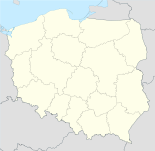

Staszów Basisdaten Staat: Polen Woiwodschaft: Heiligkreuz Landkreis: Staszów Geographische Lage: 50° 34′ N, 21° 10′ O50.56416666666721.166944444444Koordinaten: 50° 33′ 51″ N, 21° 10′ 1″ O Einwohner: 15.108
(31. Dez. 2010)[1]Postleitzahl: 28-200 Telefonvorwahl: (+48) 41 Kfz-Kennzeichen: TSZ Wirtschaft und Verkehr Straße: DW 765 Chmielnik – Osiek, DW 757 Opatów – Stopnica, DW 764 Kielce - Polaniec Nächster int. Flughafen: Krakau-Balice Gemeinde Gemeindeart: Stadt- und Landgemeinde Fläche: 225,9 km² Einwohner: 26.077
(31. Dez. 2010) [2]Bevölkerungsdichte: 115 Einw./km² Gemeindenummer (GUS): 2612073 Verwaltung (Stand: 2011) Bürgermeister: Romuald Garczewski Adresse: ul. Opatowska 31
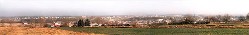
28-200 StaszówWebpräsenz: www.staszow.pl/ Das an der Czarna Staszowska gelegene Staszów ist als Stadt- und Landgemeinde (gmina) und deren Hauptort eine Kreisstadt in Polen in der Wojewodschaft Heiligkreuz etwa 53 km südöstlich von Kielce. Die Gemeinde hatte im Jahr 2006 26492 Einwohner, ihr Hauptort 15499 Einwohner, die Landgemeinde 10993 Einwohner. In Staszów kreuzen sich drei Eisenbahnlinien, darunter die Breitspurbahn Linia Hutnicza Szerokotorowa.
Inhaltsverzeichnis
Geschichte
Der Ort wird 1241 erstmals genannt. Die dem Heiligen Bartholomäus geweihte Backsteinkirche wurde 1345 fertiggestellt. 1525 erhielt Staszów das Privileg, dreimal im Jahr einen Jahrmarkt abzuhalten. Um 1580 traten die Polnischen Brüder auf. 1718 wurde die Synagoge errichtet. 1731 kam der Ort unter die Herrschaft der Czartoryski.
1795 fiel Staszów mit der Dritten Polnischen Teilung an Österreich. 1809 kam die Stadt an das Herzogtum Warschau. 1815 fiel der Ort an das Königreich Polen. Nach Ende des Ersten Weltkriegs kam der Ort wieder zum neu entstandenen Polen. Die jüdische Gemeinde, die 1930 55% der Bevölkerung ausmachte, fiel dem Holocaust zum Opfer; die Ermordung einer Vielzahl jüdischer Bewohner am als „Schwarzer Sonntag“ bezeichneten 8. November 1942 beschreibt der Sefer Staszów. 1944 wurde der Ort durch Bombardements zu 80% zerstört. 1954 wurde Staszów wieder Kreisstadt.
Gemeinde
 Zur Gmina Staszów gehören die Ortsteile Czajków Północny, Czajków Południowy, Czernica, Dobra, Gaj Koniemłocki, Grzybów, Jasień, Koniemłoty, Kopanina, Krzczonowice, Krzywołęcz, Kurozwęki, Łaziska, Lenartowice, Łukawica, Mostki, Niemścice, Oględów, Poddębowiec, Podmaleniec, Ponik, Sielec, Smerdyna, Stefanówek, Sztombergi, Wiązownica Duża, Wiązownica Mała, Wiązownica-Kolonia, Wiśniowa, Wiśniowa Poduchowna, Wola Osowa, Wola Wiśniowska, Wólka Żabna, Zagrody und Ziemblice.
Sehenswürdigkeiten
 Die St.-Bartholomäus-Kirche
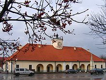 Rathaus auf dem Marktplatz
- Die St.-Bartholomäus-Kirche.
- Steinhäuser am Marktplatz (Rynek) und Rathaus.
Weblinks
 Commons: Staszów – Album mit Bildern und/oder Videos und Audiodateien
Fußnoten
- ↑ Population. Size and Structure by Territorial Division. As of December 31, 2010. Główny Urząd Statystyczny (GUS), abgerufen am 30. Juni 2011.
- ↑ Population. Size and Structure by Territorial Division. As of December 31, 2010. Główny Urząd Statystyczny (GUS), abgerufen am 30. Juni 2011.
Kategorien:- Gmina in der Woiwodschaft Heiligkreuz
- Ort der Woiwodschaft Heiligkreuz


Wikimedia Foundation.