- Seixezelo
-
Seixezelo Wappen Karte 
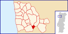
Basisdaten Region: Norte Unterregion: Grande Porto Distrikt: Porto Concelho: Vila Nova de Gaia Koordinaten: 41° 2′ N, 8° 33′ W41.032666-8.550997Koordinaten: 41° 2′ N, 8° 33′ W Einwohner: 1.729 (Stand: 2001) Fläche: 1,9 km² Bevölkerungsdichte: 910 Einwohner pro km² Politik Adresse der Gemeindeverwaltung: Junta de Freguesia de Seixezelo
Rua da Igreja, 634
4415-937 Vila Nova de GaiaWebseite: www.jfseixezelo.pt Seixezelo ist eine Gemeinde im Nordwesten Portugals.
Seixezelo gehört zum Kreis Vila Nova de Gaia im Distrikt Porto, besitzt eine Fläche von 1,9 km² und hat 1.729 Einwohner (Stand: 2001).[1]
Einzelnachweise
- ↑ Daten zu Seixezelo. alea.pt, abgerufen am 11. Juni 2011 (englisch).
Weblinks
- Karte der Freguesia Seixezelo beim Instituto Geográfico do Exército
 Freguesias im Concelho Vila Nova de Gaia
Arcozelo | Avintes | Canelas | Canidelo | Crestuma | Grijó | Gulpilhares | Lever | Madalena | Mafamude | Olival | Oliveira do Douro | Pedroso | Perosinho | Sandim | Santa Marinha | São Félix da Marinha | São Pedro da Afurada | Seixezelo | Sermonde | Serzedo | Valadares | Vilar de Andorinho | Vilar do Paraíso
Wikimedia Foundation.
Schlagen Sie auch in anderen Wörterbüchern nach:
Seixezelo — Freguesia de Portugal … Wikipedia Español
Seixezelo — is a Portuguese parish in the municipality of Vila Nova de Gaia. It has a population of 1,729 and an area of 1.61 km² … Wikipedia
Сейшезелу — Посёлок Сейшезелу Seixezelo Страна ПортугалияПортугалия … Википедия
Районы округа Порту — … Википедия
Vila Nova de Gaia — seen from Porto Vila Nova de Gaia, or simply Gaia (Portuguese pronunciation: [ˈvilɐ ˈnɔvɐ ðɨ ˈɣajɐ]) is a city in Vila Nova de Gaia Municipality, Portugal. It is located in the Porto District, south of the city of Porto on the other side of… … Wikipedia
List of postal codes in Portugal — Aveiro districtMealhada municipality*3050 Antes *3050 Barcouço *3050 Casal Comba *3050 Luso *3050 Mealhada *3050 Pampilhosa *3050 Vacariça *3050 Ventosa do BairroMurtosa municipality*3870 Bunheiro *3870 Monte *3870 Murtosa *3870 TorreiraOliveira… … Wikipedia
Argoncilhe — Infobox Parish pt official name = São Martinho de Argoncilhe image coat of arms = Brasão Vila de Argoncilhe.gif Municipality = Santa Maria da Feira area total = 8,7 population total = 10,102 population density = 997 occasion = St. Marin day =… … Wikipedia
Mafamude — Location of Mafamude in Vila Nova de Gaia. Mafamude is a Portuguese parish (freguesia) in the municipality of Vila Nova de Gaia, in district of Porto. It has a population of 38,940 (2001) and an area of 5.39 km². It is an urban parish in the … Wikipedia
Crestuma — Location of Crestuma in Vila Nova de Gaia. Crestuma is a Portuguese parish in the municipality of Vila Nova de Gaia. It has a population of 2,962 (2001) and an area of 4.93 km² … Wikipedia
Oliveira do Douro, Vila Nova de Gaia — For other uses, see Oliveira do Douro (disambiguation). Location of Oliveira do Douro in Vila Nova de Gaia. Oliveira do Douro is a Portuguese parish in the municipality of Vila Nova de Gaia. It has a population of 23,384 (2001) and an area of… … Wikipedia
Seixezelo


18+
© Academic, 2000-2024
- Kontaktieren Sie uns: Unterstützung, Werbung
Wörterbücher Export, schritte mit PHP, Joomla, Drupal, WordPress, MODx.