- Monte Cetona
-
Monte Cetona 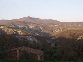
Der Monte Cetona von Süden aus gesehen
Höhe 1.148 m s.l.m. Lage Toskana, Italien Geographische Lage 42° 55′ 49″ N, 11° 52′ 31″ O42.93027777777811.8752777777781148Koordinaten: 42° 55′ 49″ N, 11° 52′ 31″ O 

Der Monte Cetona ist ein Berg in der Toskana in Italien.
Inhaltsverzeichnis
Lage
Er liegt ca. 70 km südöstlich von Siena nahe der Gemeinde Cetona in der Provinz Siena, auf halbem Weg zwischen Florenz und Rom, und stellt mit seinen 1148 m die höchste Erhebung des Chianatals dar. Er ist Teil des Apennin und ist umgeben vom Chianatal und dem Val d’Orcia. Weitere anliegende Gemeinden neben Cetona sind San Casciano dei Bagni, Radicofani und Sarteano. Am südlichen Seitenhang entsteht der Fluss Orcia, der später in den Ombrone mündet.
Archäologie
Erste archäologische Arbeiten fanden 1927 durch Archäologen Umberto Calzoni aus Perugia statt. Dabei wurde die Grotta di San Francesco und die Grotta della Carbonaia entdeckt und freigelegt. 1928 wurden die Antro della Noce, Antro del Poggetto und die Tombetta della Strada, ein miteinander verbundenes Höhlensystem, entdeckt und ausgegraben. Erstmals menschlich besiedelt waren diese Höhlen von den Neandertalern, später dann in der Bronzezeit und in der Jungsteinzeit. Die Ausgrabungen des Calzoni fanden bis 1941 statt. 1984 haben die Universität Siena und die Soprintendenza Archeologica per la Toscana die Forschungen wieder aufgenommen.
Sehenswürdigkeiten
- Grotta di San Francesco, Grotte, in der der hl. Franz von Assisi einen Zeitraum verbracht haben soll.
- Museo Civico per la Preistoria del Monte Cetona, Museum
- Parco Archeologico-Naturalistico del Monte Cetona, Naturpark
Weblinks
 Commons: Cetona – Sammlung von Bildern, Videos und AudiodateienKategorien:
- Eintausender
- Berg in Europa
- Berg in der Toskana


Wikimedia Foundation.