- Klutina River
-
Klutina River 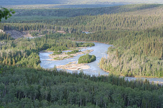
Daten Gewässerkennzahl US: 1404840 Lage Alaska Flusssystem Copper River Abfluss über Copper River → Golf von Alaska Quelle Klutina-Gletscher, Chugach Mountains
61° 23′ 54″ N, 146° 7′ 33″ W61.398333-146.125833Mündung Copper River 61.955278-145.285833Koordinaten: 61° 57′ 19″ N, 145° 17′ 9″ W
61° 57′ 19″ N, 145° 17′ 9″ W61.955278-145.285833Länge 101 km Durchflossene Seen Klutina Lake Der Klutina River ist ein 101 km langer Fluss im Süden von Alaska. Er entspringt aus dem Klutina-Gletscher an der Nordflanke der Chugach Mountains, fließt nordostwärts, durchströmt den Klutina Lake und mündet rund 20 km südöstlich von Glennallen bei Copper Center in den Copper River, der in den Golf von Alaska fließt.
Die Bezeichnung der Ureinwohner Alaskas für den Fluss, „Khlu ti-na“ (Gletscher-Fluss), wurde 1885 von Henry Tureman Allen dokumentiert, der die Schreibweise „Klatena“ verwendete.
Kategorien:- Flusssystem Copper River
- Fluss in Alaska
- Fluss in Nordamerika
- Valdez-Cordova Census Area

Wikimedia Foundation.