Kilchiaran

Kilchiaran
Kilchiaran
Koordinaten 55° 45′ N, 6° 27′ W55.755277777778-6.4538888888889Koordinaten: 55° 45′ N, 6° 27′ W
Kilchiaran (Schottland)
Kilchiaran
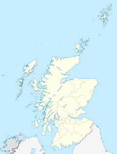
Kilchiaran
Verwaltung
Post town ISLE OF ISLAY
Postleitzahlen­abschnitt PA46
Vorwahl 01496
Landesteil Scotland
Unitary authority Argyll and Bute
Britisches Parlament Argyll and Bute
Schottisches Parlament Argyll and Bute
Gebäude in Kilcharian
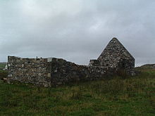
Ruinen der Kapelle von Kilchiaran

Kilchiaran ist ein Weiler an der Westküste der schottischen Hebrideninsel Islay. Die Ortschaft liegt auf der Halbinsel Rhinns of Islay wenige hundert Meter entfernt von einer als Kilchiaran Bay bezeichneten kleinen Bucht[1] des Atlantischen Ozean, in die ein kleiner Bach mündet, der durch die Siedlung verläuft. Port Charlotte und Portnahaven, die bedeutendsten Siedlungen auf der Rhinns of Islay liegen vier Kilometer östlich beziehungsweise acht Kilometer südlich.

Kilchiaran ist über eine einspurige Straße zu erreichen, die von Portnahaven kommend entlang der Westküste nach Kilchiaran führt und von dort aus in östlicher Richtung nach Port Charlotte verläuft.

Einzelnachweise

  1. Eintrag im Gazetteer for Scotland

Wikimedia Foundation.

Игры ⚽ Нужна курсовая?

Schlagen Sie auch in anderen Wörterbüchern nach:

  • RAF Kilchiaran — was an RAF base situated on the Isle of Islay in Scotland.ee also* Islay Airport …   Wikipedia

  • Islay — Infobox Scottish island | coordinates= GridReference=NR370598 celtic name=Ìle norse name=Yula Oy/Il meaning of name= Old Norse for Yula s isle area=61,956 ha area rank=5 highest elevation= Beinn Bheigier 491 m Population=3,457 population rank=7… …   Wikipedia

  • List of RAF stations — This List of RAF stations is a comprehensive list of all stations, airbases, airfields and administrative headquarters of the Royal Air Force past and present.:Note Current RAF Stations will be listed under the currently recognised county of the… …   Wikipedia

  • Islay Airport — Infobox Airport name = Islay Airport nativename = Port adhair Ìle nativename a = nativename r = image width = 200px caption = IATA = ILY ICAO = EGPI type = Public owner = operator = Highlands and Islands Airports Limited city served = Islay… …   Wikipedia

  • BT site engineering code — A BT site engineering code is a group of letters assigned by BT, or its predecessor the General Post Office, to a physical location which is equipped by the company with unusual amounts or types of telecommunications.Such codes relate to both BT… …   Wikipedia

  • Chain Home Low — Radar Coverage 1939 1940 Chain Home Low (CHL) was the name of a British radar early warning system, detecting enemy aircraft movement at lower altitudes than and summarily used with the fixed Chain Home system which was operated by the RAF during …   Wikipedia

  • Islay — (Ìle) Topografische Karte von Islay Gewässer Atlantischer Ozean …   Deutsch Wikipedia

  • Isle of Islay — Topografische Karte von Islay Straßenkarte von Islay …   Deutsch Wikipedia

  • Ìle — Topografische Karte von Islay Straßenkarte von Islay …   Deutsch Wikipedia

  • Айлей (аэропорт) — Координаты: 55°40′55″ с. ш. 6°15′24″ з. д. / 55.681944° с. ш. 6.256667° з. д.  …   Википедия

Share the article and excerpts

Direct link
Do a right-click on the link above
and select “Copy Link”