Carson River Valley — Carson River Valley, WA U.S. Census Designated Place in Washington Population (2000): 2116 Housing Units (2000): 894 Land area (2000): 4.673073 sq. miles (12.103203 sq. km) Water area (2000): 0.024862 sq. miles (0.064392 sq. km) Total area (2000) … StarDict's U.S. Gazetteer Places
Carson River Valley, WA — U.S. Census Designated Place in Washington Population (2000): 2116 Housing Units (2000): 894 Land area (2000): 4.673073 sq. miles (12.103203 sq. km) Water area (2000): 0.024862 sq. miles (0.064392 sq. km) Total area (2000): 4.697935 sq. miles (12 … StarDict's U.S. Gazetteer Places
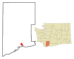
Carson River Valley, Washington — Infobox Settlement official name = Carson River Valley, Washington settlement type = CDP nickname = motto = imagesize = image caption = image imagesize = image caption = image mapsize = 250px map caption = Location of Carson Valley, Washington… … Wikipedia
Carson River — The Carson River, named after explorer Kit Carson, is a river in northern California and northwestern Nevada in the United States, approximately 150 mi (241 km) long. It originates in the Sierra Nevada mountains in California, fed by melted snow … Wikipedia
Carson City, Nevada — Carson City redirects here. For other uses, see Carson City (disambiguation). Carson City Independent city Consolidated Municipality of Carson City … Wikipedia
Carson Robison — Carson Robison, ca. 1930er Jahre Carson Jay Robison (* 4. August 1890 in Oswego, Labette County, Kansas; † 24. März 1957 in Pleasant Valley, New York) war ein US amerikanischer Old Time und Country Musiker. Robison ist auf zahlreichen Aufnahmen… … Deutsch Wikipedia
Carson Sink — is a large playa, approximately 300 sq mi (780 km²) in area, in the Lahontan Valley of northwestern Nevada. It was formerly the terminus of the Carson River, but is currently fed by drainage canals of the Truckee Carson Irrigation District. The… … Wikipedia
Carson Robison — Carson Jay Robison Birth name Carson Jay Robison Also known as Charles Robison Born August 4, 1890(1890 08 04) Origin Oswego, Kansas, USA … Wikipedia
Carson City — a town in and the capital of Nevada, in the W part. 32,022. * * * City (pop., 2000: 52,457), capital of Nevada, U.S. Located east of Lake Tahoe and south of Reno, it was settled in 1858 and later renamed for Kit Carson. The discovery of silver in … Universalium
West Walker River — The West Walker River is a tributary of the Walker River, approximately 75 mi (121 km), in eastern California and western Nevada in the United States. It drains part of the Sierra Nevada range along the California Nevada border in the watershed… … Wikipedia
 Lage im County und im Bundesstaat