- Rhondda Cynon Taf
-
Rhondda Cynon Taf County Borough 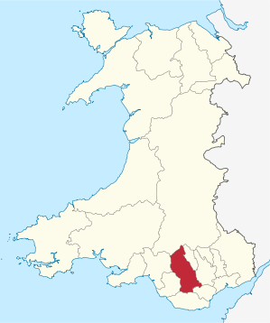
Verwaltungssitz Tonypandy Fläche 424 km² Einwohner 234.400[1] (2009) Walisischsprachige 21,1 % ISO 3166-2 GB-RCT ONS-Code 00PF Website rhondda-cynon-taf.gov.uk Rhondda Cynon Taf ist eine Unitary Authority mit dem Status eines County Borough im Süden von Wales.
Das County Borough grenzt im Osten an Merthyr Tydfil und Caerphilly, im Süden an Cardiff und das Vale of Glamorgan, im Westen an Bridgend und Neath Port Talbot und im Norden an Powys. Die wichtigsten Ortschaften sind Aberdare, Mountain Ash und Pontypridd. Bevölkerungsmäßig steht Rhondda Cynon Taf an zweiter Stelle aller walisischen Verwaltungsbezirke.
Inhaltsverzeichnis
Geschichte
Das County Borough wurde am 1. April 1996 durch einen Zusammenschluss der Districts Cynon Valley, Rhondda und Taff-Ely (ohne die Gemeinden Creigiau und Pentyrch, die zu Cardiff kamen) der damals aufgelösten Verwaltungsgrafschaft Mid Glamorgan gebildet.
Wirtschaft
Die Region ist trotz der Schließung vieler Gruben immer noch das Herzland des walisischen Kohlebergbaus. Zudem ist sie ein Zentrum der britischen Stahlindustrie. Wegen des Niedergangs dieser beiden Haupterwerbszweige versucht die Regionalverwaltung, andere Industrie- und vor allem Dienstleistungsunternehmen anzulocken.
Verwaltung
Das Gebiet wird durch den Rhondda Cynon Taf County Borough Council verwaltet.
Städtepartnerschaften
- seit 1968: Nürtingen, Deutschland
- seit 1993: Ravensburg, Deutschland
Weblinks
Einzelnachweise

Anglesey | Blaenau Gwent | Bridgend | Caerphilly | Cardiff | Carmarthenshire | Ceredigion | Conwy | Denbighshire | Flintshire | Gwynedd | Merthyr Tydfil | Monmouthshire | Neath Port Talbot | Newport | Pembrokeshire | Powys | Rhondda Cynon Taf | Swansea | Torfaen | Vale of Glamorgan | Wrexham
Wikimedia Foundation.
Schlagen Sie auch in anderen Wörterbüchern nach:
Rhondda Cynon Taf — 51° 39′ 00″ N 3° 26′ 24″ W / 51.6501, 3.44003 … Wikipédia en Français
Rhondda Cynon Taf County Borough Council — ( cy. Cyngor Bwrdeistref Sirol Rhondda Cynon Taf) is the governing body for Rhondda Cynon Taff, one of the Principal Areas of Wales. The council headquarters are located in the town of Tonypandy.Political makeupMayoraltyThe mayor of Rhondda Cynon … Wikipedia
Mountain Ash, Rhondda Cynon Taf — Coordinates: 51°40′53″N 3°22′45″W / 51.68139°N 3.37916°W / 51.68139; 3.37916 … Wikipedia
Cymmer, Rhondda Cynon Taf — Coordinates: 51°36′54″N 3°23′49″W / 51.61492°N 3.39692°W / 51.61492; 3.39692 … Wikipedia
Rhondda Cynon Taff — Rhondda Cynon Taff, or RCT, ( cy. Rhondda Cynon Taf) is a county borough in the preserved county of Mid Glamorgan, Wales.The county borough borders Merthyr Tydfil and Caerphilly to the east, Cardiff and the Vale of Glamorgan to the south,… … Wikipedia
Rhondda Cynon Taff — County Borough Verwaltungssitz Tonypandy Fläche 424 km² Einwohner (2006) 233.900 … Deutsch Wikipedia
Rhondda Cynon Taff — Rhondda Cynon Taf Rhondda Cynon Taf (Rhondda Cynon Taff en Anglais), est un des comtés du pays de Galles, créé en 1996. Le nom est celui des trois rivières: Cynon, Rhondda et Taf. Les villes principales du comté sont: Aberdâr, Aberpennar et… … Wikipédia en Français
Rhondda Cynon Taff — Saltar a navegación, búsqueda Condado de Rhondda Cynon Taff Geografía Area Total % Water En 13 lugar 424 km² ? % Sede administrativa … Wikipedia Español
Williamstown, Rhondda Cynon Taff — infobox UK place latitude =51.606989 longitude = 3.441819 population= country = Wales static static image caption= welsh name= constituency welsh assembly= Rhondda map type= official name= Williamstown unitary wales= Rhondda Cynon Taff… … Wikipedia
Rhondda (Begriffsklärung) — Rhondda ist der Name eines ehemaligen Kohlereviers in Südwales; siehe Rhondda eines County Boroughs in Wales; siehe Rhondda Cynon Taf eines Wahlbezirks in Wales; siehe Rhondda (Wahlkreis) eines Flusses; siehe Rhondda (Fluss) Diese Seite ist … Deutsch Wikipedia
Rhondda Cynon Taf

18+
© Academic, 2000-2024
- Kontaktieren Sie uns: Unterstützung, Werbung
Wörterbücher Export, schritte mit PHP, Joomla, Drupal, WordPress, MODx.