- Window Rock
-
Window Rock 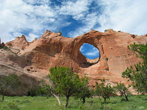
Der "Window Rock"Lage im County und in Arizona 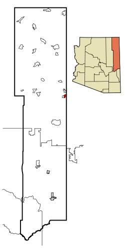
Basisdaten Staat: Vereinigte Staaten Bundesstaat: Arizona County: Koordinaten: 35° 40′ N, 109° 4′ W35.6725-109.061944444442082Koordinaten: 35° 40′ N, 109° 4′ W Zeitzone: Mountain Standard Time (UTC−7) Einwohner: 3059 (Stand: 2000) Bevölkerungsdichte: 228,3 Einwohner je km² Fläche: 34,7 km² (ca. 13 mi²)
davon 13,4 km² (ca. 5 mi²) LandHöhe: 2082 m Postleitzahl: 86515 Vorwahl: +1 928 FIPS: 04-83720 GNIS-ID: 0013908 Window Rock (Navajo: Tségháhoodzání) ist ein census-designated place im Apache County im US-Bundesstaat Arizona. Window Rock hat 3.059 Einwohner auf einer Fläche von 13 km². Die Bevölkerungsdichte liegt bei 227,6/km². Window Rock ist zudem die Hauptstadt der Navajo-Nation, dem selbstverwalteten Territorium der Navajo-Indianer, die sich selbst Diné nennen.. Er liegt in einer Höhe von 2103 m.ü.M auf dem Defiance Plateau. Window Rock wird von der Arizona State Route 264 erschlossen.
Weblinks
 Commons: Window Rock, Arizona – Sammlung von Bildern, Videos und AudiodateienKategorien:
- Ort in Arizona
- Apache County


Wikimedia Foundation.