- Swartland
-
Swartland
Swartland Local Municipality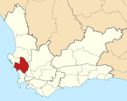
Basisdaten Staat Südafrika Provinz Westkap Distrikt Westküste Sitz Malmesbury Fläche 3.692 km² Einwohner 77.520 (24. Oktober 2007) Dichte 21 Einwohner pro km² Schlüssel WC015 ISO 3166-2 ZA-WC Webauftritt www.swartland.org.za (englisch) Politik Bürgermeister Tijmen van Essen -33.4518.733333333333Koordinaten: 33° 27′ S, 18° 44′ OSwartland ist eine Gemeinde im Distrikt Westküste, Provinz Westkap in Südafrika. Im Jahr 2001 betrug die Bevölkerung 72.105 auf einer Gesamtfläche von 3.692 km². Sitz der Gemeindeverwaltung ist Malmesbury.[1]
Swartland ist Afrikaans für „schwarzes Land“. Jan van Riebeeck, Gouverneur der Kapprovinz, entsandte 1652 einen seiner Beamten (Cieter Cruyhos) zu Forschungszwecken ins Landesinnere. Er kam zurück und erklärte ihm, dass die Landschaft schwarz sei, dieses bezog sich auf die Färbung des Nashornbusches (Renosterbos Elytropappus rhinocerotis[2]) im Sommer. Dieser ist nach ausgiebigen Regenfällen dann so dunkelgrün, dass die Farbe Schwarz ähnelt.[3] Auf dem Boothmanskloof gibt es einen Gedenkstein zu seiner Reise 1662. Das Tal nannte er dann zu Ehren des Gouverneurs Riebeek-Valley. Für 1683 sind Auseinandersetzungen mit den Khoi in Zonquasdrift nachweisbar.
Städte
- Abbotsdale
- Bergsig
- Darling
- Doornkloof
- Koringberg
- Malmesbury
- Moorreesburg
- Myrtledene
- Nuwedorp
- Riebeek Kasteel
- Riebeek West
- Rosenhof
- Steynsburg
- Yzerfontein
Weblinks
Quellen
- ↑ Municipal Demarcation Board
- ↑ Renosterveld
- ↑ http://www.cyberserv.co.za/users/~jako/lang/munnames.htm
Gemeinden des Distriktes WestküsteBergrivier | Cederberg | Matzikama | Saldana Bay | Swartland
Wikimedia Foundation.
Schlagen Sie auch in anderen Wörterbüchern nach:
Swartland — The Swartland begins some 50 kilometres north of Cape Town and consists of the regions between the towns of Malmesbury in the south, Darling in the west, Piketberg in the north and the Riebeeck West and Riebeek Kasteel in the east. Jan van… … Wikipedia
Swartland Local Municipality — Zamuni code= WC015 location= West Coast District Municipality, Western Cape Province area= neighbours= mayor=Anton Bredell (DA) population= 72,115 population density= habitations= habitation density= races= languages= website=… … Wikipedia
Early life of Jan Smuts — Jan Christian Smuts (aka Jan Christiaan Smuts), OM, CH, ED, KC, FRS (24 May 1870 ndash; 11 September 1950) was a prominent South African and Commonwealth statesman, military leader, and philosopher. He served as a Boer General during the Boer War … Wikipedia
Yzerfontein — Yzerfontein … Deutsch Wikipedia
Moorreesburg — Town … Wikipedia
The Sadie Family — is a South African producer of wine located in the Swartland region. Following the emergence of flagship wines Columella and Palladius, winemaker Eben Sadie has been described as an enfant terrible, South Africa s first certified celebrity… … Wikipedia
Western Cape — Wes Kaap (Afrikaans) Ntshona Koloni (Xhosa) Province of South Africa The P … Wikipedia
Drakenstein Local Municipality — Drakenstein Plaaslike Munisipaliteit UMasipala weNgingqi yaseDrakenstein Local municipality … Wikipedia
Matzikama Local Municipality — Matzikama Plaaslike Munisipaliteit UMasipala weNgingqi yaseMatzikama Local municipality … Wikipedia
City of Cape Town — This article is about the municipality. For the city itself, see Cape Town. City of Cape Town Stad Kaapstad IsiXeko saseKapa Metropolitan municipality … Wikipedia
Swartland

18+
© Academic, 2000-2024
- Kontaktieren Sie uns: Unterstützung, Werbung
Wörterbücher Export, schritte mit PHP, Joomla, Drupal, WordPress, MODx.