- Senqu
-
Senqu
Senqu Local Municipality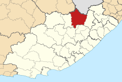
Symbole Wappen
Wahlspruch
„Abantu Abanye, Umasipalati Omnye, Uhambo Olunye“Basisdaten Staat Südafrika Provinz Ostkap Distrikt Joe Gqabi Sitz Lady Grey Fläche 7.330 km² Einwohner 118.174 (24. Oktober 2007) Dichte 16,1 Einwohner pro km² Schlüssel EC142 ISO 3166-2 ZA-EC Webauftritt www.senqumunicipality. co.za (englisch) Politik Bürgermeister Nozibele Mtyali -30.727.233333333333Koordinaten: 30° 42′ S, 27° 14′ OSenqu ist eine Gemeinde im Distrikt Joe Gqabi, Provinz Ostkap, Südafrika. Auf einer Fläche von 7.330 km² leben 135.723 Einwohner (Stand 2001). Sitz der Gemeindeverwaltung ist Lady Grey. Ein Teil der Gemeinde lag bis 1994 auf dem Territorium der Transkei.
Senqu ist der Sesothoname des Flusses Oranje, an dem die Gemeinde liegt.
Städte/Orte
- Barkly East
- Lady Grey
- Rhodes
- Sterkspruit
Weblinks
Schlagen Sie auch in anderen Wörterbüchern nach:
Senqu River — The Senqu River is a river located in the rural highlands in the district of Mokhotlong in the country of Lesotho in Southern Africa. Its tributaries include the Senqunyane River.Wild lifeThe Senqu river has a small native fish population, some… … Wikipedia
Orange River — For other uses, see Orange River (disambiguation). Orange Gariep, Oranje, Senqu River … Wikipedia
Lesotho Highlands Water Project — The Lesotho Highlands Water Project is an ongoing water supply project with a hydropower component, developed in partnership between the governments of Lesotho and South Africa. It comprises a system of several large dams and tunnels throughout… … Wikipedia
Oranje (Fluss) — Oranje DatenVorlage:Infobox Fluss/GKZ fehlt … Deutsch Wikipedia
Geography of Lesotho — Coordinates: 29°30′S 28°30′E / 29.5°S 28.5°E / 29.5; 28.5 … Wikipedia
Lesotho Highland Water Project — Staumauer des Katse Stausees Das Lesotho Highlands Water Project (deutsch: Lesotho Hochland Wasser Projekt, Süd Sotho: metsi a lihlaba) ist ein Talsperrenprojekt im Inneren des Königreichs Lesotho, das die südafrikanische Großregion Gauteng um… … Deutsch Wikipedia
Lesotho Highlands Water Project — Staumauer des Katse Stausees Das Lesotho Highlands Water Project (deutsch: Lesotho Hochland Wasser Projekt, Sesotho: metsi a lihlaba) ist ein Talsperrenprojekt im Inneren des Königreichs Lesotho, das die südafrikanische Großregion Gauteng um die… … Deutsch Wikipedia
Lesotho Hochland Wasser Projekt — Staumauer des Katse Stausees Das Lesotho Highlands Water Project (deutsch: Lesotho Hochland Wasser Projekt, Süd Sotho: metsi a lihlaba) ist ein Talsperrenprojekt im Inneren des Königreichs Lesotho, das die südafrikanische Großregion Gauteng um… … Deutsch Wikipedia
Quthing (Distrikt) — Tal des Senqu bei Mount Moorosi Karte … Deutsch Wikipedia
Eastern Cape — Oos Kaap (Afrikaans) Mpuma Kapa (Xhosa) Province of South Africa The Provi … Wikipedia
Senqu


18+
© Academic, 2000-2024
- Kontaktieren Sie uns: Unterstützung, Werbung
Wörterbücher Export, schritte mit PHP, Joomla, Drupal, WordPress, MODx.