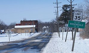
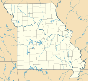
Rosendale, Missouri — Infobox Settlement official name = Rosendale, Missouri settlement type = City nickname = motto = imagesize = image caption = image imagesize = image caption = image mapsize = 250x200px map caption = Location of Rosendale, Missouri mapsize1 = map… … Wikipedia
Rosendale — may refer toIn England: *Rosendale Road in South London marks the western edge of West DulwichIn the United States: *Rosendale, Missouri *Rosendale, New York *Rosendale, Wisconsin *Rosendale (town), Wisconsin *Rosendale Township, Minnesota… … Wikipedia
Rosendale — ist der Name mehrerer Townships in den Vereinigten Staaten: Rosendale (Missouri) Rosendale (New York) Rosendale (Wisconsin) Rosendale Township (Watonwan County, Minnesota) Diese Seite ist eine Begriffsklärung … Deutsch Wikipedia
Missouri locations by per capita income — Missouri is the thirtieth richest state in the United States of America[citation needed], with a per capita income of $19,936 (2000).[1] Missouri places ranked by per capita income Baker, Missouri – $182,000 Huntleigh, Missouri – $104,420 Country … Wikipedia
Rosendale — Rosendale, WI U.S. village in Wisconsin Population (2000): 923 Housing Units (2000): 339 Land area (2000): 1.119741 sq. miles (2.900117 sq. km) Water area (2000): 0.000000 sq. miles (0.000000 sq. km) Total area (2000): 1.119741 sq. miles… … StarDict's U.S. Gazetteer Places
Rosendale, MO — U.S. city in Missouri Population (2000): 180 Housing Units (2000): 76 Land area (2000): 0.311201 sq. miles (0.806008 sq. km) Water area (2000): 0.000000 sq. miles (0.000000 sq. km) Total area (2000): 0.311201 sq. miles (0.806008 sq. km) FIPS code … StarDict's U.S. Gazetteer Places
Andrew County, Missouri — Infobox U.S. County county = Andrew County state = Missouri founded year = 1841 founded date = seat wl = Savannah largest city wl = area total sq mi = 436 area total km2 = 1131 area land sq mi = 435 area land km2 = 1127 area water sq mi = 1 area… … Wikipedia
List of cities in Missouri — In Missouri, cities are classified into three types: Class 3, Class 4, and those under constitutional charters. A few older cities are incorporated under legislative charters (Carrollton, Chillicothe, LaGrange, Liberty, Miami, Missouri City, and… … Wikipedia
Nodaway, Missouri — Township … Wikipedia
Liste der Städte in Missouri — Die folgende Liste zeigt alle Kommunen und Siedlungen in Missouri. Sie enthält sowohl Citys als auch Census designated places (CDP). Die obere Tabelle enthält die Siedlungen, die bei der Volkszählung im Jahr 2010[1] mehr als 10.000 Einwohner … Deutsch Wikipedia