- Nxuba
-
Nxuba
Nxuba Local Municipality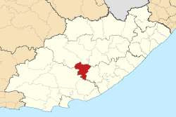
Symbole Wappen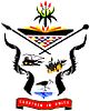
Wahlspruch
„Together in Unity“
Gemeinsam in EintrachtBasisdaten Staat Südafrika Provinz Ostkap Distrikt Amathole Sitz Adelaide Fläche 2.732 km² Einwohner 21.473 (24. Oktober 2007) Dichte 7,9 Einwohner pro km² Schlüssel EC128 ISO 3166-2 ZA-EC Webauftritt www.nxuba.co.za (englisch) Politik Bürgermeister Louisa Leonora Bruintjies -32.726.3Koordinaten: 32° 42′ S, 26° 18′ ODie Gemeinde (Local Municipality ) Nxuba ist Teil des Distriktes Amathole, Provinz Ostkap in Südafrika. Auf einer Fläche von 2.732 km² leben 24.814 Einwohner (Stand 2001). Sitz der Gemeindeverwaltung ist Adelaide.
Gemeinsam mit der Local Municipality Nkonkobe bildet dieser Verwaltungsdistrikt den Fort Beaufort Education District (deutsch etwa: Fort Beaufort Schulbezirk).[1]
Städte/Orte
- Adelaide
- Bedford
- Lingelethu
- Sizakhele
Weblinks
- Offizieller Internetauftritt (englisch)
- Municipal Demarcation Board
- South African Local Government Assotiation
Einzelnachweise
Schlagen Sie auch in anderen Wörterbüchern nach:
Nxuba Local Municipality — Local municipality Location in the … Wikipedia
Eastern Cape — Oos Kaap (Afrikaans) Mpuma Kapa (Xhosa) Province of South Africa The Provi … Wikipedia
Xhosa clan names — (isiduko (sing.), iziduko (pl.) in Xhosa) are family names which are considered more important than surnames. Much like the clan system of Scotland, each Xhosa person can trace their family history back to a specific male ancestor or stock.… … Wikipedia
Amahlati — Local Municipality Amahlati (rot) in Ostkap Staat: Südafrika … Deutsch Wikipedia
Amatole — District Municipality Amatole (blau) in Ostkap (dunkelgrau) Staat: Südafrika … Deutsch Wikipedia
Bedford (Südafrika) — Bedford … Deutsch Wikipedia
Buffalo City (Gemeinde) — Die Gemeinde (Local Municipality ) Buffalo City ist Teil des Distriktes Amatole, Provinz Ostkap in Südafrika. Auf einer Fläche von 2.528 km² leben 702.271 Einwohner (Stand 2001). Sitz der Gemeindeverwaltung ist East London. Städte/Orte Bisho East … Deutsch Wikipedia
Eastern Cape — Oos Kaap Ostkap Wappen Basisdaten Hauptstadt: Bisho Fläche: Rang: in % Südafrikas … Deutsch Wikipedia
Liste der Gemeinden Südafrikas — Dies ist eine Liste der südafrikanischen Gemeinden. Inhaltsverzeichnis 1 Metropolgemeinden 2 Freistaat 2.1 Xhariep – Xhariep District Municipality (DC16) 2.2 … Deutsch Wikipedia
Nkonkobe — Local Municipality Basisdaten … Deutsch Wikipedia
Nxuba


18+
© Academic, 2000-2024
- Kontaktieren Sie uns: Unterstützung, Werbung
Wörterbücher Export, schritte mit PHP, Joomla, Drupal, WordPress, MODx.