Muswellbrook Shire

Muswellbrook Shire
Shire of Muswellbrook
Australia-Map-NSW-LGA-Muswellbrook.png
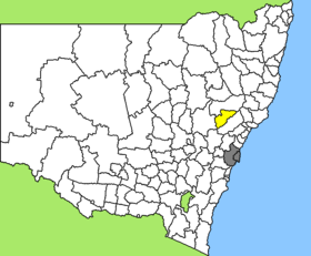
Lage des Muswellbrook Shire in New South Wales
Gliederung
Staat: Australien Australien
Bundesstaat: Flag of New South Wales.svg New South Wales
Verwaltungssitz: Muswellbrook
Daten und Zahlen
Fläche: 3.406 km²
Einwohner: 15.236 (2006) [1]
Bevölkerungsdichte: 4,5 Einwohner je km²
-32.4150.68333333333

Muswellbrook Shire ist ein lokales Verwaltungsgebiet (LGA) im australischen Bundesstaat New South Wales. Das Gebiet ist 3.406 km² groß und hat etwa 15.000 Einwohner.

Muswellbrook liegt im Osten des Staates in der Region um den Hunter River etwa 270 km nördlich der Metropole Sydney. Das Gebiet umfasst 56 Ortsteile und Ortschaften, darunter Baerami, Baerami Creek, Castle Rock, Denman, Glen Gallic, Kayuga, Kerrabee, McCullys Gap, Muscle Creek, Muswellbrook, Sandy Hollow und Widden, Wybong. Der Sitz des Shire Councils befindet sich in der Stadt Muswellbrook im Nordosten der LGA, wo etwa 10.000 Einwohner leben.

Verwaltung

Der Muswellbrook Shire Council hat zwölf Mitglieder, die von den Bewohnern der LGA gewählt werden. Muswellbrook ist nicht in Bezirke untergliedert. Aus dem Kreis der Councillor rekrutiert sich auch der Mayor (Bürgermeister) des Councils.

Weblinks

Einzelnachweise

  1. Australian Bureau of Statistics (25. Oktober 2007): Muswellbrook (A) (Local Government Area) (Englisch). 2006 Census QuickStats. Abgerufen am 6. April 2010.

Wikimedia Foundation.

Игры ⚽ Нужна курсовая?

Schlagen Sie auch in anderen Wörterbüchern nach:

  • Muswellbrook Shire — New South Wales Location in New South Wales Population …   Wikipedia

  • Muswellbrook Shire Council — Infobox Australian Place | type = lga name = Muswellbrook Shire caption = Location in New South Wales state = New South Wales region = Hunter Valley area = 3406 est = seat = Muswellbrook (Maitland Street)cite web title=Muswellbrook Shire Council… …   Wikipedia

  • Muswellbrook, New South Wales — Muswellbrook New South Wales Muswellbrook South …   Wikipedia

  • Muswellbrook — South Staat …   Deutsch Wikipedia

  • Muswellbrook — /ˈmʌsəlbrʊk/ (say musuhlbrook) noun 1. a town and shire in the upper Hunter Valley, NSW; coalmining and grape growing. –phrase 2. things are crook in Muswellbrook, NSW Colloquial present circumstances are bad. Compare Chiefly NSW Colloquial… …  

  • Wakool Shire — Shire of Wakool New South Wales Location in New South Wales Population: 4,427(2009) …   Wikipedia

  • Dungog Shire — New South Wales Location in New South Wales Population …   Wikipedia

  • Singleton Shire Council — Infobox Australian Place | type = lga name = Singleton Shire caption = Location in NSW state = New South Wales region = Hunter area = 4896 est = seat = Singleton (Queen Street)cite web title=Singleton Shire Council publisher = Department of Local …   Wikipedia

  • Conargo Shire — New South Wales Location in New South Wales Population: 1,700(2009) …   Wikipedia

  • Murray Shire — This article is about the Murray Shire in New South Wales. For the Western Australia shire, see Shire of Murray. Murray Shire New South Wales …   Wikipedia

Share the article and excerpts

Direct link
Do a right-click on the link above
and select “Copy Link”