Murrumbidgee Shire

Murrumbidgee Shire
Shire of Murrumbidgee
Australia-Map-NSW-LGA-Murrumbidgee.png
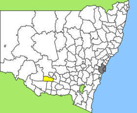
Lage des Murrumbidgee Shire in New South Wales
Gliederung
Staat: Australien Australien
Bundesstaat: Flag of New South Wales.svg New South Wales
Verwaltungssitz: Darlington Point
Daten und Zahlen
Fläche: 3.505 km²
Einwohner: 2.503 (2006) [1]
Bevölkerungsdichte: 0,7 Einwohner je km²
Wards: 3
-34.8145.88333333333

Murrumbidgee Shire ist ein lokales Verwaltungsgebiet (LGA) im australischen Bundesstaat New South Wales. Das Gebiet ist 3.505 km² groß und hat etwa 2.500 Einwohner.

Murrumbidgee liegt zentral im Süden des Staates südlich des Murrumbidgee River etwa 400 km westlich der australischen Hauptstadt Canberra und 420 km nördlich von Melbourne. Das Gebiet umfasst 12 Ortsteile und Ortschaften: Clifford Downs, Coleambally, Cooinbil, Dirrung, Ercildoune, Gum Creek, Toganmain, Tubbo, Uri East, und Waddi sowie Teile von Darlington Point und Four Corners. Der Sitz des Shire Councils befindet sich in Darlington Point im Nordosten der LGA, wo etwa 1.000 Einwohner leben.

Verwaltung

Der Murrumbidgee Shire Council hat acht Mitglieder, die von den Bewohnern der zwei Wards gewählt werden (je vier aus East und West Ward). Diese beiden Bezirke sind unabhängig von den Ortschaften festgelegt. Aus dem Kreis der Councillor rekrutiert sich auch der Mayor (Bürgermeister) des Councils.

Weblinks

Einzelnachweise

  1. Australian Bureau of Statistics (25. Oktober 2007): Murrumbidgee (A) (Local Government Area) (Englisch). 2006 Census QuickStats. Abgerufen am 6. April 2010.

Wikimedia Foundation.

Игры ⚽ Нужен реферат?

Schlagen Sie auch in anderen Wörterbüchern nach:

  • Murrumbidgee Shire — New South Wales Murrumbidgee Shire office and chambers Populat …   Wikipedia

  • Murrumbidgee Shire — Admin ASC 2 Code Orig. name Murrumbidgee Shire Country and Admin Code AU.02.15550 AU …   World countries Adminstrative division ASC I-II

  • Murrumbidgee Shire Council — Infobox Australian Place | type = lga name = Murrumbidgee Shire caption = Murrumbidgee Shire office and chambers state=New South Wales region=Riverina area = 3504.58 area footnotes = [cite web|title = Murrumbidgee Regional Profile | url =… …   Wikipedia

  • Murrumbidgee — is the name of a river in New South Wales, Australia. It may refer to: Murrumbidgee River Murrumbidgee River Rail Bridge (Wagga Wagga) Murrumbidgee Irrigation Area Murrumbidgee Red Gums Important Bird Area Murrumbidgee Co operative Milling,… …   Wikipedia

  • Electoral district of Murrumbidgee — Murrumbidgee is an electoral district of the Legislative Assembly in the Australian state of New South Wales, named after the Murrumbidgee River. It is represented by Adrian Piccoli of the National Party of Australia.According to the report for… …   Wikipedia

  • Wakool Shire — Shire of Wakool New South Wales Location in New South Wales Population: 4,427(2009) …   Wikipedia

  • Balranald Shire — Shire of Balranald Lage des Balranald Shire in New South Wales Gliederung …   Deutsch Wikipedia

  • Carrathool Shire — Shire of Carrathool Lage des Carrathool Shire in New South Wales Gliederung …   Deutsch Wikipedia

  • Coolamon Shire — Shire of Coolamon Lage des Coolamon Shire in New South Wales Gliederung …   Deutsch Wikipedia

  • Cootamundra Shire — Shire of Cootamundra Lage des Cootamundra Shire in New South Wales Gliederung …   Deutsch Wikipedia

Share the article and excerpts

Direct link
Do a right-click on the link above
and select “Copy Link”