- Mount Rogers
-
Mount Rogers 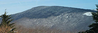
Mount Rogers im Winter
Höhe 1.746 m Lage Virginia, Vereinigte Staaten Gebirge Blue Ridge Mountains Geographische Lage 36° 39′ 35″ N, 81° 32′ 41″ W36.659722222222-81.5447222222221746Koordinaten: 36° 39′ 35″ N, 81° 32′ 41″ W 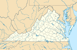

Erstbesteigung Unbekannt Besonderheiten Höchster Berg in Virginia Mount Rogers ist der höchste Berg im US-Bundesstaat Virginia. Er gehört zur Gebirgskette der Blue Ridge Mountains. Der Berg hat eine Höhe von 1.746 m über dem mittleren Meeresspiegel, der Gipfel befindet sich im Grayson County etwa 10 km von Trout Dale entfernt. Er ist Teil der Mount Rogers National Recreation Area. Er lässt sich sehr leicht über ausgewiesene Wanderwege erreichen.
Siehe auch
Weblinks
- Mount Rogers bei Peakbagger.com (englisch)
Kategorien:- Eintausender
- Berg in den Appalachen
- Berg in Nordamerika
- National Recreation Area (Vereinigte Staaten)
- Berg in den Vereinigten Staaten


Wikimedia Foundation.