- Mount Gareloi
-
Mount Gareloi 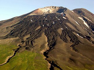
Südflanke des Mount Gareloi
Höhe 1.573 m Lage Insel Gareloi, Aleuten, Alaska Gebirge Aleutenkette Geographische Lage 51° 47′ 25″ N, 178° 47′ 38″ W51.790277777778-178.793888888891573Koordinaten: 51° 47′ 25″ N, 178° 47′ 38″ W 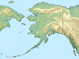

Typ Schichtvulkan Letzte Eruption 17. August 1989 Der Mount Gareloi ist ein Schichtvulkan, der den wesentlichen Teil der Insel Gareloi in den Aleuten (Alaska) bildet.
Inhaltsverzeichnis
Aufbau
Der Vulkan hat an seinem Fuß einen Durchmesser von acht bis zehn Kilometern, erreicht eine maximale Höhe von 1573 Metern und verfügt über zwei Krater. Der von Fumarolen überzogene südlichere Krater ist größer und misst etwa 300 Meter im Durchmesser, bedingt durch die teilweise abgerutschte Südwand. In der Südwand befindet sich ein Riss, der beim Ausbruch im Jahr 1929 entstanden ist und sich bis zur Küste zieht. Der nördliche Krater ist von Lavaströmen bedeckt. An seiner Nordwestflanke hat augenscheinlich ein Domeinsturz stattgefunden. Das Alaska Volcano Observatory hat den Vulkan und seine Umgebung 2003 kartografiert.[1] Außerdem wurden Seismographen installiert.[2]
Eruptionsgeschichte
Seit der Entdeckung der Insel 1741 wurden etwa zwölf Ausbrüche registriert, die von Lavaströmen und pyroklastischen Strömen begleitet waren. In der Regel erfolgte zunächst ein Ausbruch des Hauptschlotes, gefolgt von einem explosiven Gas- und Ascheausbruch, teilweise von einer phreatischen Explosion.[3] Die Ausbrüche wurden mit einem Vulkanexplosivitätsindex von 1 bis 3 klassifiziert.[4] Solche Ausbrüche fanden 1790, 1791, 1792, 1873, 1922, im April 1929, 1950, am 17. Januar 1952, am 7. August 1980, am 15. Januar 1982, am 4. September 1987 und am 17. August 1989 statt. Weitere Eruptionen in den Jahren 1760, 1828, 1927 und 1996 sind nicht gesichert.[3]
Der Ausbruch 1929 war der bisher schwerste in der jungen Erforschungsgeschichte des Vulkans. Vier Lavaströme entstanden neu. In der Südflanke des Berges entstand ein großer Riss mit 13 kleinen Kratern. Den Ablagerungen nach ging der Ausbruch mit pyroklastischen Strömen und Lahar-Strömen einher.
Literatur
- Michelle L. Coombs, Robert G. McGimsey und Brandon L. Browne (2008) (PDF). Preliminary Volcano-Hazard Assessment for Gareloi Volcano, Gareloi Island, Alaska. (Scientific Investigations Report 2008–5159.) United States Geological Survey.
- Christina A. Neal, Robert G. McGimsey, Jim Dixon und Dmitry Melnikov (2005). 2004 Volcanic Activity in Alaska and Kamchatka: Summary of Events and Response of the Alaska Volcano Observatory. (Open-File Report 2005-1308.) United States Geological Survey.
- Charles Arthur Wood und Jürgen Kienle (1992). Volcanoes of North America. Cambridge University Press.
Weblinks
- Mount Gareloi im Global Volcanism Program der Smithsonian Institution (englisch)
Einzelnachweise
- ↑ Informationen des AVO
- ↑ Neal, McGimsey, Dixon und Melnikov, Seite 1.
- ↑ a b Informationen des Smithsonian Instituts
- ↑ Informationen von Volcano World.
Kategorien:- Eintausender
- Schichtvulkan
- Berg in der Aleutenkette
- Berg in Alaska
- Berg in Nordamerika


Wikimedia Foundation.