- Mokotów
-

Mokotów
Bezirk von Warschau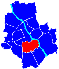
Koordinaten 52° 12′ 0″ N, 21° 1′ 0″ O52.221.016666666667Koordinaten: 52° 12′ 0″ N, 21° 1′ 0″ O Fläche 35,4 km² Einwohner 226.064 (2008) Bevölkerungsdichte 6382 Einwohner/km² Website http://www.mokotow.waw.pl Politik Bürgermeister Robert Soszyński Mokotów ist ein dicht bevölkerter Stadtbezirk der polnischen Hauptstadt Warschau und Sitz vieler Unternehmen und ausländischer Botschaften. Nur in kleineren Bereichen wurden im Stadtbezirk Industriebetriebe angesiedelt (Służewiec Przemysłowy), auf größeren Flächen sind Parks und andere Grünanlagen angelegt worden.
Obwohl das Gebiet bereits mindestens seit dem frühen Mittelalter besiedelt war, hat es bis 1916 gedauert, bis Mokotów ein Stadtteil von Warschau wurde. Der Name des Gebietes leitet sich vermutlich von dem früheren Dorfnamen Mon Coteau (französisch für Mein Hügel) ab, was sich zu dem seit dem 14. Jahrhundert bekannten Namen Mokotów weiterentwickelt hat. Der größte Teil des Stadtteils wurde erst in den 1920er und 1930er Jahren städtisch bebaut. Mokotów überstand den Zweiten Weltkrieg und die Ereignisse des Warschauer Aufstands auf Grund der Tatsache, dass es den deutschen Besatzungstruppen als exklusives Wohngebiet vorbehalten war, relativ unbeschadet und gilt im heutigen Warschau als gut erhaltener Stadtteil.
Erwähnenswerte Anlagen und Gebäude im Stadtteil:
- Hafen Czerniaków, ältester Warschauer Flusshafen
- Fort Tsche der Festung Warschau
- Galeria Mokotów, ein modernes Einkaufszentrum
- Handelshochschule Warschau
- Kraftwerk Siekierki
- Królikarnia-Palast
- Park Morskie Oko
- Polskie Radio i Telewizja, der polnische Rundfunk
- Pole Mokotowskie, ein großer Park
- Rakowiecka Gefängnis
Literatur
- Nikolai Roskamm, Katarzyna Pluta (Hrsg.): Mokotow - meeting point of culture and nature – Urban Design Workshop 2007. (= ISR Graue Reihe Heft 8). Institut für Stadt- und Regionalplanung, TU Berlin 2007, ISBN 978-3-7983-2071-0 (Volltext)
Weblinks
 Commons: Mokotów – Sammlung von Bildern, Videos und Audiodateien
Fußnoten
Schlagen Sie auch in anderen Wörterbüchern nach:
Mokotów — Warsaw District Coat of arms … Wikipedia
Mokotow — Mokotów Basisdaten … Deutsch Wikipedia
Mokotow — Mokotów Mokotów Maire d arrondissement E … Wikipédia en Français
Mokotów — Distrito de Polonia Entidad … Wikipedia Español
Mokotów — 52° 12′ 00″ N 21° 01′ 01″ E / 52.2, 21.01694444 … Wikipédia en Français
Mokotów Prison — (Polish: Więzienie mokotowskie, also known as Rakowiecka Prison) is a prison in Warsaw s borough of Mokotów, Poland, located at Rakowiecka 37 street. It was built by the Russians in the final years of the foreign Partitions of Poland. During the… … Wikipedia
Mokotów Fields — Infobox park park=Pole Mokotowskie image size=250px caption= Pole Mokotowskie in autumn type=Municipal location=Warsaw coordinates= size=65 ha [pl icon cite web |author = |url = http://um.warszawa.pl/v syrenka/zielona/?dz id=1 mi id=52 |title =… … Wikipedia
Mokotów Field — Pole Mokotowskie Pole Mokotowskie in autumn Type Municipal Location Warsaw … Wikipedia
Mokotow — Original name in latin Mokotw Name in other language State code PL Continent/City Europe/Warsaw longitude 52.1934 latitude 21.03487 altitude 83 Population 212670 Date 2012 11 09 … Cities with a population over 1000 database
Flughafen Mokotów — Flugplatz Gedenkstein im heutigen Park „Pole Mokotowskie“ Auf … Deutsch Wikipedia
Mokotów

18+
© Academic, 2000-2024
- Kontaktieren Sie uns: Unterstützung, Werbung
Wörterbücher Export, schritte mit PHP, Joomla, Drupal, WordPress, MODx.